


![]()
Вы здесь
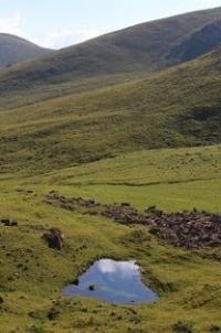
Sokuluk (Belogorka) gorge.
Wildlife Tours Kyrgyzstan.
"From a granite cliff, from a haughty height
You look down, morose giant
On a wretched world, insignificant, petty, perishable,
Sometimes he seems like that from the heights"
Walking tours through gorges of Kyrgyz ridge.
The Sokuluk or Belogorka gorge is located at an altitude of 1068 to 2300 meters above sea level, located on the northern slope of the Kyrgyz Ala-Too ridge, west of the Ala-Archa gorge in the Sokuluk district of the Chui region.
The length of the gorge is 33 kilometers, it starts from the villages of Saz ii Asyylbash and stretches south to the confluence of the Kichitor and Chontor rivers, from where it begins in the upper part, the Sokuluk gorge. From Bishkek, the Sokuluk gorge is located to the southwest, at a distance of 72 km.
On the Sokuluk plain to the west of Bishkek is the village of Tash-Bulak (Stone Stream). It stretches widely along the Sokuluk River, which flows through alpine meadows and forests, where a variety of wildlife is represented.
The village is still known to locals under the Soviet name Belogorka, which was once a thriving collective farm. On the way, to the gorge, in a yurt, you can taste and buy the Kyrgyz national drink - kumis. Sokuluk gorge was visited by climbers in the 50s of the last century.
According to some information, in 1957, the first ascent to the top of the Black Spil was made by a group led by Azim Aitbaev, according to others, in 1958, a group led by V.V. Starodubtsev. At the same time, a number of first ascents to the peaks of the region were made.
There is no exact information about the ascents of that time. It seems that some of the region's peaks have not been conquered. The most interesting for ascents are the upper reaches of the Sokuluk gorge. Access from the city of Bishkek to the village of Sokuluk along the highway.
In the center of Sokuluk village, turn to the south into the mountains near the Orthodox Church. One of the highest waterfalls of the Kyrgyz ridge on the left tributary Sharkyratyr is located in the gorge. Its height is 60 meters. Falling water practically does not reach the ground, spraying and turning into a water cloud.
The way to the waterfall takes only 1 hour. It is often called Pigeon Falls. You will pass through wild bushes and meadows of flowers. Hawthorn, wild currant, barberry, dog rose and even strawberry grow here. Among the mountains there is a trail leading to the Kochkor - Suusamyr highway, which was once used to drive flocks of sheep across the mountains.
It is not currently used as it is generally impassable. There is a route between the Sokuluk and Ala-Archa gorges through the Ozerny pass located at an altitude of 3900 meters above sea level.
Geographic coordinates of Sokuluk gorge: N42 ° 34'31.86 "E74 ° 13'46.08"
Authority:
Issyk-Kul. Naryn "encyclopedia, Frunze, 1991." Kyrgyzstan ", publishing house" Mysl ", Moscow, 1977. www.skitalets.ru http://www.kyrgyzstantravel.info
Photos by
Alexander Petrov.