


![]()
Вы здесь
Lake Kov ata.

Bakharden cave in Turkmenistan.
"Traveling, observing nature, capturing its secrets and delighting in this happiness means living"
F. Gebler.
Bakharden lake in Turkmenistan.
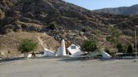
The Bakharden cave with Lake Kov ata is located in the central part on the northeastern slope of the Kopetdag ridge, in the eastern part of the Inzherevinskoe gorge and in the north of the Mergenchukur gorge, 6.8 kilometers to the west and slightly south of the Aktepe village, 16.4 kilometers southeast of the village of Bakherden (Bakharly), 42.1 kilometers northwest of the city of Gekdepe, in the Bakherden etrap of the Akhal velayat.
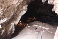
The Baharden Karst Cave is represented by two huge grottoes. The total length of the cave is 250 meters, the depth is 69 meters, the volume is 75,000 cubic meters. The crystal formations are insignificant. Air temperature from 20 - 25 ° C in winter to 27 - 32 ° C in summer.
The cave has an inclined floor of the Main grotto, 57 meters long and 20 meters wide, covered with boulders, covered with guano clusters; karst sinkholes are developed. The second grotto is almost entirely occupied by the underground flowing lake Kov ata, 72 meters long and up to 12 meters deep with thermal 34 - 37 ° C) with hydrogen sulfide water.
Significant mineralization and high temperature - 33 - 37 degrees C indicate that the waters of the Bakharden underground lake rise from great depths. This temperature, as scientists point out, the water could have at about a depth of 600 - 650 meters.
As a result of prolonged leaching of rocks, the Bakharden Cave expanded, especially the upper main hall of the cave, which is distinguished by its considerable height. The second, middle hall, was formed a little later, when tectonic movements gave new fractures in the rocks, along which the lake water moved to lower areas.
A new, second dome was subsequently formed over the lake, which, like the first, was constantly expanding due to the processes of leaching of rocks under the influence of hydrogen sulfide. The latter was accompanied and is now accompanied by the obligatory process of plastering the cavity of the cave.
At present, complex geochemical leaching processes occur every second in the cave, associated with the impact of the rising sulfurous waters of underground sources on the limestones. The age of the cave is estimated at several millennia.
The entrance to the cave has a heart-shaped shape up to 6 meters in diameter, the other three openings are 2 - 3 times smaller than the entrance. The bottom of the cave is 12 meters below the entrance. The cave looks like a long gallery running from the bottom edge of the stairs in a southeast direction and steeply descending downward.
There is a lake at the end of the cave. The walls of the cave, like its vaults, consist of steeply set layers of limestone with blackened dense incrustations (travortics). At a distance of 3 - 5 meters from the shore, the lake is not very deep.
The water level in the lake is 60 meters below the inlet. The shores of the lake are rocky, the walls rise almost vertically, forming an uneven stone vault 10 meters high. In the western part of the lake there is a peninsula (area - 100 square meters), dividing it into two halves.
The water level in the lake varies with the season. In winter it decreases, in summer it rises by 10-15 centimeters. The water in the lake has a weak flow. It is completely transparent and has a faint greenish tint due to artificial lighting.
It is pleasant to the touch and unpleasant to the smell and taste, as it is highly saturated with hydrogen sulfide. According to Associate Professor P.E. Citizen, the amount of hydrogen sulfide in water is 11.0 milligrams per liter.
In addition to hydrogen sulfide, the lake water contains: sodium, calcium, magnesium, barium, aluminum, chlorine, bromine, copper, carbon, etc., a total of 27 elements. The complete chemical composition of water is very complex, and all elements are contained in hundredths and thousandths.
The air in the cave is saturated with moisture and hydrogen sulfide vapors, especially in summer. At this time of the year, drops of water flow down from the vaults of the cave. Of the vegetation in the cave, only some species of lichens were found - representatives of lower plants.
The main and long-standing inhabitants of the cave are bats, about which the naturalists G.I. Rade and A. Walter. Speleofauna is peculiar: bats, rodents, about 50 species of invertebrates. There are 6 species of bats in the cave: common long-winged, pointed-eared, tricolor, bat, Mediterranean, southern large horseshoe bat.
The first two species predominate quantitatively, and the rest, in comparison with them, occupy about 1 - 2%. In addition to bats, wild pigeons and sparrows nest in the front light part of the cave. In almost all parts of the cave, even on the peninsula, there are many cockroaches, darkling beetles, beetles, wood lice.
The cave is electrified and equipped for visiting. The cave has been known since the XVIIIth century.
Geographic coordinates of the Bakharden Cave and Lake Kov ata: N38°18'01,40" E57°31'08,01"
Authority:
Rothko M. A., "Bakhardenskaya cave", Ashgabat, 1958.
Based on materials from the information department of the State Committee of Turkmenistan for Tourism and Sports.
Photos by
Alexander Petrov.