


![]()
Вы здесь
Hunting arans on Mangyshlak.
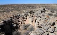
Photo tours in Mangyshlak.
“Everything is not so here, here it breathes heat
Barely broken sprout
And the breeze sways slightly
The Face of the Desert. Here is the East"
Raisa Yasonovna Grigorashvili. "Mangyshlak".
Historical monuments of Mangystau.
Arans are the remnants of driven hunting structures. They are pens of limestone slabs tapering to the cliff of the plateau. Age from 100 to 300 years old. Stone structures in the form of extended rows of stones, deliberately set by a human hand.
These are hunting pens - arans - intended for catching steppe hoofed inhabitants - saigas. Local old-timers say that back in the 30s of the XX century, these buildings were used for their intended purpose. Now they are historical monuments of the economic development of the Ustyurt plateau.
Geographic coordinates of arrows of Ustyurt in vicinity of First panoramic platform in Bozzhyra valley: N43 ° 27'55 E54 ° 02'16
Geographic coordinates of arrows of Ustyurt in vicinity of Fifth panoramic platform in Boszhira valley: N43 ° 24'31 E54 ° 06'22
Geographic coordinates of arrows of Ustyurt in environs of Shomishkol salt land: N45 ° 44'55 E56 ° 02'28
Geographic coordinates of arrows of Ustyurt in environs of Manaysor salt land (Donyztau cliff): N46 ° 13'22 E56 ° 09'39
Geographic coordinates of arrows of Ustyurt onnorthern side of Asmantai-Matai salt land in Aktobe region: N45 ° 43'00 E57 ° 20'03
Authority:
Andrey Astafiev, Aktau town.
Photos by
Alexander Petrov.