


![]()
Вы здесь
History of Kara-Bogaz-Gol gulf.
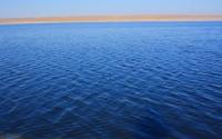
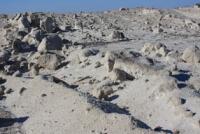
Photo tours to Caspian Sea Turkmenistan.
“The Ajam Sea [Caspian], around which the“ Ajam ”peoples and others roam and live ... bears different names: Babul-Abuabskoye, Khozarskoye, Zhilskoye (Gilanskoye), Dilemskoye, Zhurzhanskoye, Tabaristanskoye. There are several Turkic clans on the coast of this sea. On the one hand, it reaches the cities of Khorezm, which belongs to the territory of Khorasan"
Masoudi, I, 262 - 3.
Photos of Caspian Sea Turkmenistan.
The Kar-Bogaz-Gol bay has a name - Garabogaz Aylagy, Kara-Bugaz, Aji-Darya, Kuli-Darya) (Turk, Kara - "black", bogaz - "throat, bay", goal - "lake, black mouth") there is a bay on the eastern coast of the Caspian Sea, in the north of the Krasnovodsk plateau and the Krasnovodsk bay, in the north-west of Turkmenistan.
The bay is the world's largest deposit of natural marine-type salts. To a certain extent, the bay has long served as a regulator of the level and water and salt balance of the Caspian Sea. It is no coincidence that the Turkmen called it Kuli-darya - "servant of the sea".
It is sometimes called the “leech of the Caspian Sea”. According to ancient legends, there is an abyss in the gulf that absorbs the waters of the Caspian and even ships that ventured into the gulf. The bay is a shallow depression in landform with a flat bottom and an inconsistent coastline.
The first information about the Kara-Bogaz-Gol Bay, discovered by Russian navigators, dates back to the XVIIIth century. In 1705, Alexander Bekovich-Cherkassky made a route survey of the eastern coast of the Caspian Sea and marked a significant part of the bay on the map.
Expedition I.M. Zherebtsova for the first time mapped the sea strait, the coast and the water area of Kara-Bogaz-Gol, measured the depths and velocities of the current, and described the relief of the coast. During the expedition A.A. Lebedintsev (1897), work was carried out to study the conditions for the formation of mirabilite from Karabogaz salts (by this time it had already been established that the bay is a deposit of Glauber's salt - mirabilite).
The Gulf of Kara-Bogaz-Gol is the largest lagoon in the world, separated from the sea by sand bars. Between them there is a strait 7 9 kilometers long (2021 data), 400 - 600 meters wide (2021 data) and 3 - 4 meters deep.
Sea water rushes along the strait at a speed of 50 - 100 cm per second into the bay, where it completely evaporates. Due to the evaporation of the Caspian water and the bay's own “secular” reserves, its bowl is filled with brine - sea water, condensed to more than 300% o.
This brine (brine) is a concentrated solution of salts: sodium, magnesium and potassium chlorides, magnesium sulfate and a small amount of rare earth elements. The physical and geographical conditions of Kara-Bogaz-Gol, its natural regime, depending on the level of the Caspian Sea and the flow into the bay, are experiencing significant interannual changes.
In the first 10 years of the 20th century, the level difference between the sea and the bay was small (about 0.5 meters) and there was a hydraulic connection between them. The level of Kara-Bogaz-Gola was at a level close to - 26.5 meters relative to the level of the World Ocean.
The area of the bay was more than 18,000 square kilometers, the volume of water was 130 cubic kilometers, the prevailing depths were 8 - 10 meters. The inflow of water into the bay was 18 - 25 cubic kilometers per year.
Annually, the bay received about 330 - 380 million tons of salts, but its role in the desalination of the Caspian Sea is insignificant - 0.2 - 0.3% over 100 years. The established water-salt balance between the sea and the bay served as a natural basis for the industrial development of the salt resources of Kara-Bogaz-Gola.
The total salt reserves in the bay are estimated in billions of tons. This is the largest deposits of sodium sulfate in Eurasia and the only place in the world where, in natural conditions of crystallization of mineral salts, they were mined on an industrial scale.
In the first 10 years of the 20th century, the extraction of chemical raw materials was based on natural processes. Crystalline sodium sulfate Na2 [SO4] 10H2O (mirabilite, Glauber's salt) deposited on the bottom of the bay was thrown out on the gentle shores of the bay during winter storms.
In the summer, the water that soaked it evaporated, and the mirabilite was transformed into anhydrous sodium sulfate (thenardite), which was collected at the end of summer. In the early 1930s, the Karabogazsulfat Trust was established for the industrial extraction of salts.
The production was based on a new basin method, where surface brine was pumped into nearby dry basins, and mirabilite precipitated to the bottom as a result of evaporation. The brine without sulphate descended into another pool, and the mirabilite was collected by special machines and shipped to the consumer.
Since the 1930s, due to the long-term decrease in the level of the Caspian Sea, significant changes have occurred in the natural appearance of Kara-Bogaz-Gol. The flow of seawater into the bay decreased to 8-10 cubic kilometers per year, and the water balance was disturbed.
As the sea level decreased, the area of the bay decreased, the depths decreased, the length of the strait increased, and its bottom was washed out. By 1948, the base of erosion had dropped by 2.5 meters. However, in the 1960s, when hard rocks came to the surface, the erosion of the bottom of the strait almost stopped.
The difference in sea and bay levels increased, and at the end of the strait, the world's only sea waterfall with a height of about 3.5 meters was formed. Fish and other living organisms that passed the strait accumulated near its mouth.
A strait with bluish sea water flowing among the yellow sands, a waterfall with the adjacent part of the bay, a peculiar fauna of birds and animals created a unique natural complex on the deserted eastern coast of the Caspian.
A decrease in the volume of Kara-Bogaz-Gol waters, with a prolonged decrease in sea level and the resulting increase in the concentration of salts in the brine, a change in its chemical composition had a negative impact on the conditions for the development of sulfates.
Commercial extraction of salts from surface brines has become unprofitable; it has been replaced by the method of extracting raw materials from buried interstratal brines lying between salt layers under the bottom of the bay and characterized by a constant salt composition.
Since the beginning of the 1950s, the Karabogazsulfat trust began to work only with buried brines. In addition to sodium sulfate, sodium chloride (bischoftite), magnesium sulfate (epsomite), and Glauber's salt were also mined.
In the future, it was planned to comprehensively process brines to obtain a wide range of chemical products (including bromine, boron, magnesium oxide, some rare metals, etc.). During the period of prolonged lowering of the sea level, by the end of the 1970s, the flow of Caspian water into the bay decreased to 5 - 7 cubic kilometers per year, the level of the bay dropped to - 32 meters, the area decreased to 10,000 square kilometers, the volume of water decreased to 20 - 22 cubic kilometers, and the salinity of brine increased to 270 - 290%.
In order to reduce the consumption of the Caspian water and slow down the fall in the level of the Caspian in March 1980, the strait was blocked by a blind dam, and the flow of sea water into the bay stopped. After the separation of the bay, its rapid drying began.
By the end of 1983, the area of the bay was 1000 square kilometers, the volume was 0.2 cubic kilometers, and the depth was 0.1 - 0.3 meters. Salinity reached 330 - 380%. By mid 1984, the bay was almost completely dry.
The surface layer of salts, in the process of precipitation from the brine of the bay, was a hard crystalline rock, consisting mainly of 5 minerals: halite, astrakhanite, epsomite, glauberite and gypsum. Isolation of the bay from the sea caused chemical changes in the composition of salts, buried brines, deterioration of the quality of chemical raw materials and complication of the technology of its processing.
In the context of the beginning of a rapid rise in sea level and in order to preserve and develop the unique salt field, it was decided to restore the flow into the bay. In September 1984, the supply of Caspian water to the gulf through pipelines in the volume of 2 cubic kilometers began, and the gulf gradually returned to its previous shape.
In the summer of 1992, the dam was liquidated and the natural flow of sea water into the bay resumed. With a high position of the Caspian Sea level, the annual volume of this runoff reached 42 - 52 cubic kilometers in 1994 - 1995, significantly exceeding the previously observed values.
By the end of 1995, after filling the basin of the bay, the water discharge through the strait began to be determined only by evaporation from the surface of the bay and decreased to 17 cubic kilometers per year in 1999.
Significant volumes of seawater runoff into the bay in 1992 - 1995 contributed to a decrease in the rate of rise of the Caspian Sea level by more than 30 cm. To date, the bay has completely restored its level and boundaries within the primary shores with an area of about 18,000 square kilometers.
This gives real opportunities to revive the unique natural landscape and ecology of the Kara-Bogaz-Gola region, preserve and use the richest natural resources of the bay.
Geographic coordinates of the Kara-Bogaz-Gol gulf: N41 ° 24'01.61 "E53 ° 32'42.89"
Authority:
N. A. Gvozdetsky, N. I. Mikhailov. "Physical geography of the USSR. Asian part. Third edition, revised and enlarged. Moscow "Mysl" 1978. http://tapemark.narod.ru/geograf/1_5_5.html
Photos by
Alexander Petrov.