


![]()
You are here
Zharkent town.


Tours on towns of Almaty province.
“To hear never-heard sounds,
To see never-seen colors and shapes,
To try to understand the imperceptible
Power pervading the world;
To fly and find pure ethereal substances
That are not of matter
But of that invisible soul pervading reality.
To hear another soul and to whisper to another soul;
To be a lantern in the darkness
Or an umbrella in a stormy day;
To feel much more than know.
To be the eyes of an eagle, slope of a mountain;
To be a wave understanding the influence of the moon;
To be a tree and read the memory of the leaves;
To be an insignificant pedestrian on the streets
Of crazy cities watching, watching, and watching.
To be a smile on the face of a woman
And shine in her memory
As a moment saved without planning”
Dejan Stojanovic.
Guided Bus Tours in Almaty.
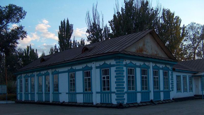
Zharkent (Panfilov city before 1942) received the city status in 1882 in connection with the determination of the south-eastern Russian Imperial border and selection of the district centre there.
The city's location on a brisk trade route promoted its quick economic and social development. Merchants and businessmen constructed a brewery and tobacco factory in Zharkent and opened markets and craft workshops.
The town of Zharkent (known as such from 1881 to 1942. then called Panfilov from 1942 to 1991, before resuming its original name), and its surroundings is heavily populated by Uygyrs.
In the 1880s, 45,000 Uygyrs and 5,000 Djungars moved from western China. into Zhetisu, an emigration caused by the Russo-Chincse St Petersburg Treaty of 1881.
According to the treaty, the territory of Kuldzha (Kulja or Gulja) in the eastern Hi Valley, an area settled by Uygurs at that time, was returned to China, and the resident Islam-oriented population was allowed to choose where to live.
Russia withdrew its troops from the upper IN Valley and stationed them in Zharkent, founded for this purpose, 20 kilometres from the new border. Within a year, Zharkent was granted town status.
Its location in the fertile Hi Plain and its strategic position favoured the development of beer and tobacco production, handicrafts and trade. The prosperous Muslim citizens of Zharkent decided that their town must radiate not only worldly bur also spiritual significance, so they collected money and tasked the merchant Vali Zhuldashev to find a mastcrbuilder for a prestigious mosque.
Thus Chon Pik from China was hired and developed his life's dream in Zharkent between 1887 and 1892. The result was a Muslim place of worship w ith a Chinese Buddhist influence. Zharkent lies on the northern edge of the lie Plain in an area awash with change.
Southeast of the town lies the Karakum Desert, a little sister of it's namesake in Turkmenistan, (they have in common the almost black sand for which they are named). In the south, the He River forms a marshy landscape, while in the north rise the 4,000-metre plus heights of the Toksanbay mountain range.
Adventurers will find beautiful places to roam in the valleys of the rivers Usek, Burchan, Tishkan and Chizin. About 20 kilometres before Zharkent, a metalled road turns off to die north, leading to the settlement of Koktal and into the valley of Borokhuzdir, to the Zharkent Arasan sanatorium (25 km).
You can have a "normal" holiday in the sanatorium, but it's also a good place from which to explore. The town of Khorgoz, 30 kilometres from Zharkent. is the best-known border crossing with China, and a significant part of the Central Asian goods traffic is dealt with here daily; also adventurers with their own vehicles increasingly use this crossing on their way across Central Asia.

Authority:
"Zhetysu is the Land of tourism”. A Tourist Guide-book. Almaty. 2003. 68 p. and the material for this page is taken from the printed edition. 2002. The guidebook across Kazakhstan . Authors Dagmar Schreiber and Jeremy Tredinnick. Publishing house "Odyssey".2010.
Photos
Alexander Petrov.