


![]()
You are here
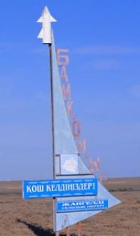
Village of Baikonyr in Ulytau region.
Trip to Baikonir from Zhezkazgan.
“Humanity will not remain on Earth forever... The planet is the cradle of reason, but one cannot live forever in a cradle”
Konstantin Tsiolkovsky.
Trip to Baikonir from Zhezkazgan.
The village of Baikonyr (translated into Kazakh as a rich valley) is located at an altitude 370 of meters above sea level, located in the interfluve of Aschyly and Baikonyr, 50.5 kilometers west of the village of Karsakbay, in the Ulytau district of the region of the same name.
According to one version, the name “Baikonir” is translated from Kazakh as “sandy hills with rich vegetation” or “the area belonging to the bai Konur”. Named in honor of the Kipchak bai Baikonyr, who in 1905 handed over the brown coal mines to the British.
Before this, since 1890, the coal mines belonged to the merchant Surin. The emergence of the village is timed to coincide with the discovery of coal-bearing deposits in outcrops along the banks of the Baikonur rivers by entrepreneurs Surin and Zheleznov in the 90s of the XXth century.
In 1916, the first exploration work was carried out at the field and exploitation began by English concessionaires. The British carried out exploration of coal mines, drilled 54 wells, and in two places layers of brown coal were discovered, which was suitable for use at the copper smelter in Karsakbay.
In 1929, after a break, the exploitation of the field was resumed for the needs of the Karsakbay plant. Mining was carried out in small mines and adits and was discontinued in 1951 due to the development of the main reserves.
During the development of the coal deposit, a miners' settlement began to emerge. 2 kilometers to the east and a little to the south is the Baikonyr railway station on the Zhezkazgan - Saksaulskaya line, which was built between 2012 and 2014; passenger service has been operating on the line since 2016.
To say that the railway revived the village, but most likely this did not happen. The village lives its own life, the main industry of the villagers is livestock farming, and this is what the population of a small village located on the edge of the Aral sands does.
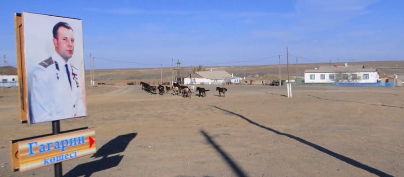
The road that is laid from the village of Karsakbay to Baikonyr - a grader with an endless comb does not add optimism that someday asphalt will be laid here. Back in 2011, there was a street named after Gagarin in the village, at the beginning of which there was a colorful banner with a portrait of the first man who conquered space, now this street has been renamed and the connection with the past is gradually being lost.
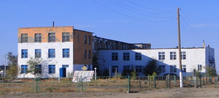
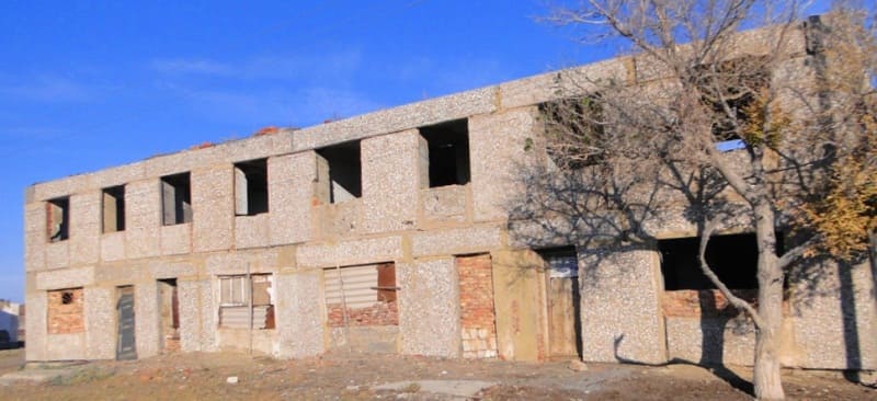
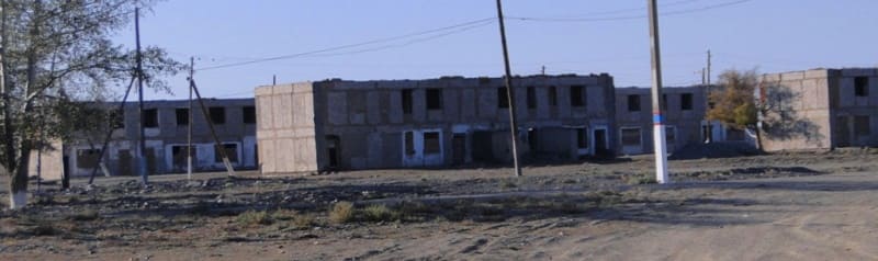
In the village there remains a 2-story, undestroyed building of a military barracks, which was built by military builders during the creation of the so-called false cosmodrome. The remaining brick buildings, which in Soviet times were permanent buildings that housed officers, now have a sad appearance; only ragged walls and some ceilings remain.
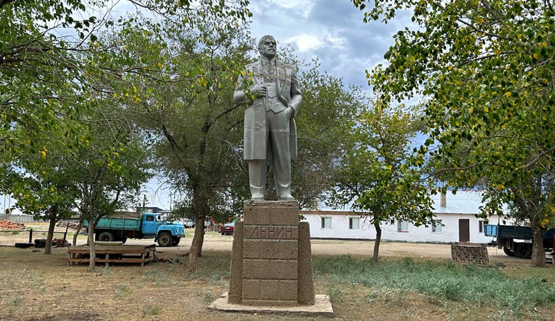
A monument to V.I. has been preserved in the village. Lenin is in fairly good condition, considering that the structure has not been maintained. The monument is located in a tiny park in which old poplars carefully surround the monument from prying eyes.
The village has an interesting history directly related to the famous Baikonur Cosmodrome, which is located in the Kyzylorda region. Let's look through the story and it will tell us a lot of interesting things. This was preceded by well-known events: the United States already had nuclear weapons and in 1945 bombed the Japanese cities of Hiroshima and Nagasaki, which destroyed the cities and claimed tens of thousands of lives.
With this blow, the United States made it clear to the Soviet leadership and the whole world who is the boss in the world and who cannot be disobeyed. On November 14, 1946, in the territories of the Semipalatinsk, Karaganda and Pavlodar regions of the USSR, the Semipalatinsk nuclear test site was established by a resolution of the Council of Ministers of the USSR. Construction of the Semipalatinsk nuclear test site began in August 1947.
At the beginning of 1948, the Council of Ministers of the USSR obliged I.V. Kurchatov, Yu.B. Khariton and P.M. Zernov no later than December 1, 1949 to manufacture and submit the first copies of atomic bombs for state testing.
On August 29, 1949, at 6:20 a.m. local time, on a nice cloudless day, at the command post, nuclear scientists signed an act on the possibility of testing a prototype. On August 29, 1949, the first test of a plutonium bomb was carried out at the Semipalatinsk nuclear test site, a uranium bomb in October 1951, and the first hydrogen warhead in August 1953, the first thermonuclear bomb with a yield of about 1.5 Mt of trinitrotoluene - in October 1955.
So, atomic and nuclear and thermonuclear weapons were tested and thus, the problem naturally arose - how a nuclear charge could be delivered to the territory of a potential enemy who already had such weapons.
The Soviet Union needed to achieve parity in the possession of nuclear weapons and the ability to deliver them for a strike. It is known in history that after the nuclear strikes on Japan, the US leadership openly hinted that the victory of the Soviet Union in the Great Patriotic War no longer mattered and that now the one who has such deadly and destructive weapons is dominant in the world.
For the United States, the results of nuclear weapons tests in the USSR were shocking. It was clear to everyone that the Soviet Union had such super-powerful weapons as the United States. A method of delivering an atomic bomb by plane already existed at that time, but a faster and lightning-fast method of delivering an atomic or nuclear strike in a more modern way was needed.
For this purpose, in 1954, a State Commission was created to select the site for the construction of a test site where the necessary devices could be tested. The head of the Kapustin Yar test site, Lieutenant General of Artillery V.I., was appointed chairman of the commission. Voznyuk.
After reconnaissance of several regions of the country, the commission came up with a proposal to locate a test site in the desert region of Kazakhstan east of the Aral Sea, several hundred kilometers from the village of Baikonir, which is located in the Zhezkazgan region (now Ulytau region).
This place had a number of advantages over others: sparse population not only in the area of the cosmodrome, but also along the route of launched rockets, flat semi-desert terrain, the presence of the largest Central Asian river, the Syr Darya, a railway and a highway passing nearby, more than three hundred sunny days a year and, most importantly, proximity to the equator, which makes it possible to use the additional speed of the Earth’s rotation for launches.
On February 12, 1955, the government decided to build the Baikonur cosmodrome. The famous builder, Major General G.M., was appointed construction manager. Shubnikov. On May 5, 1955, construction began on a residential village for cosmodrome testers, which at different times bore different names: “Tashkent-90”, the “Zarya” village, the “Zvezdograd” village, the city of Leninsk and, since December 1995, the city of Baikonur.
On May 15, 1957, the first launch of the R-7 intercontinental ballistic missile designed by S.P. Korolev was made from the launch site of the test site. The rocket consisted of a central block, four side blocks and a head section, had a length of 32 meters, a maximum diameter of the central block of 2.95 meters, side blocks 19.8 meters long with a maximum diameter of 2.95 meters.
The launch was unsuccessful due to a fire in the tail section. The first and also unsuccessful launch of the Atlas ICBM in the United States took place in June 1957. R-7, launched from the 5th NIIP on August 21, 1957, successfully completed the active part of the trajectory and delivered the warhead to a given area.
Thus, during the missile testing process, the issue of delivering a nuclear charge to enemy territory was resolved. While there was no talk of a cosmodrome at that time, the Soviet leadership set the task of building the necessary services that would facilitate testing the rocket and its further launch into near-Earth space.
At this time, it is important to camouflage and protect the existing test site in the Kyzylorda region, which by this time had been destroyed and turned into a huge testing complex. The location of the Soviet missile test site became known to American intelligence on August 5, 1957 as a result of another flight of a Lockheed U-2 reconnaissance aircraft over the territory of the USSR.
From 1957 until the beginning of the 1990s, in Western sources the test site was designated as Tyuratam (Tyuratam) after the nearest railway station, which was located 30 kilometers from the test site to the south.
In the fall of 1958, large-scale tests were carried out in the Soviet Union in the interests of creating a missile defense system. Three testing sites took part in the tests: Kapustin Yar, Tyura-Tam (NIIP No. 5) and Sary-Shagan.
Near the village of Baikonyr (now Ulytau region), a launch facility was equipped specifically for these tests to launch light missiles tested in Kapustin Yar. All launch equipment and rockets were delivered by rail to Karsakbay station, and Then they are transported by road to their destination.
Barracks, two-story houses for officers were built in the village, and military construction units were located. They were built from wooden structures: a launch pad imitating the real one, various auxiliary structures, garages, warehouses, barracks, a large network of highways was laid imitating the real ones.
This is how a false wooden training ground was created near the village of Baikonir. After the launch of the spaceship "Vostok" on April 12, 1961 with the first cosmonaut of the Earth, Yu. A. Gagarin, the coordinates of the wooden launch pad, which was located near the village of Baikonir, were reported to international organizations as the coordinates of the place from which the "Vostok" launched.
It is unknown when the military left the false test site-cosmodrome near the village of Baikonir.
Geographic coordinates of village of Baikonyr: N47°49'25.69" E66°02'45.80"
Note:
If you are using geographic coordinates for Google Earth or Google Maps navigation systems, you must remove the last two digits from geographic coordinates and " (hundredths of a second) and enter the result in the input line. Example: N51°44'09.67" E72°39'40.81" = N51°44'09 E72°39'40
Authority and photos by
Alexander Petrov.