


![]()
You are here
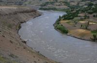
Valley of the Vanch River.
Pamir Mountains Tours in Tajikistan.
"Mountain peaks
They sleep in the darkness of the night;
Quiet valleys
Full of fresh haze;
The road is not dusting
Sheets do not tremble..."
M. Yu. Lermontov.
Trip to Pamir Mountains Tajikistan.
The Vanch River Valley is the most interesting and accessible for travelers along the Darvaz Range. The Vanch River, the right tributary of the Panj, flows through the territory of the Murgab district of the Gorno-Badakhshan Autonomous Region and begins among the spurs of three ridges: Darvaz, Academy of Sciences and Vanch.
The sources of Vanch begin from the Abdukagor River and the stream, conditionally called the Kashal-Ayak River, begins on the glaciers of Abdukagor and the Russian Geographical Society. Both glaciers are connected by Fedchenko glacier basins.
The Vanch Valley from the source stretches in a southwestern direction between the Vanch and Darvaz ranges. The valley continues to the northeast, to the middle course of the Fedchenko Glacier rises the valley of the glacier of the Russian Geographical Society, the largest glacier in the Vanch river basin.
The river flows about 100 kilometers along the south-eastern slopes of the Darvaz Range, Vanch crosses the western Pamir Highway and flows into the Panj. 18 kilometers above the mouth at the confluence of the right tributary of the Roharv, the Vanc district center is located, at an altitude of 1800 meters above sea level. Below the village, a bridge was thrown across the Vanch River on the right bank to the village and Gushkhon Pass through the Vanch Range.
In Vancha, the former village of Roharv, was described in 1905 by the researcher Pamir D.M. Musketov ancient fortress Cala i Vanc. She stood on the way to the Gushkhon pass, along which caravans went to the Yazgulem valley and further to the Pamir.
The houses of the district center are located on the coastal terrace among fields and gardens. The river near the village spills into many branches. Above the village, the valley is partitioned off by river outflow. On its slope are the houses of geologists and a gas station.
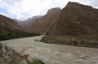
The right tributaries of Vancha lead to passes in the neighboring valleys of Darvaz. The Roharv valley below the Vanch village allows the Vanch (2B) and Roharv (2B) passes to reach the Darharvak glacier and the Darai-Pshiharv valley.
From the Bunai Valley, a simple (2A) Bunai Pass leads to the Darkharvak Valley. Through the Arnavad pass (2A) from the Darai-Arnavad valley, you can get to the Darvaz glacier in the Ob-Mazar basin, and through the Kholodnaya Gora pass (2B) - from the Darai-Techarv valley to the Mazarsky glacier.
Many passes have long been known to local residents. So, pilgrims went to the Mazar Hazrati-Burkh through the Bunai Pass. Residents also know the now impassable pass in the upper Sed Glacier and the descent from the Mazarsky Plateau to the Mazarsky Glacier in the upper Ob-Mazar.
Remains of horse harness were found on the Kholodnaya Gora pass, and cattle were driven to the Bohud valley along the Darai-Shirgovad and Sytarg valleys. A highway has been laid through the village of Vanch to the upper reaches of the valley.
Through the hillock, it rushes past the dam of the hydroelectric station to a wide spill and presses against the conglomerate cliff. Behind the Bunai, Vanch flows in steep, steep banks. The right, Darvazsky slope of the valley is steeper than the left, the terraces and the outflow of tributaries, where the fields are cultivated, are less than on the left.
Therefore, the main road crosses the bridge to the left bank. On the right bank, the road continues at the village of Sed and runs to the mouth of the Darai-Murgutga River. In recent years, it has been extended to Wan-Wan villages and soon it will pass through the mouth of the Garmo-Dary River.
Authority:
Alekseev Alexey Alexandrovich. http://poxod.ru/guidebook/darvaz/index.html
Photos
Alexander Petrov.