


![]()
You are here
Upland Kokshetau.
Tours on Kokshetau Upland.
“We don’t notice the air, we choke without it. So it is with wildlife. Only when we lose it completely, then we realize that we have lost..."
Nikolay Sladkov.
Sights of Kokshetau Upland.
Kokshetau upland (kaz. Kokshetau kyraty) is located in the northwestern part of Saryarka, is located in the northwestern part of the Akmola and eastern parts of the North Kazakhstan regions.
The length of the hill from west to east is 240 kilometers, from northwest to southeast 250 kilometers, the width (from north to south) is 135 kilometers. The average height is 350 - 400 meters above sea level, some massifs reach 600 - 900 meters above sea level.
The highest point of the hill is Mount Kokshe, 947 meters above sea level, the second highest point is the peak of Zhake Batyr, 826 meters above sea level. Both peaks are located in the central part of the Kokshetau mountains. The Kokshetau upland is located in isolation to the north-west of the main massif of the Kazakh hills.
It consists of loosely interconnected massifs (the watershed is well expressed only in the central part). In the northeast, there is the Burabay massif with the Kokshetau mountains. Tthe south is the Makinskaya Upland with the highest elevation of 516 m. a. s. l.
In the southern part of the upland there are mountains: Sandy with the highest mark, Mount Sandyktau, 626 m. a. s. l., and Zhaksytukty, with a dominant mark, 596 m. a. s. l. In the central part of the hill there are the Zerenda Mountains with the highest elevation of 587 m. a. s. l. and the Zhylandy Mountains with a dominant height of 654 m. a. s. l.
In the western part of the hill there are low-mountain massifs dissected by the valleys of the Akkanburlyk and Imanburlyk rivers: Zhaksy-Zhalgyztau with the highest elevation of 729 m. a. s. l., Imantau with the same elevation of 621 m. a. s. l., Aiyrtau with the Roskolotaya hill 523 m. a. s. l.
In the northwestern part of the hill there is the Sarymbetsky pine forest with the Syrymbet hill 409 m. a. s. l., in the vicinity of the forest there is the estate of Aiganym, the grandmother of Chokan Valikhanov. In the northern part of the hill there is a low-mountain massif of Elikty with a peak of the same name, 502 m. a. s. l., hanging over the valley of the Shagalala River, and isolated Zhaman-sopka, 372 m. a. s. l.
The mountain is formed from granites of the Devonian and Silurian period. The slopes are heavily indented as a result of the formation of tectonic cracks, crushing of granite, and denudation. The Kylshakty River originates from the mountain.
The Kokshetau upland is composed of ancient rocks of the Archean and Proterozoic (gneisses, quartzites, phyllites, crystalline schists).
Most of the upland is framed by effusive-sedimentary folded strata of the Lower Paleozoic. The cores of large massifs of the Caledonian folded zone of the Kokshetau Upland consist of metamorphic rocks of the Archean and Proterozoic, the wings - from the deposits of the Lower Paleozoic.
The abundance of intrusions and effusions determines the wealth of mountain ranges in ore deposits. Despite the relatively small heights, the massifs have a typical mountainous relief with strong dissection. Characterized by steep rocky slopes, scree, various forms of weathering.
The orientation of massifs and ridges is usually associated with the strike of rocks. The Kokshetau mountains (Kokshetau) rise in the north of the Kazakh hilly area among the Kokshetau upland, which is based on the ancient Kokshetau block, which is still experiencing tectonic uplifts.
The mountains are composed mainly of granites, the weathering of which creates bizarre landforms, including in the form of mattresses lying one above the other (mattress-like units). As a result of the barrier influence of mountains on the western transport of air masses, the Kokshetau Upland receives more precipitation than the surrounding plains of the steppe latitudinal zone, and forest-steppe, and in the mountains, forest landscapes have formed on it.
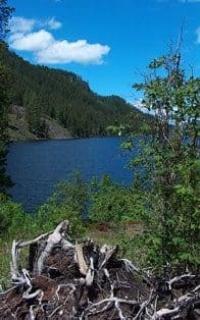
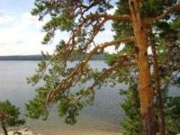
The upland landscapes of granite low mountains are very picturesque. A special beauty is given to them by “deep transparent lakes located at the foot of the mountains and the ruinous relief of weathered granite rocks forming bizarre statues and chaotic heaps ”(Gvozdetsky, Nikolaev, 1971, p. 152).
On the territory of the Kokshetau Upland, there are deposits of quartz-veined gold, iron ore, hard and brown coal, and others. In the region of the Kokshetau mountains there are deposits of noble metals and other ores, quarries for the extraction of mineral construction raw materials.
The climate is sharply continental, insufficiently humidified. The average annual precipitation is 300-390 mm, on the northern and western windward slopes up to 500 mm. the average July temperature is 17-18°C. Cold air masses often penetrate the West Siberian Plain to the Kokshetau Upland from the Kara Sea region.
The winter is cold, the average January temperature is -18°C, the minimum is 46°-48°C. Summer is moderately dry, warm, the average temperature in July is + 19 + 20°C, the maximum is up to + 42°C. Soils are mountain and forest and mountain chernozems.
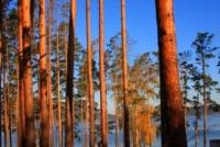
The Kokshetau upland is the only place in Kazakhstan where pine forests (relics of the Kokshetau upland) grow on a sphagnum bog. Long-term weathering processes led to the formation of exotic rocks known under the names: “Zhumbak-tas” (“Sphinx”), “Okzhetpes”, “Berkut”, etc.
Large rivers flowing within the Kokshetau Upland: Imanbulak, Arkanburluk, Zhylandy, Zhabay; lakes: Imantau, Zerenda, Borovoye, Shchuchye, etc. Numerous sanatoriums and rest houses are located on the shores of the lakes. The slopes are covered with pine forest.
In the depressions there are birch-aspen small-leaved forests. In the northern foothills there is forest-steppe and pine forests at rock outcrops, in the southern - forest-steppe and steppe areas. In the northwestern part of the hill there is the national park Kokshetau, in the western part there is the natural park Borovoe.
Lake, mountain and forest landscapes of the districts of Shchuchinsk - Borovoe, Zerenda and others are used for organizing tourism, recreation and treatment of workers. The Borovoye resort, located between the lakes Borovoye and Chebachy, enjoys all-Union fame.
Geographical coordinates of Kokshetau Upland: N52°48'47 E69°22'48
Authority:
Kokchetav upland. TSB "Great Soviet Encyclopedia" (in 30 volumes) ch. ed. A. M. Prokhorov. - 3rd edition. Moscow, "Soviet Encyclopedia", 1969 - 1978.
A. S. Biisenova, T.G. Smagulova. "Kazakh SSR", Concise Encyclopedia, Volume 2, 1989.
Gvozdetsky N.A., Golubchikov Yu.N. "Mountains", series "Nature of the World". Moscow, Thought, 1987.
Photos by:
Alexander Petrov.