


![]()
You are here
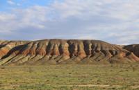
Ulanak Ridge on Mangyshlak.
Adventures in Mangyshlak.
“Willpower is the first and most important quality of a skilled researcher. Only by knowing how to control his will, he can hope to overcome the difficulties that nature raises in his path.
Amundsen Roald.
Sights of Kazakhstan.
The Ulanak ridge is located in the central part of the Mangyshlak peninsula, 4.5 kilometers northeast of the northern border of the South Aktau ridge, 3.5 kilometers southwest of the southern spurs of the West Aktau ridge in the Mangistau region of the region of the same name.
The Ulanak Ridge stretches for 11 years between the western spurs of the Western and Southern Aktau ridges. The western part of the ridge starts from the village of Zhangyldy, which is located on the highway between the villages of Shetpe and Taushyk.
In the southern part of the ridge there is an aquifer, in which there are 8 artesian wells. The length of the Ulanak Ridge from southeast to northwest is 18 kilometers, its width is insignificant - up to 1 kilometer. The highest elevation of the ridge in the western part is a nameless mountain with a height of 160.4 meters above sea level.
The next highest is also a nameless mountain with a height of 159.8 meters above sea level, which is located in the westernmost part of the mountains. In the northwestern part of the Ulanak Ridge, the famous valley of balls and the Torysh valley begins.
Geographical coordinates of Ulanak Ridge on Mangyshlak Peninsula: N44°14'21.25" E51°34'47.05"
Authority and photos by
Alexander Petrov.