


![]()
You are here
Turkestan ridge.
Tours to Turkestan ridge in Kyrgyzstan.
“The avalanche descended from the mountains -
Spring has come to the fields"
Swiss Highlanders saying.
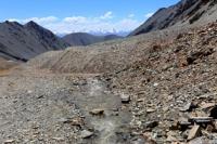
Traveling along mountain ranges of southern Kyrgyzstan.
The Turkestan ridge is located in the Gissar-Alai system, located on the territory of Kyrgyzstan, Tajikistan and Uzbekistan. Located between the Fergana and Zeravshan valleys, it is the western continuation of the Alay ridge.
The length of the Turkestan ridge is about 340 kilometers. Alpine relief prevails. In the eastern part, 35 peaks rise above 5000 meters above sea level, the highest is Skalisty Peak, 5621 meters above sea level. Other peaks - Ak-Su, 5335 meters above sea level, Petrograd, 5163 meters above sea level, Admiralteets, 5090 meters above sea level, Iskander, 5120 meters above sea level, Dostoevsky, 4974 meters above sea level, Aktyubek, 5125 meters above sea level, Alexandra Blok, 5229 meters above sea level, Karasu, 5309 meters above sea level, Usen, 4378 meters above sea level, Asan, 4230 meters above sea level, Ak-Su, 4925 meters above sea level, Pyramidal, 5509 meters above sea level, 1000 years of the baptism of Russia, 4507 meters above sea level, Ptitz, 4774 meters above sea level, Slesova, 4240 meters above sea level, Parus, 5037 meters above sea level, Yellow Wall, 3800 meters above sea level.
In the middle part, up to the Shahristan pass, 3378 meters above sea level, heights from 3200 to 4750 meters above sea level, to the west, to the Samarkand oasis, the height does not exceed 3200 meters above sea level.
The northern slope, reaching a width of 80 kilometers, is represented by parallel mountain ranges, ridges and ridges. The valleys and gorges are deep, narrow; on the northern slope, the height difference is from 2200 to 3500 meters above sea level with the length of the valleys from 5 to 40 kilometers.
The southern slope is steep and short, dissected by hanging narrow gorges with an altitude difference of 2500 to 4000 meters above sea level. The lower part of the northern slopes is covered with alpine steppe, arboreal and shrub vegetation, the southern slope is almost devoid of vegetation.
Above 4500 meters above sea level - nival landscapes. Through the Matcha mountain knot, the ridge joins the Alay ridge in the east, and extends to the Samarkand plain in the west. The Turkestan ridge has a height of more than 4000 meters above sea level for a considerable length.
The ridges and peaks of the Turkestan ridge lie in a zone of eternal snow, the border of which on the northern slope runs at an altitude of 3500 - 4000 meters above sea level. The northern slope of the Turkestan ridge is longer and gentle than the southern one.
Glaciers of Kshemysh, Shchurovsky, Minteke and others flow down from it. Almost all of them slide into deep gorges to the border of the forest. The southern slope of the Turkestan ridge is steeper, shorter and heavily dissected by rocky steep ridges.
Glaciers of Skachkov, Tolstov, Farakhnou and others are located between them. All of them merge with the huge flow of the Zeravshan glacier and carry masses of debris. The northern slope is long and gentle, with juniper forests and woodlands, the southern one is short and steep with rocks and talus.
From the south, the valley of the Zeravshan River is separated from the Zeravshan Range. The ridge, especially in the eastern part, is covered with mountain glaciers. The largest are the Tolstoy, Shurovsky and Zeravshan glaciers - the source of the Zeravshan River.
The Dushanbe-Khujand highway passes through one of the passes of the ridge - Shakhristan at an altitude of 3378 meters above sea level. The slopes are dissected by the valleys of the Isfara, Ak-Suu, Kara-Suu rivers.
On the northern slope there is a mountain lake Ai-Kel. The border of Tajikistan with Uzbekistan and Kyrgyzstan runs along the ridge. Administratively located in Batken region. The total area of glaciation is about 600 square kilometers.
The height of the firn line on the northern slopes ranges from 3500 to 4000 meters above sea level, on the southern slopes - about 4500 meters above sea level. There are more than 80 passes in the Turkestan ridge with a height of 3500 to 5150 meters above sea level.
In the spurs of the northern slope of the Turkestan ridge, there is the Zaamin reserve.
The most significant parts of the Turkestan ridge:
The middle section of the Turkestan ridge, length 180 kilometers, height from 2350 to 4750 meters above sea level. Direction - east - west.
Eastern section of the Turkestan ridge, length 50 kilometers, height from 2500 to 5621 meters above sea level. Direction - north, northwest, east - west.
Authority:
The book "Soviet Encyclopedia". Mountaineering regions of Kyrgyzstan, guide, author Vladimir Komissarov. Bishkek city, 2010
Photos by
Alexander Petrov.