


![]()
You are here
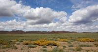
Turgai hollow.
Natural sights of Kostanay region.
“I would also like to add that every time I returned from the steppe hike to my home in Orenburg, I felt cramped, it seemed that I didn’t have enough air. This feeling, which eventually passes, encompasses everyone who breathed for a long time clean, steppe air, slept in a wagon or right on the ground and for whom the boundless steppe served as the horizon. Only gradually you get used to the firm, roomy air"
Ivan Fedorovich Blaramberga. 1840 – 1855.
Excursions in nature of Kostanay region.
Turgai Valley (Turgai Hollow) is an erosion-tectonic hollow located in Kostanay, Aktobe, Karaganda, Akmola regions of Kazakhstan. Northern part of hollow is located in Orenburg region of Russia. Hollow is traced in relief from lower reaches of Tavda River in north to Northern Aral Sea region in south.
Crosses the Turgai plateau from south to north. It connects the West Siberian Plain with the northern part of the Turan Lowland in Kazakhstan. The rivers Turgai, Ubagan, Tobol flow along the Turgai hollow. There are many lakes in the valley.
Absolute heights - 100 - 125 meters above sea level. To the west and east of the Turgai hollow, the heights increase to 200, sometimes up to 300 m.
A chain of numerous lakes stretches along the hollow with a large lake Kushmurun in the north, into which the Ubagan river flows, in the south the Turgai river flows along the hollow. The length is about 630 or 800 kilometers, the width is from 20 - 75 to 300 kilometers.
Prevailing heights up to 125 and 200 - 300 meters above sea level. In the north - dry steppes (the area of development of virgin and fallow lands), in the south - semi-deserts and deserts Barsuki Big and Small Barsuki. The Naurzum reserve is located in the valley.
Along the Turgai Hollow in the Pliocene and Pleistocene, the Turan Sea in certain periods was connected with the West Siberian Sea. As a morphologically pronounced element in the relief of Western Siberia, the Turgai Hollow begins to be traced slightly south of 58 ° N. sh. - from the lower reaches of the Tavda River.
To the north of the latter, the bottom of the hollow merges with the surface of the Kondinskaya lowland, forming a single geomorphological level with it. The eastern bedrock slope of the hollow continues further north, up to the latitudinal section of the Ob.
It is a high (up to 40 - 60 meters), steep ledge of the Tobolsk continent upland, breaking off to the Kondinskaya lowland. To the south, from the lower reaches of the Tavda to the mouth of the Ubagan River, for about 400 km, the pattern of the hollow resembles a classic lineament.
In this area, the contour of the hollow is perceived as a huge furrow laid in the southern part of the West Siberian Plain. In the west, between the Trans-Ural peneplain and the hollow, is the Kustanai-Miass plain. It is generally inclined to the north with a slight bias in the northeastern direction, towards the Kondinskaya lowland and the Tobolsk continent.
According to the slope of the absolute elevation, the surface of the plains decreases from 230 to 150 m. a. s. l. To the east of the hollow, to the north of the Kazakh Shield, there is a system of stepped plains, successively articulating to each other.
The northernmost of them is represented by the Tobolsk mainland with absolute elevations of 90 - 130 m. a. s. l. The Ishim Plain with a slight slope of the surface to the north from 180 to 150 meters corresponds to the middle step. The southern step, with a slope in the same direction from 220 to 200 m, is the Tyuntyugur plain. In the strip of 52 ° N. sh. she is leaning against the Turgai plateau.
The plateau is located at the site of the closest approach of the structures of the Urals and the Kazakh Shield, between 48 ° N. sh. and 52 ° N. sh. In the system of the Ural-Tien Shan Epigercyn Platform, this territory corresponds to the Turgai Trough, which is a link between the structures of the West Siberian and Turanian plates.
From the source of the Ubagan River to Lake Kuyukkul, already within the Turgai plateau, for about 150 kilometers, the hollow has a strictly meridional strike. Its relatively narrow part, 22 - 25 kilometers wide, is confined to the same area. The transverse profile of the trough in this area has a trough-like shape.
The modern bottom of the hollow, which lies at absolute elevations of 120 - 130 meters, is limited by relatively high (60 - 80 meters) slopes. The ancient thalweg of the hollow is buried under 70 - 90 meters of Quaternary sediments. is he is located here at absolute elevations of 30 - 40 meters.
The current bottom of the hollow in this part is not currently drained by rivers. It is this part of the hollow that is called the "Turgai gate" or "the dead Ubago-Turgai hollow". This section of the hollow corresponds to the intra-gulf watershed separating the rivers of the Irtysh basin (Ubagan, the middle and lower reaches of the Tobol) from the rivers of the Turgai closed basin.
The intra-gulf watershed and adjacent sections of the bottom of the hollow abound in morphologically weakly isolated lowlands, the lowest parts of which are occupied by large lakes - Kushmurun (465 sq. km.), Sarykopa (336 sq. km.), Aksuat (123 square kilometers), Saramoin (126 sq. km.) and others.
These lakes are the recipients of small steppe rivers flowing from the sides of the hollow and the ephemeral spring runoff formed by the melting of snow in the bottom of the hollow itself. South of 50 ° N. sh. the hollow enters the contours of the South Turgai Plain.
The hollow here noticeably loses its "face", which is characteristic of its more northern parts. The morphological severity of the hollow is significantly reduced. This phenomenon is associated, on the one hand, with the small values of the absolute heights (140 - 180 meters) of the levels of the Pleistocene pediplains associated with the trough, and on the other hand, with the large width of the bottom of the trough.
At the latitude level of the basin of Lake Sarykopa, the width of the depression reaches about 50 kilometers. From the mouth of the Saryozen River, the strike of the hollow changes to the southwest. Its bottom is drained here by Turgai. The hollow retains its southwestern direction for almost 200 kilometers, until it merges with the Irgiz River valley.
Before merging with the Irgiz, Turgai forms a vast intra-valley delta. The frontal part of the delta is cut off by a latitudinal segment of the lower course of the Irgiz, the direction of which is also acquired by the Turgai before drying up in the vast, shallow depression of the Teniz Saline land.
The southern extension of the hollow from Irgiz to the Aral Sea is devoid of runoff. The modern bottom of this dead part of the hollow, about 200 kilometers long, is cut into the surface of flat-topped table remnants (pre-Pleistocene pediplains) of the Northern Aral Sea region to a depth of 120 - 150 meters.
The contours of the hollow here become indistinct and practically not expressed in the relief. In the Turgai trough, large deposits of magnetite iron ores (Kacharskoe, Sokolovskoe, Sarbayskoe, Kurzhunkolskoe) and phosphorous brown iron ores (Ayatskoe, Lisakovskoe), as well as bauxites (the largest is the Arkalykskoe deposit) were discovered, large reserves of coal were discovered (Ubaganskoe basin).
In the western part of the hollow, the West Turgai nickel region is located. In the Turgai Valley, the so-called Turgai or Indricotherium fauna was first discovered - a complex of extinct animals that inhabited the temperate zone of Eurasia in the Middle Oligocene (from China to the Balkan Peninsula).
Authority:
https://ru.wikipedia.org/wiki
Photos by:
Alexander Petrov.