


![]()
You are here
Trip to depression of Zhigylgan.


Trip from Aktau to Kysdykary lake.
“When you travel without knowing English, you begin to understand what it means to be born deaf and dumb”
Philip Bouvard.
Short description of route of a sightseeing trip from Aktau to Sultan Epe mosque:
Aktau - Akshukyr village - Kashkar-Ata necropolis - Blue Bay on Caspian - Devil's finger on Aktau - Karagash necropolis - Caspian Sea - Zhygylgan depression - Lake Kuzdakary - Ushtam necropolis - underground mosque and canyon Sultan Epe - Aktau.
Distance of route: 288 km.
Distance of active part: 4 km.
Season: April - October.
Duration: 1 day.
Best time for tour: April, May, June, September.
Detailed travel program for Blue Bay on Caspian Sea:
Trip to necropolis of Kenty Baba.
Transfer: Aktau - Akshukyr village (20 km). Our way from Aktau lies north in the direction of the city of Fort Shevchenko, in the village of Akshukyr visit the necropolis of Kashkar-Ata. On the Kashkar-Ata necropolis, a characteristic type of monuments are various types of tombs of the Koytas type, tombstones of small sizes, usually devoid of decorative processing. At the ends and sides, tamgas and arabographic epitaphs are carved. Walk along the necropolis.
Transfer: Kashkar-Ata necropolis - Devil's finger (Uzunkudyk) on the eastern coast of the Caspian Sea (59 km). At 69 kilometers after Aktau, we turn left to the shore of the Caspian Sea from here to the cliff on the seashore 10 kilometers. The lonely rock Devil's Finger is located on the eastern coast of the Caspian Sea in the Tupkaragan region of the Mangistau region. The coast in the vicinity of the cliff is very picturesque, there are bizarre rocks treated with water and wind, a delightful coast with a large, multi-colored shell and clear emerald water.
Walking in the Blue Bay (560 m). There is a charming, sandy small sea bay, 546 meters long from south to north and 123 meters wide, the bay is formed by the converging mouths of the canyons of Tulkili and Uzynkudyk.
Transfer: Blue Bay - Karagash necropolis (44 km). Walk around the necropolis.
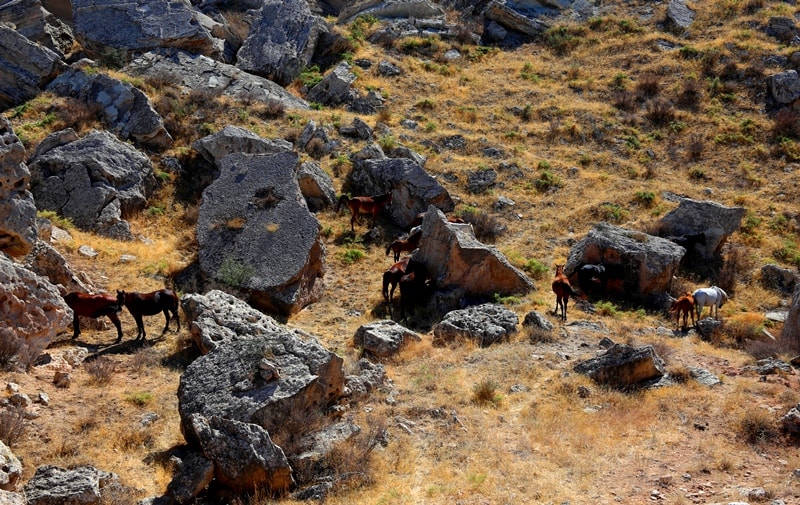
Transfer: Karagash necropolis - Buzyktam necropolis - Zhayylgan lambing barn - Danyshpan valley - Caspian Sea (19 km). After the Karagash necropolis, our path lies northwest to the cliff edge, from where, in the north, we will see the blue water surface of the Caspian. A steppe road goes down to the coast, we pass the ruins of the fishing village of Zhayylgan and soon we are on the seashore. To the north-east of us is Cape Zhygalgan. Walk around.
Transfer: tract Danyspan - depression Zhygylgan (8 km).
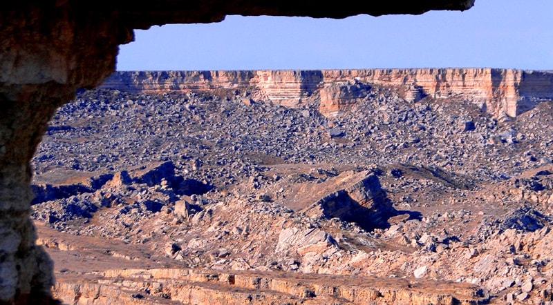
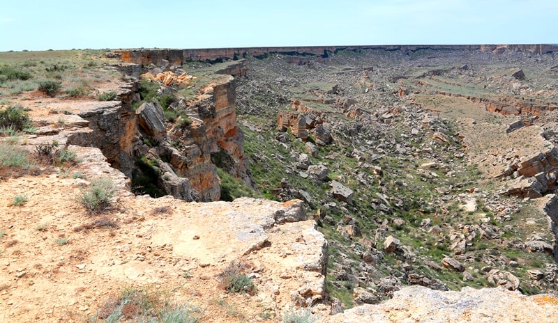
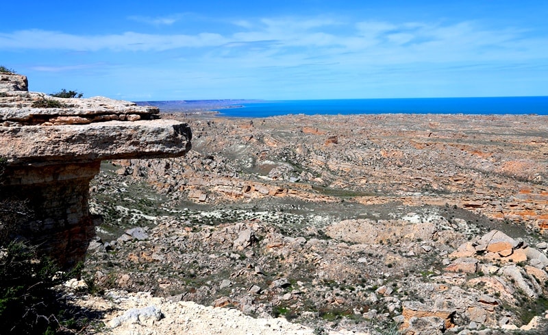
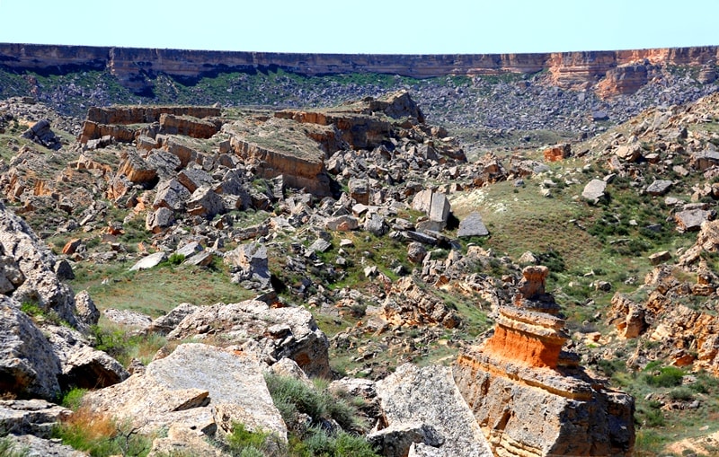
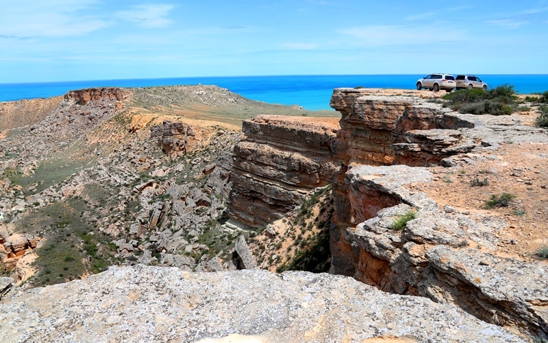
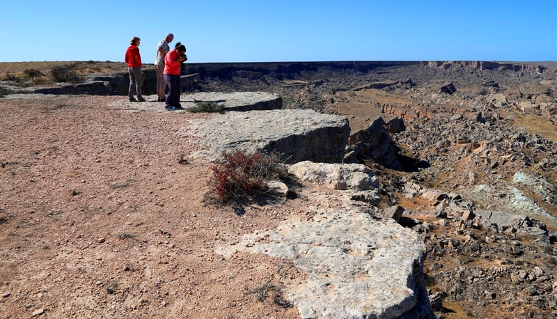
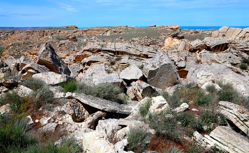
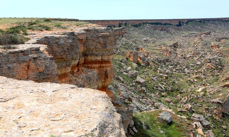
After a walk by the sea, we climb the cliff and move east along the edge of the cliff from which magnificent panoramas of the western part of Cape Zhygylgan open. After 5 kilometers, the Zhygylgan failure begins. Failure Zhygylgan (translated from Kazakh - "Fallen Land") is located in the north-eastern part of the Tupkaragan Peninsula.
At the point of descent from cliff to the basin, the height above sea level is 157.8 meters, and the coastal part in the vicinity of Cape Zhygylgan is only 5.3 meters above sea level. 150 meters in height is the height difference in the dip.
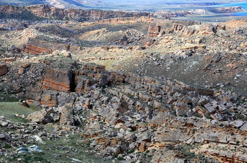
The length of the Zhigylgan dip from north to south from the cliff edge and to the western end of Cape Zhigylgan is 4 kilometers 254 meters, the largest width from west to east is 2.7 kilometers. The circumference of the dip is almost 12 kilometers.
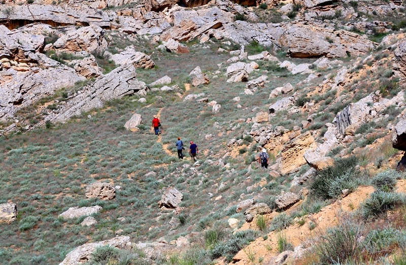
Hiking: depression Zhigylgan - descent from the cliff - traces of prehistoric animals (1 km). In paleontology, the bones of the three-toed ancestors of the horse (meryhypus) and saber-toothed cats (makhairodov) are well known, rarely anyone has seen traces of these animals. Zhigylgan gave people a rare opportunity to contemplate an extraordinary sight - fragments of plates with prints on their surface of petrified traces of large and small cats and deeply bogged down hoofs with two bone processes from behind, small horses. Walk around.
Hiking: traces of prehistoric animals - Lake Kuzdakary (1 km). Kuzdakary Lake is located at an altitude of 5.3 meters above sea level and connects via underground channels to the Caspian Sea. The closest distance from the shore of the Caspian to the lake is 720 meters.
The length of the lake from north to south is 87 meters; the width from east to west is 54 meters. The distance from the descent from cliff to the dip and further to the lake is two kilometers along a good path. In the western part of the lake there is a small elongated pond of the meridional direction, which is filled with water in the spring and dries in June.
The water in the lake is bitterly saline, not suitable for drinking. Walk around. Return to cliff. Lunch.
Transfer: Zhygylgan depression - Saganazhyksay valley - Borly valley - Ushtam necropolis (23 km). The Ushtam necropolis dates from the Xth - XVIth centuries; here there are very interesting tombstones. The Ushtam necropolis has a low fence, it is a tribal crypt, there are three tombstones here - a XIVth-century domed mausoleum, a madrasah and a mosque. Turkmen mausoleums still retain the classical correctness of forms, composed of massive yellowish limestone blocks, about 6 meters high. Walk around the necropolis.
Transfer: Ushtam necropolis - Kenty Baba necropolis (3 km). On the territory of the necropolis of Kenty Baba there are memorials of the XVth - XXth centuries. Such monuments are almost never found anywhere else. The original shape of the mausoleum is trapezoidal, without a dome, 8 meters high, an ornament is at the top and bottom of the parapet. Walk along the necropolis.
Transfer: Kente Baba necropolis - underground mosque and canyon Sultan Epe (1.5 km).
The Sultan Epe underground mosque was built within the walls of a shallow channel, formed by washing and destruction by flood waters of a rock formation up to 2 meters thick, lying on a layer of marly clay, which determine the whole system of Neogene deposits. The mosque consists of 9 rooms. The entrance to the underground part of the mosque leads from a covered narrow room located in the southwestern part of the channel. Visit to the mosque and necropolis.
Walk to the canyon Sultan Epe. Sultan Epe canyon is the only coastal canyon that nature has endowed with the ability to unexpectedly delight the traveler’s eye with a green palette of colors. The slopes of the canyon are covered with groves of tree vegetation, where hawthorn, mulberry, willow and dzhigida are adjacent.
Transfer: canyon Sultan Epe - Aktau (108 km). Arrival in Aktau, the end of the tour.
Note:
Author program of Alexander Petrov. Copying and introduction - from the sanction of the author petrovsra@mail.ru
Photos by
Alexander Petrov