


![]()
You are here
Trip to cliffs valley Akzhar.

Group Hiking Tours in Ulytau.
“Why do you go away? So that you can come back. So that you can see the place you came from with new eyes and extra colors. And the people there see you differently, too. Coming back to where you started is not the same as never leaving”
Terry Pratchett. “A Hat Full of Sky”.
Short description of tour program to cliffs valley Akzhar in Kostanay region:
Zhezkazgan town - Terekty petroglyphs - Zhezdy village - Ayakkamyr ancient settlement - Beskamyr ancient settlement - Ulytau settlement - Akzhar cliffs - Zhezkazgan town.
Distance of route: 771 km.
Season: May - September.
Length of hiking part of the tour: 2 km.
Duration: 6 days, 5 nights.
Best time for tour: June - August.
Detailed program of excursion tour from Ulytau to Kostanay region:
Walking Routes Around Zhezkazgan.
Day 1. Zhezkazgan - Terekty rock paintings (188 km).
City Tour. There are two museums in the town. Visit to the Historical and Industrial Museum named after K.I. Satpayeva. The museum's halls display about 2,000 exhibits and a very rich geological collection.
The museum's archival fund stores materials on the history of the Bronze Age in the Zhezkazgan-Ulytau region, on the history of the exploration and development of the Zhezkazgan copper deposit, about the Zhezkazgan plant and its people; documents, personal belongings of famous personalities, Academician K.I. Satpayev and others. Visit to the monument to K. Satpayev located opposite the museum.
Visit to the Zhezkazgan Historical and Archaeological Museum. The museum's exhibitions are housed in four halls: paleontology, nature, archeology and ethnography "Pearl of Saryarka". Visiting the town park of culture and recreation named after 30 years of Victory, Metallurgists Square, the monument to the Metallurgists, the monument to the First Builders of the town, the monument to the space explorers, the monument to Abylai Khan, the monument to Sarbaz rebels, the monument to Dzhezkazgan soldiers who died in the Great Patriotic War, the Church of St. Apostle Andrew the First-Called, Cosmonauts Boulevard.
Transfer: Zhezkazgan – Terekty village – Terekty rock paintings (94 km).
The historical and archaeological complex of Terekty-Aulie consists of a gallery of rock paintings - a Neolithic site, settlements and necropolises of the Bronze Age, mounds of the early Iron Age, the remains of horizontal and vertical adits in which ores and semi-precious minerals were mined, and mazars of the XIXth century.
The Terekty petroglyphs are located on the tops of three granite hills, stretched in a chain from west to east. Images of animals are carved on the stones, which can be attributed to the Saka animal style, the Bronze Age (IIIrd - Ist millennium BC), Early Iron Age (IXth century BC - IIIrd century AD) and to the Middle Ages.
Walks in the surrounding area, visiting rock paintings, necropolis and mazars of the XIXth century. End of the excursion, return to Zhezkazgan, transfer to the hotel, overnight.
Day 2. Zhezkazgan town– Ulytau village (131 km).
Breakfast. Transfer: Zhezkazgan – Zlatoust-Belovsky quarry – Zhezdy village (47 km).
After we pass the city, our path lies to the city of Satpayev, which is located 21 kilometers from Zhezkazgan. After Satpayev we pass the industrial zone and our path goes northwest to the village of Zhezdy.
Arrival in the village of Zhezdy, visit to the Museum of the History of Mining and Smelting. The Museum of the History of Mining and Smelting in the village of Zhezdy was opened on July 15, 1994. Mining equipment from different times is located in the open air on an area of 3 hectares, also in the exposition and exhibition halls of the museum.
The museum's fund consists of more than 15,000 exhibits covering the history of mining and smelting, material culture, ethnography and the life of the people. The museum shows history from the Paleolithic to modern times.
Transfer: Zhezdy village - Ayakkamyr settlement (16 km).
The ancient settlement of Ayakkamyr is located in the western part of the ancient necropolis; it is a strongly eroded square mound. On The settlement has a ditch on three sides; on the fourth southwestern side, the remains of structures in the form of heavily eroded elongated mounds and stone walls adjoin the settlement.
350 meters from the settlement to the west is the mausoleum of Kutluk-Temir (Ayakkamyr). The mausoleum is made of baked bricks. According to the assumption of A. Kh. Margulan, the mausoleum was built as the tomb of Genghisid Kutlug-Temir. The mausoleum is surrounded by a late medieval necropolis. Walk in the vicinity of the ancient settlement and mausoleum.
Transfer: Ayakkamyr ancient settlement (Kutluk-Temir mausoleum) - Karabulak tract - Baskamyr ancient settlement (14 km).
The Baskamyr settlement is the remains of a medieval castle, surrounded by three powerful walls with a citadel and flanking towers. Researchers date Baskamyr to the VIIIth - XIth centuries. The settlement is associated with the construction activities of the Kipchaks. A walk in the vicinity of the ancient settlement and archaeological excavations of a Bronze Age settlement.
Transfer: Beskamyr ancient settlement – monument “Unity of the Peoples of Kazakhstan” (44 km).
The monument to the unity and cohesion of the Kazakh people on the slope of Mount Aiyrtau was erected in 1992. The monument is the geographical center of Kazakhstan. The sculptural composition represents the four cardinal directions.
Transfer: monument “Unity of the Peoples of Kazakhstan” - Ulytau village (10 km). Arrival in the village of Ulytau, transfer to a guest house, accommodation, dinner, overnight.
Day 3. Ulytau village – Akzhar cliffs (130 km).
Breakfast. Transfer: Ulytau village – Korgasyn village (91 km).
Our path from the village of Ulytau to Korgasyn lies to the northwest. The village of Korgasyn is located on the right bank of the Karatorgai River, also has a second name - Shenber, is the center of the Shenber rural district and one of the largest settlements in the northern part of the Ulytau region.
The village arose in the XIXth century near the lead deposit, Korgasyn (Kazakh - lead). Near the village you can visit the mines of an old mine, English houses, of which there are several in the village. The thickness of the walls of the house, which is located in the northern part of the village, near an abandoned mine, is about a meter; in general, the house is made in a manner unusual for local architecture. In the northern part of the village there is the mazar of Dabey Begenuly (Sherapai Mankin).
The history of lead mines near the village of Korgasyn dates back to the beginning of the XIXth century. A rich deposit of lead in these places was discovered following the traces of ancient workings in 1813 (according to another version - in 1815) by mining surveyor Herman.
There is excellent drinking water at the pumps in the village; here you can replenish your supplies before heading to the waterless steppe. In the village, there is also Internet and mobile communications, there is a store, but there is no bread.
Transfer: Korgasyn village – Zhakuda Ishan mosque (19 km).
The mosque, which, among other things, housed a madrasah, was built in the second half of the 19th century. The walls of the mosque, as well as the minaret, have survived to this day; the roof is missing.
The building has been restored several times. The mosque is located in a picturesque location near the water in the valley of the Terisbutak River. 130 meters northwest of the mosque there is an ancient necropolis. The mosque is surrounded by a metal fence.
Transfer: Zhakuda Ishan Mosque – southern tip of the Akzhar cliffs (20 km).
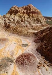
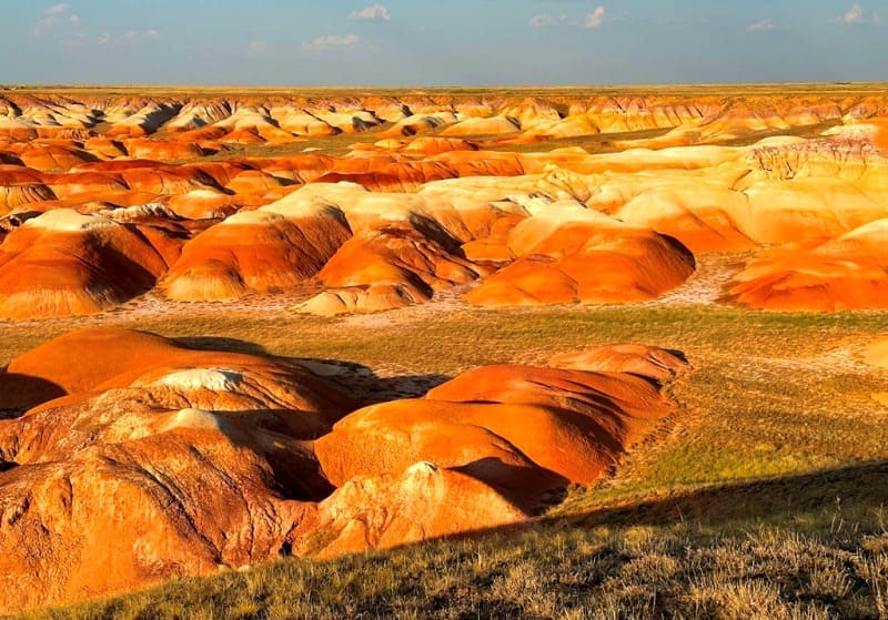
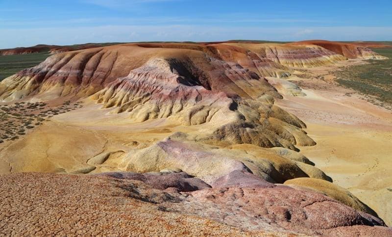
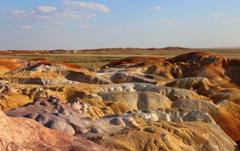
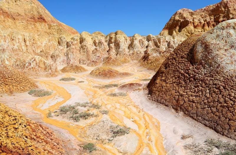
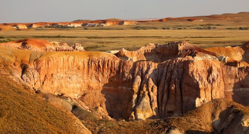
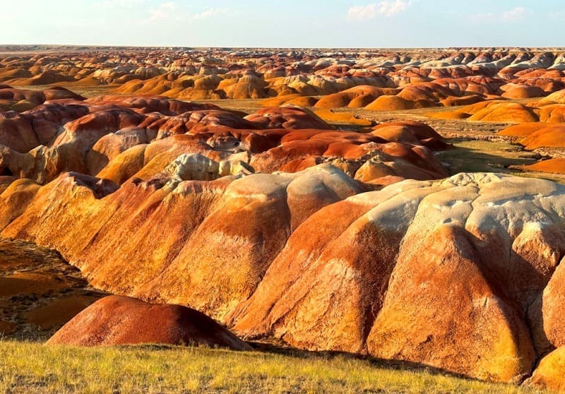
We will set up our tent camp in a picturesque place among the colorful clays of the southern tip of the Akzhar cliffs. Cliffs Akzhar consists of layers of sedimentary rocks with magnificent shapes and different colors of the soil. At sunrise and sunset, incredible views of the surrounding area open up. Dinner, overnight in tents.
Day 4 Transfer: southern end of Akzhar cliffs – central Akzhar cliffs (22 km).
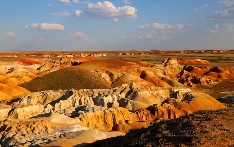
Breakfast. Our path from the southern tip of the cliffs lies to the northwest; we move along the eastern edge of the cliffs, which are located on the right bank of the Karatorgai. The road either approaches the very edge of the cliffs, where picturesque multi-colored clays are located, or moves away, passing ravines.
Soon we are in the central part of the Akzhar cliffs. To the north, east, and west of our camp there are fantastic, out-of-this-world panoramas of the surrounding nature, which shares with us its unprecedented colors and secrets. Walks in the surrounding area. Lunch, dinner, overnight in tents.
Day 5 Central cliffs of Akzhar.
Breakfast, lunch, dinner, walks in the surrounding area, overnight in tents.
Day 6 Transfer: central cliffs Akzhar – Zhezkazgan (300 km).
Breakfast. Lunch on the way. Arrival in Zhezkazgan, end of the trip.
Note:
Author program of Alexander Petrov. Copying and introduction - from the sanction of the author.
Alexander Petrov
Photos by: