


![]()
You are here
Towns Kasbah and Bazda in Nahshaba.
Excursions in Kashkadarya region.
“I think the story will be favorable to me, because I'm going to write it myself”
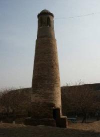
Photo tours in Kashkadarya region.
In the region of Nahshab from the early Middle Ages there were two major cities - Kasbah and Bazda. The first of them is mentioned in Armenian sources in the 5th century. as "strong fortress of Kazbion". According to Sebeos, the Persian commander Vahram Mihrevandak, (Bahram Chubin), conquered Balkh and the entire “Kushan Country”, located on the other side of the big river Vekhrot, i.e. Amu Darya, right up to the place named Kazbion. E. V. Retveladze identifies Kazbion with the mountainous region of Gabaz or Gazab of ancient sources and localizes it between Darband, i.e. the Iron Gate, and Guzar.
According to him, the border of the Kushan state to the north of the Amu Darya was a fortress wall built in the first centuries AD. er in the Shurobsay valley near the Iron Gate, and immediately after them began the mountain region of Kazbion-Gazab.
It is possible that the fortress Kasbah-Kazbion was intended to protect the western borders of this mountainous region. At the end of 589, the Sassanian commander Bahram Chubin, defeating the Turks, conquered this fortress and turned it into an outpost of the Sassanids on the border with the Turks.
In the X century. The city of Kasbah, according to sources, exceeded even the capital city of Nasaf in size, and had a cathedral mosque that functioned in the 12th century. The medieval town of Kasbah was a major trading center, as an important caravan route passed through it, passing from Bukhara to Termez bypassing Nasaf.
In the vicinity of the city were developed agricultural farms. In the XII century. al-Samani calls the Kasbah a “village”. The village of Kasbi is also mentioned in the sources of the post-Mongolian time. In the XVII century. it was inhabited by the ancient Sayid family.
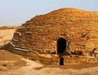
The village of Kasbi also exists today, 30 km south-west of the site Shullyuktepa and 35 km from Karshi. On the outskirts of the village there is an extensive medieval settlement Kasbitepa (180 x 120 m.), Which was the citadel of the pre-Mongol city Kasb or Kasbi.
The lowest archaeological layers of the settlement date from the first centuries AD. The early medieval fortress Kazbion of Armenian sources is also localized here. B IX - XII century. The fortress was surrounded by Shahristan, behind the walls of which were extensive Rabadas stretching almost southeast to the southeast.
Kasbah is one of the few cities of Sogd, which continued to develop after the Mongol invasion in the same place. According to actual data, the medieval Kasbah in the X century. really outnumbered Nasaf. A large complex of mausoleums of the XIth - XIIth centuries, known as Sultan Mir Haidar, has been preserved in the village of Kasbi.
The second major city in the area of medieval Nasaf was the city of Bazda, which also existed since the early medieval era. In sources IX - X century. He is mentioned along with Kasbah as one of the two cities of the Nasaf region, which had a cathedral mosque. According to some information, in the X century.
It is in size, like Kasbah, superior to the capital city of Nasaf. In the XII century. al-Sam'ani mentions Bazda as an “impregnable fortress” located on the way from Nasaf to Bukhara. The medieval city of Bazda, as well as the Kasbah, was a major trading center, as it was located on an important caravan route that went from Nasaf and the Kalif to Bukhara.
Despite the scarcity of water sources, agriculture was developed in the vicinity of the city. For the irrigation of fields, the inhabitants of the city used the water of wells, since the only river that was nearby, dried up most of the year.
The Medieval Bazda is located in the Kunya-Fazli town, located at a distance of 40 km south-west of the site Shulyuktep and 10 km south-west of the village of Kamapsh. The city consisted of a citadel (150 x 100 m), a shahristan surrounded by a fortification (55 hectares) and a rabad.
The lowest archaeological layers of the base of the base are the first centuries AD. Bazda and Kasbah were in the Middle Ages strategically important fortresses, located on the borders of the oasis of the lower reaches of Kashkadarya.
Both fortresses were located on hills at a distance of 20 km from each other and, despite the distance, from the top of one of them the top of the other was visible. In antiquity they were probably built in the interests of the defense of the Karshi oasis from nomads.
Therefore, not by chance in the VI. Sasanian commander Bahram Chubin chose Kasbah, not Nahshab, for the outpost of his army. North of Bazda on the caravan route from Bukhara to the Kalif passing Nasaf, in sources of the 10th century. three intermediate stations are mentioned: Jikim, Rabat 'Atik, i.e. Old Rabat, and Jubb Sa'id - that is, the Sa'id Well.
All of them were located at a distance of one transition from each other between Bukhara and Bazda. Of these, the Old Rabat and the Well of Sa'ida are perhaps more The Nasaf area. On this section of the route between the Kunya-Fazli fortified settlement and Mubarek there are two major monuments of the IXth - Xth centuries. - the Kosh Rabat fortress, located to the west of Pamuk, and the Kyzyltepa fortress, located 8 km south-east of Pamuk.
Both of these monuments were fortified rabat functioning in the IXth - Xth centuries, under the protection of which caravans stopped. Of these, “Old Rabat” probably corresponds to Koshrabat, and “Sa'id's Well” - Kyzyltepa with the settlement of the IXth - Xth centuries adjacent to it from the north.
In the area of medieval Nasaf, there was another city called Gubdin. In sources IX - X century. He is not mentioned, but his name was worn by one of the city gates Nasaf. This indicates that this gate went out on the caravan route leading to the important trade and artisan center. In the XII century.
Al-Sam'ani mentions the village of Gubdin, located at a distance of two farces from Nasaf, and the rustak of Gubdin, which was the village of Batkhudan or Butkhazan and Khuziyan castle. It should be borne in mind that al-Sam'ani calls almost all the settlements located in the area of large cities “villages”, even such a large city as Kasbah.
Thus, all the data show that in the epoch before the Mongol invasion, Gubdin was a significant city and the administrative center of a special village located on the way from Nasaf to Kalif. In the sources of the post-Mongolian time, Gubdin is also mentioned as a village, and a separate fog. In the XV - XVII centuries.
The name “Gubdin” also bore a channel in the Nasaf area. The village of Gubdin still exists and is located 20 km from the city of Beshkent, to the west of Karshi. Near the village of Gubdin there is a large medieval settlement of Tallissortepa (13 hectares), which is identified with the medieval city of Gubdin.
The city consisted of a citadel, shahristan and rabad. The settlement on the site of the citadel arose in the first centuries AD. e., which later began to grow. In VI - VII century. Shahristan reached the largest size and was surrounded by a fortress wall with three gates.
The unfortified rabad began to be settled in the 9th century, and in the 10-12th centuries. the center of city life has moved here. Rabad Gubdin, who occupied an area of about 20 hectares, continued to partially settle down after the Mongol conquest.
According to the latest data, the territory occupied by the rabad of medieval Gubdin reached almost 50 hectares. During the excavations, a piece of charred carved wood was found on the territory of the Gubdin citadel, which dates from the VIIth - VIIIth centuries.
It depicted a portrait of a nobleman with Turkic features, who may have been the ruler of Gubdin in the period on the eve of the Arab conquest. It should be noted that in the early Middle Ages, the use of carved wood in the architectural decoration of buildings was typical mainly for cities.
In the vakfny documents of the XV - XVI century. in the Nasaf area, the Khudiyan channel and the Khudiyan Rabat lands are mentioned. We must assume that the latter, that is, the Khudiyan Rabat, is mentioned in the 12th century. as the Khuziyan castle, which was located in the Gubdin rustak.
Firdousi also mentioned the toponym Khuziyan in “Shakhname”, but it is difficult to say whether it belongs to the Khuziyan castle or not. The name of the village Batkhudan or Butkhazan, also located in the XII century. in Rustak, Gubdin is probably connected with a Buddhist temple, judging by the presence in it of the words “boot”, that is, idol, and “hudah” or “make up”, that is, deity. It is known that in the period of the early Middle Ages Buddhism was partly spread in Sogd, which, apparently, was due to the domination of the Turks here.
In "Shahname" Firdousi in the story of the events that took place in the V century. n e., the toponym Maimurg is mentioned as a terminal point in Sogd, which was reached by the Sassanian commander Bahram Chubin during his campaign against the Khakan Chin.
Sources IX - X centuries. Two points are mentioned with the name Maymurg. The first of them belonged to Rustaq, located to the south-east of Samarkand, and the second to a small town (“noodle”), which was the first intermediate station on the way from Nasaf to Bukhara.
There is an opinion that in “Shahname” Firdousi, most likely, it is a question of the second, i.e. Nachshabek Maymurg. In the XII century. Al-Sam'ani calls Maymurg “a big and beautiful village”. Al-Sam'ani’s work mentions another, third Maymurg, which was located on the banks of the Amu Darya in the Termez region.
The name of Maymurg is derived from the Sogdian words “lane”, i.e. the settlement, and “murg”, i.e. grass, meadow, and means “a village rich in meadows”. The Maimanaktepa site of ancient settlement, located 15 km north-west of Kasaan, probably corresponds to Nakhshabskiy Maymurgu.
Until the beginning of the XX century. The fortress (120 x 120 m) functioned here, in which pottery of the X-XII century was found. medieval Nasaf to Maymurg indicated in the sources. The village of Maymurg in the region of Nakhshab is also mentioned in “Abdullanam”.
In the XVI century. here was a hunting reserve that was located represent more monumental buildings. These cities, apparently, also include some medieval villages, whose names include the Sogdian word “kas” meaning fortress, village or city.
In the geographical composition of al-Mukaddasi, the city of Syrakas is mentioned along with Kasba and Bazda among the cities of the Nasaf region. In the XII century. Al-Sam'ani mentions the village of Shirakas in the region of Nasaf, and in another place of his work he names the village of Sarkas and classifies it in the region of Kesh.
If we assume that both authors meant the same point, then Shirkas or Sirkas should have been somewhere on the border between the Nasaf area and the Kesh area, that is, in the middle Kashkadarya. Here, in the area of the Chimkurgan reservoir, there are several sites of ancient settlements, which date from the early and developed Middle Ages. These include Kurgantepa, Chimkurgantepa, Buritepa, Kyztepa, Yalpaktepa, Sarytepa I and Sarytepa II.
Of all these names of the sites, the last two - Sarytepa I and Sarytepa II draw attention to themselves. It should be stated that this name is not associated with the Türkic word “Saryk”, that is, yellow, because just upstream of the Kashkadarya river there is another settlement with this name - Sarytepa. It can be assumed that the name Saryktepa reflects the ancient name of the city, which is referred to in the sources as Syrakas or Shirakas.
The site of Sarytep I was located in the flood zone of the Chimkurgan reservoir, near the village of Kaiky, which got its name from the ferry that once existed on the left bank of the floodplain of Kashkadarya. The settlement was surrounded by a fortress wall and a moat and occupied an area of about 4.5 hectares. The lower archaeological layers of it belong to the V - VII century, and the upper - XI - XII century. A terracotta model of a monumental building that had a dome and towers was found here.
The site of Sarytepa II is located two kilometers southeast of the dam, on the southern shore of the Chimkurgan reservoir. The earliest archaeological layers of it belong to the III-V centuries. AD, and later - to the IX - XII centuries. The remains of a home sanctuary with an altar were found here in a residential building that functioned in the 8th-9th centuries, and a terracotta hollow inside head of an idol in the shape of a ball with Turkic features was found.
In the XII century. al-Sam'ani mentions another settlement in the Nasaf area, in the name of which the Sogdian word “kas” is added - Fijakas. In the vakf documents of the XV - XVI centuries. the villages of Kat Pudirkat, Vanakat Pazir and Zar'ankat district located near Kasbi are mentioned.
All these villages probably existed during the early and developed Middle Ages and were fortified urban settlements that had small fortresses and were centers of individual feudal estates headed by the so-called “Azats” who occupied a certain level in the local aristocratic hierarchy.
The village of Fijakas, mentioned in the work of al-Sam'ani, is also mentioned in documents of the XVIth century. in the form of Vizhkat. According to these documents, it was located in the area to the west of the land belonging to the village of Gubdin, on the bank of the channel of the same name.
The toponym Fijakak or Vizhkat is still preserved in the Beshkent Turkic form, and at present this name is borne by the district center, located south of Karshi. The fortress of Kat, according to documents of the 15th century, was located in the area to the west of the lands of Pudirkat, that is, to the west or north-west of medieval Nasaf.
The village of Kat is also mentioned in documents of the 16th century. The village of Pudirkat was located to the west and south-west of the fortress of Kat and the lands of the village of Khuvandiz, that is, to the area to the west or south-west of medieval Nasaf. This village is also mentioned in documents of the XVIth century.
The village of Vanakat Pasir was located to the west of the lands of the village of Handiz, to the south of the lands of Farandiz and to the east of the road leading to Khuzar and Termez, that is, in the area to the south-east of the medieval Nasaf The village of Zarankat was located north of the road leading from Kasbi to Nasaf, i.e. in the area north-west of medieval Nasaf.
In medieval sources, another group of toponyms is mentioned that contain the Sogdian word "diz" or "diz", meaning a castle, fortress or fortification. The presence of this term indicates that these toponyms belong to small fortresses that had early medieval foundations.
So, in the XII century. al-Sam'ani mentions in the region of Nasaf the villages of: Sankdiz, Suvadiz, Farkhuzdiz, Ustugdadiz and Hasandiz. Yakut mentions the same villages. The village of Farhuzdaz or Farhurdiz was located at a distance of two farces from Nasaf, upstream of the Kashkadarya, i.e., east of medieval Nasaf.
In the vakfny documents of the XV - XVI century. The villages of Kaikandiz, Arakuddiz, Barbuidiz, Farandiz, Khandiz, Khasabdiz, Khuvandiz and Diza are also mentioned in the Nasaf area, the names of which also include the Sogdian component “diza”, indicating that they were founded in the early Middle Ages.
Apparently, these villages were small fortresses, around which unfortified rural settlements were located. In pre-Islamic times, they may have been centers of individual feudal estates headed by so-called “Qadiwars” or small “dihkans”, who occupied a lower level in the local aristocratic hierarchy than the “Azats”.
According to the documents, the lands of the village of Arakuddiz in the west adjoined the ancient caravan route that went from Kalif through Bazda to Bukhara, and in the east to the Gubdin Canal. Consequently, this village was located in the area to the west or south-west of medieval Nasaf, somewhere in the area of Bazda or Gubdin.
The village of Barbuidiz, according to sources, was located south of the lands of the village of Farandiz, near the lands of Handiz and the Savandiz Canal, i.e. in an area to the east or southeast of medieval Nasaf. The village of Farandiz was located to the west of the lands of Naukad and to the south of the lands of the village of Savandiz, i.e. in the area east of medieval Nasaf.
The village of Handiz was located at the Sawandiz channel to the south of the village of Farandiz, i.e. in the area southeast of medieval Nasaf. The village of Khasabdiz was located north of the village of Savandiz and west of the Gubdin Canal, i.e. in the area west of Nasaf.
The settlement of Khuvandiz was located to the west of the lands of the village of Varazan and to the east of the lands of the village of Pudirkat, i.e. in the area west of Nasaf. In the XV - XVI century. the name of Huvandiz was known only from books, and the fortress with this name lay in ruins, which were also called Aktepa.
The fortress of Diza was located south of the Khamiyan village and the Khudiyan canal, i.e., in the Gubdin rustak located in the area south-west of Nasaf. The village of Kaikandiz was located to the east of the village of Gubdin, that is, in the area south of medieval Nasaf.
In the XII century. al-Samani mentions in the Nasaf region without specifying the exact location of the village of Sakabadiyaz. In the vakfny documents of the XVI. in the Nasaf area, the village of Sakbadiz is mentioned, which appears to be identical with the village mentioned by al-Sam'ani.
According to the documents, it was located to the south-east of the village of Gubdin, that is, in the area south of Nasaf. In medieval sources another group of toponyms is mentioned, which, judging by the names, refer to the period of history of the pre-Islamic period.
The names of these toponyms contain the Sogdian component “phagn” or “vagn”, meaning temple, sanctuary, and the Parthian word “misan”, meaning temple, monastery, dwelling. The presence of these words in the composition of the names of the villages may indicate that in the pre-Islamic time in their place ancient temples functioned.
In the early Middle Ages, temples of local significance existed in many, if not all, villages of Sogd and beyond. In the area of medieval Nasaf, three such place names are witnessed: Anshamisan, Farmisan and Hurbagn. The name "Hurbagn" indicates that in this village once stood a temple dedicated to the deity of the Sun.
Its name is derived from the Sogdian words “khur”, i.e. the sun, and the "Bagn", i.e. the temple. There is also an opinion that the temple functioning here was dedicated to the supreme deity of Zoroastrianism, Ahura Mazda. The village of Farmisan, according to sources, was located adjacent to the villages of Midzhduvan and Patran, i.e. in the area southwest of Nasaf.
The village with the name Farmisan or Parmitan exists still and is located in the Karshi region. Here, until recently, a very ancient mosque was known, which was destroyed and leveled under the field. Here is also the village Patane, mentioned in documents of the XVIth century.
In the Nasaf area in the 9th-10th centuries. there were a large number of villages in which, despite the lack of water, "abundance, fertility and wealth" floated. In the summer, when the river dried up, the inhabitants of these villages used water from wells to irrigate their fields.
Among the ruins of medieval settlements and rural settlements in the Nasaf area, a large number of wells were found, which functioned in the IXth - XIIth centuries. Along with farming in the Middle Ages, the local population was also engaged in cattle breeding. In the XII century.
Al-Sam'ani mentions a number of villages in the Nasaf area, many of which probably existed in the IXth - Xth centuries, and perhaps even earlier. According to archaeological data, the Mongol invasion of the past left a noticeable trace on the settlements and settlements of the lower Kashkadarya stream. However, many of them are declining in life and desolation in the post-Mongolian time, which, apparently, was connected with the destruction of the irrigation system of the Kashkadarya valley by the Mongols.
After her restored the name of the village of Varagdzhan - mentioned in the work of al-Sam'ani, you can bring together the name of the village of Fargidzhan - mentioned in the vakf documents of XV - XVI centuries, with the name Tadyan - you can bring together the name of Tudin, with the name of Van - you can bring together the name of Vanakat, with the name Kubinda Ma'kal - you can bring together the name Kamandi, with the name Shauharan - you can bring together the name Nishavarkhan - etc.
Some of the villages mentioned in medieval sources still have their names in the original or in a somewhat distorted form. The first are the villages of Kasan, Qajar, and Patran. The village Afuran retained its name in the form of Afran or Abran, Bashtan in the form of Pastan, Naukad in the form of Naukat, Karmujin in the form of Cauchin, Tadyana in the form of Tudin or Pudin, etc.
The medieval Kasanu - corresponds to the ancient settlement Kasantepa (200x150 m), located on the outskirts of the city of Kasaan, 30 km north-east of Karshi. The original settlement on the site of the Kasantepa settlement appeared in the first centuries AD. e., and in the IV - V century. there was built a fortress that existed before the Mongol invasion.
According to archaeological data, life in it resumed in the XVII century. In the period before the Mongol conquest, the Kasan fortress wall was repaired three times and reached a width of 10 meters .. It can be assumed that life in Kasan fortress was not renewed in the XVII century, but somewhat earlier, since Kasan was mentioned in vakfny documents of the XV - XVI centuries.
The name Kasan may have preserved the ancient name of the capital of the region Xenippus of ancient sources, with which the settlement of Yerkurgan is identified, located at a distance of three km south of Kasan.
The settlement of Afuran is identified with the settlement of Khaibartepa or Shahr-i Khaybar, located on the outskirts of the Abran kishlak in the Kasani district, 14 km from the site of the site of Shullyuktepa. The settlement stretches for a distance of 1 km in length with a width of 400 m in the middle. In the center of the fortified part of the settlement (110 x 80 m) there was a citadel with a height of 11 m.
More than 10 wells were built here, built of burnt bricks in the IXth and Xth centuries, some of which are still in use. Life on the site continued after the Mongol invasion. Near the Abran kishlak at the foot of Kasantau there is another medieval settlement, Abrantepa, which functioned from the 5th century onwards. to X century.
The village of Qajar - mentioned in the work of al-Sam'ani, has retained its name to this day. Currently, a village with this name is located at a distance of 15 km from the site Shuluktep. On its western outskirts there is a large Kajartepa castle site consisting of a citadel (90 x 80 m) and shahristan (580 x 300 m) surrounded by a 4 m thick fortress wall.
The fortress was built in the IIIrd - IVth centuries AD AD, and around it an unfortified settlement was formed, which in the VII-VIII centuries. It was surrounded by walls. B IX - XII century. the settlement continued to exist in the same place and on the eve of the Mongol conquest was a small trade and craft center.
The village of Bashtan - mentioned in the work of al-Sam'ani has also retained its name to the present in the form of Pashtan and is located 20 km from Karshi. At a distance of 1 km to the west of it there is the site of Kattakurgantepa or Pashtantepa, consisting of a citadel (110 x 120 m) and shahristan (220 x 280 m).
Both parts of the settlement appeared simultaneously in the Vth - VIth centuries BC. n er and life in them lasted until the beginning of the thirteenth century. To the north of Shahristan, there was a rabad, on the territory of which a burnt-brick well was found.
The village of Badyan - or Tadyana - mentioned in the work of al-Sam'ani may correspond to the currently existing village of Fudin or Pudin, located in the Kasan district. It preserves the architectural complex of medieval mausoleums, known as Hussam Ata, the earliest of which date from the Xth century.
According to local legend, Hussam Ata came from Arabia and the founder of this village. It is possible that this settlement was transferred to the period of the Arab conquests in the possession of one of the Arab commanders or "Amirs" who was buried here.
In the XVI century. a memorial mosque was attached to the central mausoleum, which is called Hazrat-i Khustam Ata. The village of Naukad - mentioned in the work of al-Sam'ani, retained its name in the form of Naukat. Currently, a village with this name is located 18 km from the former city of Ulyanovsk, west of Karshi. In the XII century.
In the Nasaf area there were two villages called Naukad - one was called Naukad Sava, and the second was Naukad Hurdahur. With the name of the village of Karmujin - mentioned in the work of al-Sam'ani, it is possible to bring together the name of the Kauchin kishlak located 20 km from Yangi Nishan.
The village of Varazan - mentioned Al-Sam'ani in the documents of the XV century. also called Juybar-and Barin. According to these documents, the lands of the village of Varazan were located to the south of the lands of Huvandiz, that is, in the locality to the north of medieval Nasaf.
The village of Van - mentioned Al-Sam'ani, in the documents of the XV century. called Vanakat. It was located to the west of the lands of the village of Handiz, to the south of the lands of the village of Farandiz and to the east of the road leading from Nasaf to Khuzar and Termez, that is, in the area to the south-east of medieval Nasaf.
According to al-Sam'ani, in the XII century. in this village was a rabat. The village of Mudan - or Muvan - mentioned in the text of al-Sam'ani, according to the XVth - XVIth century vakf documents, was located to the west of the Bag-i Kalan area.
The settlement of Yagni - mentioned in the work of al-Sam'ani, according to the waqm documents of the XVI century. It was located in the “fog of Nasaf,” that is, in the vicinity of medieval Nasaf, north-west of Karshi. To the east of it was the village of Fargidzhan, to the south of the Juy-i-Khakk canal and north of the lands of the village of Pastanak.
The village of the Funkads - mentioned in the work of al-Sam'ani, apparently, was on one of the caravan routes, because al-Sam'ani notes that he passed through it, although he was not sure of that. At the beginning of the XIII century.
Just before the Mongol invasion, Yakut mentions in the Nasaf area the Hunian-fortress, which was very beautiful, but its inhabitants enjoyed notoriety. In documents XV - XVI century. a number of toponyms are mentioned, which, judging by their names, belonged to the settlements that existed in the period of the early and developed Middle Ages.
These include Biyaz, Gungan, Dudaran, Yazmudin, Yarhudnan, Mahas, Razmaz, Ramish, Patran, Umand, Hamdzhin, Hamiyan, Chagavan, Khuzira, Shatkan and others. Kashkadarya, such as Patran, Muglan, Kamilan, etc.
Authority:
"Historical geography of the Southern Sogd and Tokharistan by Arabic-speaking sources of the 9th - early 13th centuries." Sh.S. Kamaliddinov.