


![]()
You are here
Tour from Turkmenistan to Mangyshlak.


Mangyshlak and Turkmenistan Tours.
“Now more than ever do I realize that I will never be content with a sedentary life, that I will always be haunted by thoughts of a sun-drenched elsewhere”
Isabelle Eberhardt, «The Nomad: The Diaries of Isabelle Eberhardt».
Short description of program from Turkmenistan to Kazakhstan and to Uzbekistan:
Check point Garabogaz\Temirbab - hollow Karynzharyk – Boszhira valley - Beket-ata mosque - Baysary valley - mount Bokty - Shopan-ata mosque - mausoleum Kuy-tam – saline land Tuzbair – Old Beyneu mosque - town Beyneu.
Distance of route: 1342 km.
Season: April - September.
Best time for tour: April, May, June, September.
Duration of tour: 7 days, 6 nights.
Detailed description of program of tour day by day from Check point Temirbaba to Ustyurt reserve and to town Beyneu:
Tours order in Kazakhstan.
Day 1. A meeting at check point of Garabogaz\Temirbaba - hollow Karynzharyk (238 km).
Transfer: The check point of Garabogaz\Temirbaba - gulf Kenderli - sands Karynzharyk - Ustyurt reserve Onere cordon (220 km). Ours a way goes north on the Kenderli-Kayasansky plateau. 88 kilometers after the check point of Temirbaba we transfer on the highway along which there is a Central Asia-Center gas pipeline, on it gas comes from Turkmenistan to Russia. We reach to the gulf Kenderli, located on east coast of the Caspian Sea and we turn on the southeast on the steppe country road.
In the environs of the railway station Kurmash we move through the railway crossing of the railroad Zhanaozen - Ashgabad. We reach to well Karynzharyk, from here we turn on the northeast and we move along sands Karynzharyk which are from us to the north. Arrival on Onere cordon, going through formalities with admissions in reserve. Transfer: Onere cordon - panoramic point Kyrynzharyk (18 km). Arrival on panorama Karynzharyk, placing of camp, dinner and overnight.
Day 2. Hollow Karynzharyk – Boszhira valley (130 km).
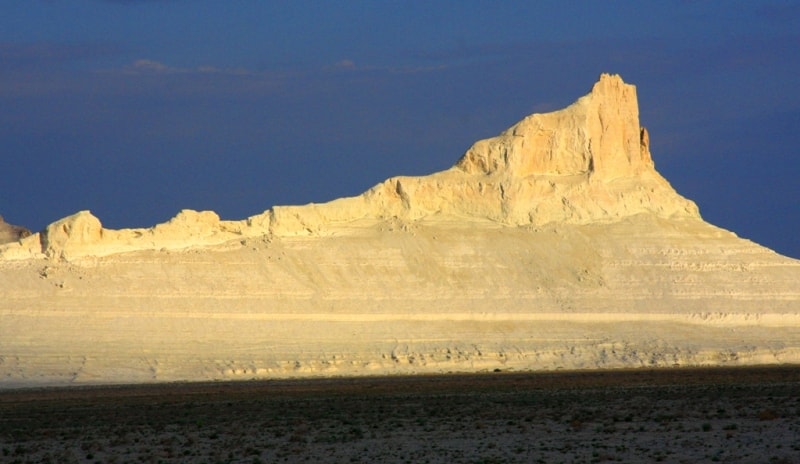
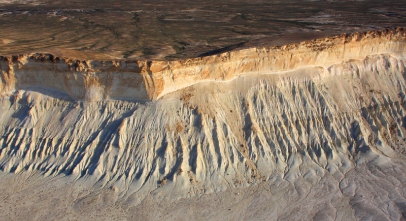
Breakfast. Sunrise – photographing. Walk in vicinities of depression Karynzharyk, descent to bottom of depression, walk on shor Karynzharyk. Photographing. At the bottom of hollow Karynzharyk there is the biggest in Mangistau areas saline land Kenderli in Ustyrt nature national reserve. This place is the most attractive part of a hollow. A highlight saline land Kenderli-sor - five beautiful mountains, towering more than on 100 meters on height in the middle of salty and white silence.
In the most southern part of hollow Karynzharyk there is a mountain with height in 116 meters above sea level named among local population - Tortkul. Three from them cost it is close to each other, therefore local local residents name these mountains «Three batyr» or «Three brothers». The bottom saline land always damp also is covered by a layer of salt which on the sun becomes covered by infinite cracks.
Transfer: Hollow Karynzharyk - settlement of Akkuduk - mount Karashek - rise on the Ustyurt plateau - sixth panorama Ushkir tau of the valley Boszhira (130 km).
We leave one of the most beautiful places of Mangyshlak and road conducts us on the south to new and novel beauty Mangyshlak. On a way the small settlement Ak-Kuduk which has got lost in sand of Mangyshlak is passed, here it is possible to fill up stocks of water. Lunch in way.
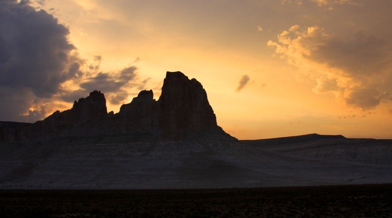
In the environs of saline land Karashek rise on a northeast slope on the Western cliff of Ustyurt. Arrival on the Sixth panorama Ushkir tau of the valley of Boszhira. Walks in vicinities, photographing of a decline, dinner and overnight in tents.
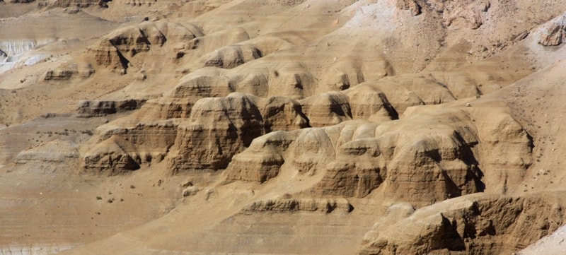
Day 3. Boszhira valley (71 km).
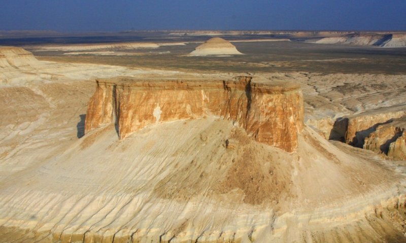
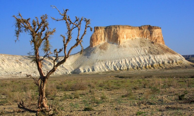
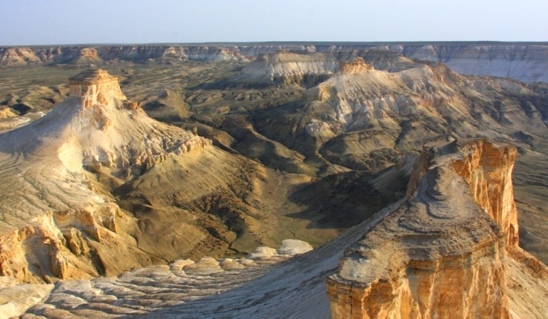
Breakfast. Visit of the Sixth, Fifth, Fourth, Third, Second and First panoramas of Boszhira (25 km). We transfer by car along breaks of the Western chink of Ustyurt with which we observe and we photograph Boszhiraa panoramas. Boszhira valley is in the western part of the Ustyurt plateau on the peninsula of Mangyshlak of Mangystau province. The valley is located near hollow Karashek. Boszhira valley, is an island mountain ridge on the suburb of the Western cliff of Ustyurt.
Boszhira valley is at the bottom of the greatest canyon. Boszhira the valley sight of Mangyshlk occupies the huge space, this unique. We transfer on Zhusaly descent to the Top plateau of the valley of Boszhira (18 km). Lunch. Walk in the environs of the Top plateau. Walk to the Main canyon of the Top plateau, walk in the neighborhood of the mountain Shoky tau.
Walk on the mountain Ulken keme (1500 m). This mountain on which we shall make walk is called – Ulken Keme. It is a part island mountain has the extended, oval form, on district he was stretched from northwest on a southwest. From western and east party he has breakages in height on 20 meters and in some places of a precipice of breakages much more. Extent Ulken keme from a place of an output on it, from a stone ancient wall, before breakage to Azu tisteri - 200 meters.
In the most southern part Ulken keme the width it does not exceed 20 meters, and in initial, northern part, width - hardly more than 40 meters. These eminences - mountains are separated from the main thing Western precipices Ustyrt and are in depth of a hollow. The hollow saline land Karashek is in 10 kilometers to the south from valley Boszhira.
The way on Ulken keme begins with the western party where the highway comes to an end at cretaceous downturn, which tourists name Harbour on which it is necessary for us to rise on a small cretaceous plateau which Borly tau and Ulken keme is between mountain. Having risen on a plateau, we go on northwest crossing a small canyon, we pass cretaceous mountain on the right which closely adjoins east slopes Ulken keme and gradually we rise to east slopes of mountain, then we pass hiking east slope on cretaceous gullies going on the south.
Tracks it is not visible, but the logical way of movement is visible along east slope and soon we come to a place, whence it is already visible a track which deduces us to an ancient stone wall. This ancient wall, has been combined by hands of people to fence off a steep place escaped precipice from other part of mountain, thus it was original shelter. We pass a gate of a stone wall and we leave on a surface escaped ancient precipice and here we on Ulken keme. In some places surface Ulken keme is cut up by cracks.
It is necessary to be extremely cautious at approach edge of breakage. Many tourists like to be photographed on edge of southern breakage, on a background of Azu tisteri Boszhira. I recommend to lay down in the beginning on a stone surface and then to creep up to the edge of breakage, thus it is possible to secure myself against unpleasant sensations of approach a precipice. Returning to Zhogarly plateu on a way of rise.
Transfer: Top plateau of Boszhira - Oynak Boszhira (27 km). With Oynak Boszhira it is possible to see all main and unique sights of the valley Boszhira: mounts Ulken keme, Borly tau, Azu tisteri, Ushkir tau, Borly tau. Walk in vicinities. Tents camp in Boszhira Harbour. Dinner and overnight.
Day 4. Boszhira valley – mount Bokty (95 km).
Breakfast. At sunrise photographing of island mountains Azu tisteri, Borly tau, Ushkir tau, Ulken keme. After lunch transfer: First panorama of Boszhira - Beket-ata mosque (21 km). Before turn on northeast on the right there is a well-known valley Boszhira. Soon the road turns on the north and results us in valley Oglandy.
After visiting mausoleum Oglandy-aта descent on steps, to underground mosque Beket-ata. The distance from descent with cliff up to underground mosque makes, approximately, 1 kilometer of 200 meters, on time it - from 25 till 30 minutes. Difference on height from edge cliff Ustyurt (breakage) up to mosque Beket-ata about 50 meters.
Visiting of mosque Beket-ata. Walk to the most ancient and known necropolis in the Western Kazakhstan which is below mosque in 300 meters. Under legends, Beket-ata veins in two cretaceous rooms which have been cut down in a stone slope.
A fine ornament of a trip to underground mosque Beket-ata can be meetings with Corsican moufflon (Ovis ammon) which have chosen valley Oglandy, here they live and are made multiple copies under protection sacred Beket-ata. Returning on steps to top mosque Beket-ata (45 minutes - 1 hour). Visiting of top mosque Beket-ata.
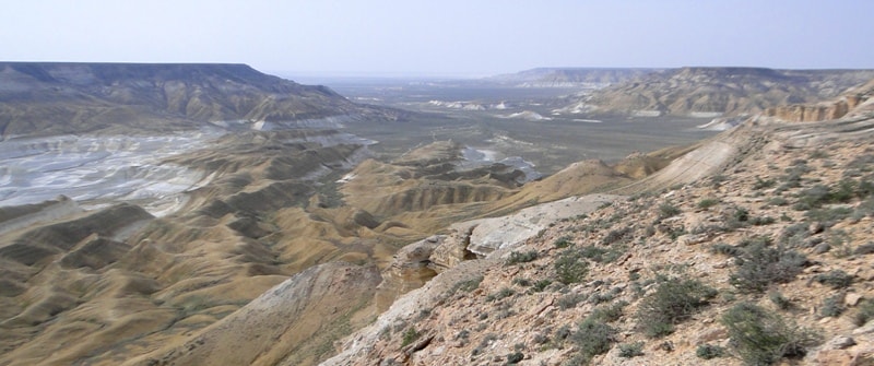
Transfer: Beket-ata mosque - Zhusaly descent - Baysary valley (36 km). Return from Beket-ata mosque on the grader to Zhusaly descent. We pass Boszhira valley and our way to Baysary valley. Baysary valley on Mangystau is, approximately, on the middle of a way between the mountain Bokty and Boszhira valley. After we pass Zhamanauliye litter, rise on cliff with which on the South begins the view of Kamysty valley opens.
Kamysty valley quite extensive area which is in the lowland in the western part of this area cretaceous columns of the valley of Baysary settle down. Baysary are put by absolutely white breeds. In a sunny weather it is impossible to watch shine of a slope which is cut through by columns. Everywhere only chalk is visible. Walks in the environs of Baysary valley.
Transfer: Baysary valley - mount Bokty (13 km). Arrival to Bokty mount, walks in vicinities. Photographing of a decline. Dinner and overnight.
Day 5. Mount Bokty – saline land Tuzbair (145 km).
Breakfast. Transfer: mount Bokty - mosque and necropolis Shopan-ata (46 km). Arrival on the mosque and necropolis Shopan-ata. Walk to the underground mosque and necropolis Shopan-ata. Ritual walk by the top part of the underground mosque.
Transfer: Shlopan-ata mosque - mausoleum Kuy-tam XIIIth century (2 km). Our way lies on the North from where Mangyshlak Muslim shrines begin, the mausoleum to Kuy-tam opens a way for pilgrims to the most significant mosques of Mangyshlak. Soon to the right of the road the platform for parkings of cars, is the mausoleum to Kuy-am, visit of the mausoleum, photography here.
Transfer: mausoleum Kuy-tam – saline land Tuzbair (68 km). Our way lies on the northwest. In the West sands Bostankum in the east sands Tyshkaykum.
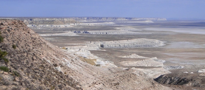
Further transfer on saline land Tuzbair along the Western cliff of Ustyurt (29 km). Here we will on Tuzbair saline land see mount Tortkol 285 meters above sea level, the mount Tuzbair of 272 meters above sea level. Lunch on the way. Walks in the environs of the well-known Arch Tuzbair, the mount Tuzbair 272 meters above sea level. Dinner and overnight.
Day 6. Saline land Tuzbair - town Beyneu (254 km).
Breakfast. Transfer: saline land Tuzbair - Pass Manata (13 km). A stop in the environs of the pass, photographing of landscape panoramas and the mausoleum of Manata.
Further transfer: Pass Manata - mosque Korkembay (191 km). Visit of the mosque, walk in vicinities.
Further transfer: mosque Korkembay - mosque and necropolis Old Beyneu (29 km). The underground mosque Old Beineu is in a southeast from regional center Beineu, in 21 kilometer, to the right of a motorway of the to in Aktau.
Entrance to a mosque Old Baineu is symbolized with a brick, beautiful arch and kilometer avenue of trees which leads to an extensive complex of ancient burial places - Old Beineu. South to the west from a spring and dwelling of shepherds there is the extensive necropolis divided channel of two ravines on two half.
Transfer: mosque Old Beyneu - town Beyneu (21 km). Arrival in Beyneu, transfer to the hotel, accommodation. Evening walk by the central part of town Beyneu. Dinner and overnight.
Day 7. Beyneu - Kungrad (409 km).
Breakfast. Early departure from Beyneu. Transfer: Beyneu - Tazhen check point (82 km). Ggoing through formalities of the customs and border service of Kazakhstan.
Transfer: Tazhen check point - Karakalpakstan check point (21 km), going through formalities of the customs and border service of Uzbekistan.
Transfer: Karakalpakstan check point - settlement of Zhaslyk - town of Kungrad (306 km).
Note:
Author program of Alexander Petrov. Copying and introduction - from the sanction of the author.
Alexander Petrov
photos by: