


![]()
You are here
Tour to mountains of Almaty region.
Tours in mountains of Kazakhstan.
"… We are all carried away into the distance on the same planet - we are the crew of the same ship"
Antoine de Saint-Exupery.
Short description of route of tour across of Almaty mountains:
Distance of route: 1041 km.
Season: from July 10 to September 1.
Duration of tour: 9 days, 8 nights.
Best time for tour: July, August
Distance in an active part of a tour: 5 km.
Detailed program of tour day after day on Shalkudysu and Taban-Karagai valleys:
Tourist routes of Almaty region.
Day 1. Almaty - Shalkudysu valley (353 km).
Transfer: Almaty - Kuldzhinsky tract - Guldala village - Panfilovo village - Baiterek village - Baidibek bi village - Karaturyk village - Shelek village - Baiseit village (140 km). The way from Almaty to the village of Baiseit along the Kuldzhinskaya highway is a little longer than along the "betonka", but much more interesting and informative, the villages stretch in a continuous series one after the other.
In the village of Baiseit, a stop, a visit to the local bazaar, which is located on both sides of the main street of the village, here they sell any vegetables and fruits, hot cakes with onions, pies and much more, there are many different cafes where you can eat inexpensively.
Further transfer: Baiseit - Nura village (10 km). At the end of the eastern part of the village of Nura, 70 meters from the road, there is the Berkutchi museum "Zhety Kazana" and a small farm of the Isabekov family. More than 10 golden eagles, "tazy" dogs are supported by the family.
The owner of a large farm and a museum is Dinara Isabekova. This is the only berkutchi museum in Kazakhstan. The Isabekov family offers small services for visitors and tourists, for a small fee, you can take a picture with a golden eagle, look in the enclosures of hunting dogs - tazy, visit a museum, see a demonstration hunt with a golden eagle in the vicinity of the village.
Transfer: Nura - Kokpek village - Sharyn river - Chundzha village - hot Chundzhinsky springs - Ketpen village - Ketmen mountains - Ketmen pass (203 km). The distance from the village of Ketpen to the Ketmen pass is 20 kilometers.
The Ketmen pass with a height of 3,045.6 meters above sea level is located in the central part of the Ketmen ridge, which stretches from west to east for 240 kilometers, of which 120 kilometers of mountainous terrain are in Kazakhstan, the rest of the mountains are located in the Republic of China.
In the main ridge, the dominant height is the Heavenly Peak with a height of 3652.8 meters above sea level, in the southern branch of the Ketmen ridge in the Karatau Mountains an unnamed peak rises with a height of 3728.1 meters above sea level.
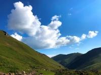
The ascent to the pass is picturesque; as you ascend, the altitudinal zonality changes, which is represented by flora from hot steppes to alpine meadows. From the pass you can see a view to the north, to the valley of the Ili river, in the south you can see the mountains of the Central Tien-Shan with the Sarydzhaz and Meridional ridges.
Transfer: Ketmen Pass - Ketmen gorge - Shalkudysu river valley (12 km). Stop for the night on the foothill hills of the left (eastern part) of the Ketmen gorge overlooking the Shaldkudysu valley, dinner, overnight in tents.
Day 2. Shalkudysu valley - Tuzkol lake (45 km).
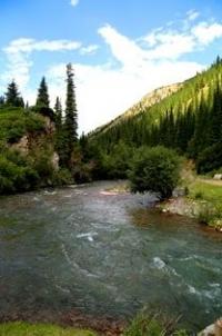
Breakfast. Transfer: Shalkudysu river and valley - Tuzkol village - Tuzkol lake (45 km). The valley of the Shalkudysu, translated from Kazakh as "a beautiful place", is located at an altitude of 1908 meters to 2650 meters above sea level, located between the Ketmen ridge in the north and the Karatau mountains in the south.
The length of the valley is 55 kilometers, its direction is from northeast to southwest, the western end of the valley is located south of the village of Karasaz, the valley begins in the eastern spurs of the Ketmen ridge at the confluence of the Shalkudysu River with the Aygatas River.
The greatest width of the valley in the vicinity of the villages of Karsaz is up to 15 kilometers. On our way to Lake Tuzkol, we will meet a large number of campsites for shepherds and shepherds, where yurts are installed, sometimes there are real yurt auls in which up to 10 yurts are installed.
We will observe a huge number of grazing horses, sheep, cattle in the river valley and on the slopes of the Karatau and Ketmen mountains. If you wish, you can visit the yurts of the shepherds to get acquainted with the nomadic life of the Kazakhs.
Arrival at Tuzkol lake, setting up tents. From the dominant hills that rise in the northern part of the lake, magical panoramas open up to Lake Tuzkol, which encircles the hills from the north-east, east and south. And here we have the mountains of the Central Tien-Shan, which are located on the territory of Kazakhstan, the Republic of China and Kyrgyzstan.
In the south, an endless panorama of the Sarydzhaz ridge opens up, which stretches from east to west in an advanced chain of snow-capped mountains with glaciers and peaked peaks. In the central part of the panorama, the mountains of the Central Tien-Shan rise - the Meridional ridge with the highest peak Khan Tengri, 6995.2 meters above sea level, to the west and south, the highest peak of the Kokshlal Too ridge - Pobeda Peak, 7439.3 meters above sea level.
At sunset hours, if we are lucky and the mountains are open, we will see a magnificent picture of our journey. Dinner. Walking around the environs, dinner, overnight in tents.
Day 3. Tuzkol lake - Buzunbai gorge (84 km).
Breakfast. Transfer: lake Tuzkol - mountains Zhabyrtau (11 km). From Lake Tuzkol, we move along the southeastern edge of the Elshyn-Buiryk mountains and then go around the lake from the southwestern side and, bypassing the Togyzbulak valley, head south to the Zhabyrtau mountains.
The clayey hills of the Zhabyrtau mountains stretch from the southwest to the northeast and are 10 kilometers, the largest width in the central part of the ridge is about 4 kilometers. The highest unnamed point of the mountain range, which is located in the eastern part of 2292.4 meters above sea level.
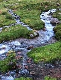
The mountains are cut by dry stream beds, which are filled with water depending on precipitation, spring and autumn floods. The vegetation on the uplands is represented by xerophytes, and the barnyard saline, or biyurgun (Anabasis salsa) is found.
Most of the soil is represented by light clays interspersed with slightly brownish shades, which, in combination with low overhanging clouds, makes the mountains very picturesque.
Transfer: Zhabyrtau mountains - Zhabyr mountains - Zhanatekes village - Tekes village (17 km). The village of Tekes was founded in 1912, the former name is Krasnoyarsk, at present more than 7000 people live in the village.
Transfer: Tekes village - Kyzylush mountains - Karatogan village - Ulken-Kokpak valley - Ulken-Kokpak gorge and river - tourist base - Buzunbai gorge (56 km). After the village of Tekes, we pass the Kyzylush mountains and our path lies along a new asphalt road to the village of Karatogan.
From the village, through low grassy hills, we descend to the valley of the Ulken-Kokpak gorge. The river starts from the Kokpak pass, 3482 meters above sea level on the northern slope of the Terskey Alatau ridge.
At an altitude of 1835.8 meters above sea level, the river between the villages of Tegistyk and Kakpak is dismantled for irrigation of agricultural land in the summer months. Only in the spring months and the flood season does the river reach the Tekes River.
The length of the Ulken-Kokpak River is 50 kilometers. A motor road with several bridges is laid along the gorge along the river. The upper part of the river is very picturesque, along the way there are cozy meadows, the river flows in the frame of the Tien-Shan firs, herbs, mixed forest.
On the right side of the Uzun-Kokpak River, at the mouth of the Buzunbai River, there are several cottages of the camp site. In the vicinity of the camp site, we turn left into the Buzunbai gorge. The length of the gorge is 22 kilometers, above Lake Karakol the gorge becomes narrow, and 10 kilometers above the mouth of the river it reaches its greatest width, where the yurts and tents of shepherds and shepherds are concentrated.
The middle and upper parts of the gorge are very picturesque; tourists are attracted here by fabulous and unique places. In the forest zone, the banks of the Buzunbai River are overgrown with the Tien Shan spruce and mountain ash, higher on the left bank there are thickets of juniper.
A road has been laid along the Buzunbai gorge, in the upper part it is within the power of all-terrain vehicles. By car, you can drive just above the last parking lot of the shepherd, whose house is sheathed with profile tin, about 150-200 meters here you can set up tents.
Walking in the environs of the gorge, dinner, overnight in tents.
Day 4. Buzunbai gorge - Tekes river (59 km).
Breakfast. After breakfast, walk to Karakol Lake (2.5 km). The fresh, flowing lake Karakol is located at an altitude of 3102 meters above sea level, located in the upper reaches of the Buzunbai gorge on the northern slope of the Terskey Alatau ridge.
The length of the lake is 1704 meters, the greatest width in the northern part is 456 meters. The perimeter of Lake Karakol is 4538 meters, the area is 737522 square meters. Judging by the talus slope located on the western side of the gorge, just opposite the ancient, natural dam, it can be assumed that a landslide occurred, most likely as a result of an earthquake from this slope.
Walk in the environs. Return to the camp.
Transfer: Buzunbai gorge - Ulken-Kokpak gorge - ford across the Ulken-Kokpak river - Orta-Kokpak gorge - Kurykokpak river - ford across Tekes river - left bank of the Tekes river (eastern slope of Basuly-Tau mountains) (59 km).
In the lower reaches of the Ulken-Kokpak river, we overcome the ford and turn to the west, to a low pass that divides the valley of the Ulken-Kokpak and Orta-Kokpak rivers, descend into the valley of the Orta-Kokpak river.
For about 12 kilometers, we move along the left bank of the Orta-Kokpak river and again ascend the clay pass 2200 meters above sea level and descend into the valley of the Kurykokpak and Oykain rivers. After overcoming the Oykain river, we again ascend the pass with an altitude of more than 2000 meters, for some time we drive along the hill and soon the descent into the valley of the Tekes river begins.
We move to the place of overnight stay on the right bank of the Tekes river, overcome the ford and stop for the night on the eastern side of the Basuly-Tau mountains. Dinner, overnight in tents.
Day 5. Tekes river - Kuluk-Tau mountains (126 km).
Breakfast. Transfer: Tekes river - Tekes river valley - tourist center - Left Tekes river - Fazhayip sarkyramasy waterfall (26 km). From the place of lodging, we move up the left side of the wide valley of the Tekes River, soon the gorge narrows, we pass the cottages of the camp site and we are at the mouth of the Left Tekes.
We cross the ford on the Left Tekes river and ascend from here 1.5 kilometers along the right side of the Left Tekes river. Soon we are at the Fazhayip sarkyramasy waterfall (translated from Kazakh - "Amazing waterfall"). The waterfall is located at an altitude of 2627 meters above sea level.
The entire stream of the river rushes into a narrow river channel behind which it falls vertically, with a crash, from about 7 - 8 meters in height into an 11 meter basin. The western and eastern walls of the basin are semicircular and reach a height of 10 meters, the river goes down in a northeastern direction.
The pool area is 58 square meters. From the right bank, a narrow path leads to the waterfall, which ends with a rocky platform, from where it is good to observe the waterfall.
Transfer: the Khazhayp waterfall - the upper reaches of the Left Tekes gorge (3 km). After walking to the waterfall, we will continue our journey and climb to the upper reaches on the left side of the river. Walking in the environs.
Transfer: the upper reaches of the Left Tekes gorge - the upper reaches of the Tekes river (8 km). We return to the mouth of the Left Tekes, cross the ford of the Tekes river and climb up along the river on the right side.
Just above the ford, on the left side of the river, a geological history of mountain building, composed of granites, is exposed. Walking in the environs. Lunch on the way.
Transfer: Tekes river - Koksay river - Akbeit river - Akbeyit village - Zhana Tasashy village - Tasashy village - Sarykol village - Kainatpatuz salt deposit (55 km). We go down along the left side of the river to the vicinity of the right tributary of the Tastybulak river and ascend to the pass that divides the rivers into the Tekes and Saryzhaz basins.
We go down the right side of the Akbeit river to the Kegen-Narynkol road. Before reaching the Akbeit village, we turn left and move towards the Zhana Tasashy village. We are moving towards the village of Karkara along the intermountain valley, in the north there are the Sholadyr mountains in the south of Basulytau.
Before reaching 4 kilometers to the village of Karkara, we will visit the deposit of natural salt outcrops on the right side of the small stream Kainatpa tuz, which is located at an altitude of 1965 meters above sea level. The field is 308 meters long and 73 meters wide.
Slightly downstream, on the left bank of the stream, there are also salt outlets. Beautiful crystals meet here. Walk in the environs.
Transfer: Kainatpa tuz field - Karkara village - Kegen village (19 km). Shopping in the Kegen village.
Transfer: Kegen village - Kuluk-Tau mountains (15 km).
From the village of Kegen we move along the road to the north-west, before reaching 2.5 kilometers to the Kegen pass, we turn left towards the village of Zhalauly and here in the foothills of Kuluk-Tau we will stop for the night. Dinner, overnight in tents.
Day 6. Kuluk-Tau mountains - Zhenishke river (117 km).
Breakfast. Transfer: Kuluk-Tau mountains - Zhalauly village - Kegen river (18 km). From the place of our overnight stay, we go onto the road that leads to the village of Zhalauly and then move along the right bank of the river. Stop at picturesque ravines by the river. Walking in the environs. On the way visit the mausoleum of Malay Batyr.
Further transfer: Kegen river - Bestyubinskoye reservoir (21 km).
The panoramic views of the reservoir from the right bank are very picturesque, the indented right banks with blue bays and cone-shaped hills add a unique flavor to the perception of nature. The Bestyubinskoye reservoir is a part of the hydroelectric facilities of the Moinak HPP.
Formed by a rock-fill dam 94 meters high, the length of the dam is 515 meters, the width along the crest of the dam is 12 meters, the width of the dam along the bottom is 310 meters. The length of the reservoir is 4.5 kilometers (08.2021), the largest width in the central part of the reservoir is 386 meters.
The maximum depth is 80 meters. Walk in the environs. Lunch on the way.
Transfer: Bestyubinskoye reservoir - Kensu village - Orta-Merke river - Shet-Merke river - Toguzbylak village - Zhalanash village - Zhanatalap village - Algabas village - Zhenishke river (78 km).
We will end today in a cozy meadow on the left bank of the Zhenishke River. Here you can admire the thickets of barberry, tall poplars, observe and take pictures of interesting nests of the penduline bird. Walks in the environs, dinner, evening fire, overnight in tents.
Day 7. Zhenishke river - Taban-Karagai valley (62 km).
Breakfast. Transfer: Zhinishke river - Biesuymes gorge - Taban-Karagai forestry - ranger post - Tuyme river - Taldybulak river - tourist base - Kairakty gorge (53 km). After spending the night on the left bank of the Zhinishke river, we move along the road towards the village of Zhinishke, cross the bridge, turn left and climb along the right side of the Biesuimes gorge.
Our path lies along a vast watershed upland between the valleys of the Zhinishke rivers in the north and Shilik in the south. Then we pass a small pass 2476.2 meters above sea level and go down to the Taban-Karagai forestry, which is located on the right bank of the Zhinishke River.
The Taban-Karagai valley is located in the eastern part of the Zailiyskiy Alatau ridge at the junction with the western end of the Sarytau ridge. The valley is located on the northern slope of the Zhenishke gorge, it stretches for 15 kilometers from west to east.
A tourist base of 4 cottages is located 18 kilometers west of the huntsman post. The valley is very picturesque, on the northern slope there are Tian-Shan spruce, mountain ash, willow, abundant herbs. We will pass the jaeger post and continue along the road that runs along the northern slope of the Zhinishke River.
On the way, to the south of the road, there are several cottages of the tourist center. We pass the fords through the Tuyme and Taldybulak rivers. The end of the road at the western slope of the Kairakty gorge. Walk in the environs.
Return to the Tuyme and Taldubulak interfluve (9 km), dinner, overnight in tents.
Day 8. Taban-Karagai valley - Asy plateau (86 km).
Breakfast. Transfer: the Taldybulak river - the watershed plateau between the Zhinishke and Shilik rivers - the Biesuimes gorge - the Zhinishke river - the Zhinishke village - the mouth of the Kindyksay river (41 km). We return to the Zhinishke river, passing the watershed plateau between the Zhinishke and Shilik rivers and the Biesuymes gorge, passing through the village of Zhinishke and just above the village at the mouth of the Kindyksai river, stop for lunch.
This is a very picturesque place, on the right bank of the Zhinishke River there are red outliers, which were formed in the process of weathering. We will have a picnic in the clearing of the left bank.
After lunch, transfer: the mouth of the Kindyksai - the Zhambas river - the river - Kyzylauz - the Sulysay river - the Kyzylauz pass (24 km).
From the Zhinishke River we ascend to the northwest along the southern slope to the ridge of the Sarytau ridge. After a ford across the Sulysay River at an altitude of 2566.7 meters above sea level, the road becomes much worse.
From here, steep serpentines with large and small and numerous stones begin, a track washed out by rains. Soon we are at the Kyzylauz pass 3077 meters above sea level. A magnificent view of the valley of the Zhinishke river, the Taban-Karagai valley opens from the pass.
From here you can clearly see the jaeger post in the Taban-Karagai valley, the road. The Kungey Alatau mountain range with snow-capped peaks and glaciers of northern exposure stretches in front of us, stretching from south-west to east. In the north of the mountain is the Zailiyskiy Alatau.
Transfer: Kyzylauz pass - Karaarsha river - Koktobe mountains - Asy river - Asy pass - Asy-Turgen observatory (21 km). We descend from the pass to the north-west to the Karaarsha river, wade it to the left side, pass the Koktobe mountains, at an altitude of 2357.8 meters above sea level, move to the left side of the Asy river.
From here we ascend to the Asy pass 2510 meters above sea level, from which a grader was laid to the Asy observatory. Walking in the environs, dinner, overnight in tents on environs Asu-Turgen observatory.
Day 9. Observatory Asy-Turgen - Almaty (109 km).
Breakfast. Transfer: Asy-Turgen observatory - Kiishi-Turgen river - Turgen river - Turgen gorge - Turgen village - Issyk village - Baiterek village - Panfilovo village - Almaty.
Arrival in Almaty, end of the tour.
Note:
Author program of Alexander Petrov. Copying and introduction - from the sanction of the author.
Photos by
Alexander Petrov