


![]()
You are here
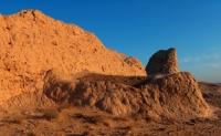
Tok Kala ancient settlement.
Weekend tours in Karakalpakstan.
"The lousiest donkey laden with gold can open any gate."
Eastern proverb.
Sacred places in Karakalpakstan.
The Tok Kala settlement is located on a small natural hill Toktau 87.7 meters above sea level, 8.7 kilometers northeast of the right (eastern) bank of the Amu Darya River, 15 kilometers northwest of the city of Nukus, 7, 6 kilometers south-east of the village of Krantau, 2.5 kilometers south-west of the village of Akmangit, in the Nukus region of the Republic of Karakalpakstan.
Tok-kala (Darsan) consists of 3 parts - antique, early medieval and burial ground. The most recent study of the monument was carried out in 1998 during the educational field archaeological practice of the Department of History of the Azhiniyaz State Pedagogical Institute.
The topography of the settlement was examined, in the early medieval part, small studies were carried out, excavations were carried out in the size of 3 x 6 meters of the room where the burial of a person was opened, bones were found inside a small ceramic molded vessel of the jumcha type.
It was covered with a brick of antique look, possibly taken from the ancient wall of the settlement. Tok - kala, archaeological complex. Toktau hill on which the settlement is located - "Bulk Mountain", it is associated with the legend about the artificial hill, poured by the Virgin, on which the fortress was built.
Recent archaeological data show that Tok is a settlement of the late Afrigid period. "Tok" was given later by the inhabitants of the Karakalpaks (in the Darsan sources)
Geographic coordinates of the Tok Kala ancient settlement (Darsan): N42 ° 34'54.36 "E59 ° 30'54.90"
Authority:
A.V. Gudkov. "Fecal flow". Karakalpak branch of the Academy of Sciences of the Uzbek SSR. Institute of History, Language and Literature. Tashkent, 1961.
Photos by
Alexander Petrov.