


![]()
You are here
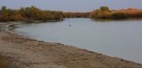
Tedjen River.
Guided day hiking in Turkmenabad.
"Water is the softest and weakest creature in the world, but in overcoming the hard and strong it is invincible, and there is no equal in the world."
Lao Tzu.
Mountain Trails in Ashgabad.
The Tedjen River flows through the territories of Iran, Afghanistan and Turkmenistan. The total length of the river is 1150 kilometers, the basin area is 70 600 square kilometers, the average flow rate is 31 cubic meters per second.
The source of Tedjen is located in central Afghanistan at an altitude of about 3000 meters above sea level, on the southern spurs of the Ghisar ridge. The river originates at the confluence of the Shorkul and Siahnashma rivers.
Before the Afghan city of Herat, it is a mountain river flowing through a narrow valley to the west of the country. Near Herat, the valley becomes wide and the river becomes flat. After the Herat oasis, Gerirud again takes on a mountainous character and serves as a natural border between Afghanistan and Iran.
Then the valley expands again and forms the border of Iran with Turkmenistan. Before the city of Herat, Tejen is a mountain river that flows through a narrow valley, forming rapids and waterfalls. Passing the Herat valley, the river turns sharply to the north, cutting through the Safedkokh ridge, enters the borders of Turkmenistan, where it flows for about 300 kilometers.
The river valley, reaching a width of 2 kilometers in places, is bounded by steep loess banks. In some places the valley is covered with dense shrubs. In summer, in connection with the analysis of water for irrigation, the Tedjen channel below the village of Pulikhatum dries up and only in some places, due to the replenishment of irrigation return water, water is constantly stored.
Above the village of Serakhs, the river receives several tributaries, of which usually only the Keshe-Frud carries its waters to the main river. The Tedjen Delta is a sandy-argillaceous plain dissected by many channels.
Part of the delta area is occupied by cultivated vegetation, in some places there are wetlands overgrown with reeds and reeds. The waters of Tedjen are almost completely understood in the Herat and Tedjen oases.
It has a so-called blind delta, that is, the delta fan dissolves in the sands of the Karakum desert. n the lower reaches, it crosses and uses the waters of the Karakum Canal. The food is mainly snow. High water is observed in March, May.
The river, as a rule, dries up in August - November. Tedjen does not freeze. The waters of the river are highly turbid. The Salma reservoir is located in Afghanistan. Near the town of Tedjen in Turkmenistan there are the Khorhor and Tedjen reservoirs with a capacity of 0.142 cubic kilometers and 0.18 cubic kilometers.
In 2004, a dam of the Iran-Turkmen Friendship was built on the river near the border with Iran, the resulting reservoir has a volume of 0.82 cubic kilometers. Both countries use its water. Electric generators with a capacity of 16 MW are installed at the dam.
Authority:
http://www.cawater-info.net/bk/water_land_resources_use/docs/rivers.html
Photos by
Alexander Petrov.