


![]()
You are here
Tarbagatai mountains.
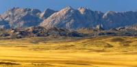
Trip to mountains of Tarbagatai.
"In the open space, in the open
Near the Tarbagatai Mountains
And the spurs of the Alatau,
From the turbulent waters of Balkhash
Floor of the steppes to Alakul
In the old, bygone years,
Which have reached us only in songs,
In ancient tales and legends,
Inseparably roamed
Two rich noble bays."
"The Tale of Kozy Korpesh and Bayan Suu." Georgy Tveritin.
Sights of Tarbagatai Range.
Tarbagatai ridge sharply rises above Zaysan intermountain hollow separating Saur-Tarbagatai system from Altai and is characterized by spread of desert and semi-desert landscapes. Lake 3aysan, flowing, fresh, shallow, belongs to upper Irtysh.
The Black Irtysh flows into it, and the Irtysh begins from it. The water backwater caused by the construction of the Bukhtarma Hydroelectric Power Station on the Irtysh River led to the connection of the lake with its reservoir and captured the lake itself, flooding, in particular, the swampy delta of the Black Irtysh, which made the lake much larger (length from 100 kilometers increased to 150 kilometers).
Significant are its fish wealth.
The Tarbagatay ridge is located in the west of Saura and connects with the Chingiztau ridge (250 km). It is lower, but longer than Saura, 300 kilometers, its width is 30-50 kilometers. Relief and geological structure, minerals. On the territory of Kazakhstan is the western part of Tarbagatai (from the Khabar Asu pass to the Ayaguz river), as well as the northern slope of its eastern part.
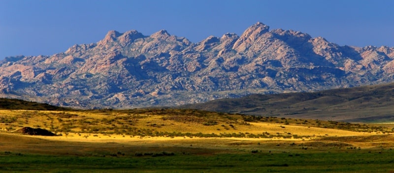
The southern slope of the eastern half of Asu remains on the Chinese side. Tarbagatai ridge is not very high. Its average height a2000 is 2200 m. a. s. l. The highest point - Tastau reaches 2992 m. a. s. l. The structure of Tarbagatai is composed of folded blocks.
he tops of the mountains are very flattened. They are characterized by aligned flat sections. The slopes of the mountains are weakly dissected by gorges. There are no glaciers. Tarbagatai is mainly composed of Paleozoic rocks (clay and crystalline schists, sandstone, limestone and conglomerate).
In the Tarbagatai ridge, limestone, often many granites that are absent on Saur, are often found. Tarbagatai Range is a folded mountainous country. Its tectonic structure is formed in the Late Paleozoic during the passage of the Hercynian folding. During alpine mountain-building, Tarbagatai was renewed.
The formation of the modern relief was influenced by ancient glaciations, erosive effects of flowing waters and new tectonic processes. So, in 1990 there was a strong earthquake in Zaysan, which caused significant material damage.
The rivers Urjar, Khatinsu, Emel, flowing down from the southern slope of Tarbagatai, flow into Lake Alakol, the Ayaguz River into Balkhash.
The ridges are composed of strongly dislocated Paleozoic sedimentary rocks (schists, limestones, sandstones), broken by acidic intrusions (granites, etc.). The Tarbagatai ridge is lower (up to 2992 meters above sea level), but it is much longer.
The western Tarbagatai consists of two anticlinorias approaching the east, and the southern reaches greater heights than the northern. The East Tarbagatai Range has massive block elevations. The Tarbagatai Range has a Hercynian folded structure. In the post Hercynian period denudation processes took place here.
In the Mesozoic and Paleogene, the territory had a continental platform mode with small amplitudes of vibrational movements. The relief, apparently, resembled the modern surface of the Kazakh small hills. The ridges have reached their present height and as a result of powerful uplifts occurring in the Neogene and the beginning of the Quaternary.
The ridge is composed of strongly dislocated Paleozoic sedimentary rocks (schists, limestones, sandstones), broken by acidic intrusions (granites, etc.). The slopes of the ridges are deeply divided by gorgeous valleys. At Tarbagatai, the northern slope is more south, the ridge is flattened; the watershed is pressed against the steep southern slope of the ridge; in Paleozoic limestones on the ridge, karst phenomena are developed.
The lower parts of the slopes of both ridges are occupied by semi-desert and higher steppe vegetation. Siberian fir is found in the form of admixtures in spruce forests. In the river valleys, forests rise to an altitude of about 2600 meters above sea level.
In Tarbagatai, woody vegetation is found only in river valleys, and for the valley of the southern slope thickets of wild apple trees are characteristic. Outside the valleys on the southern slope, shrubs from rose hips, honeysuckle, meadowsweet, etc. are widely developed; on the northern slope, sod-grass steppes are widespread.
The upper mountain zones of both ranges have mountain meadow (subalpine and alpine) and loach landscapes. The meadows contain Altai and North Kazakhstan plant species. Like the Dzhungarsky Alatau, the Tarbagatai ridge, by nature, occupies an intermediate position between the mountains of South Siberia and Central Asia, but their nature is even closer to Siberian, as evidenced, for example, by the spread of Siberian larch on the Tarbagatai ridge.
The flora and fauna of the mountain system Tarbagatai is divided into mountain-steppe territory. In the Tarbagatai steppe shrubbery vegetation predominates. On the northern slopes of the mountains, the landscape consists of plants of alpine meadows, on the southern of shrubbery plants.
Sievers apple trees, aspen, and silver poplar grow in ravines. Tarbagatai high meadows came from Altai, and species such as an apple tree and Turkestan juniper from the Tien Shan. The low-lying steppes of the southern slopes are used as pastures: many species of wormwood grow there.
In the vicinity of the mountains sowing land and grazing land are located. The western slopes of the mountains are occupied by orchards and vineyards. Forests consist of Siberian gray spruce and Tien Shan spruce. In Tarbagatai, woody vegetation is found only in river valleys, and thickets of wild apple trees are characteristic of the valley of the southern slope.
Outside the valleys on the southern slope, shrubs from rose hips, honeysuckle, meadowsweet, etc. are widely developed; on the northern slope, sod-grass steppes are widespread. The upper mountain zones of both ranges have mountain meadow (subalpine and alpine) and loach landscapes.
The meadows contain Altai and North Kazakhstan plant species. This once again proves that the territory between Siberia and Central Asia is a transitional place. The semi-desert steppe of Shilikty occupies the gap between the south of Saur and the eastern part of Tarbagatai.
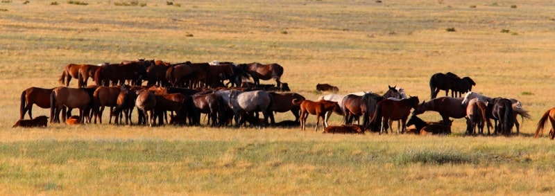
The soil is solonchak-gray and stony, stone grass, wormwood, and fescue grow. The fauna of Tarbagata is diverse. Brown bears, deer, roe deer, mountain goats, arkhara, wolves, foxes and others live here. Mountain, steppe and semi-desert species of animals are found.
In these regions, from the animals live a striated strident scallop (snake), white-headed crane, bustard, saj, Ular, golden eagle, peregrine falcon, saker falcon, eagle owl, listed in the Red Book of Kazakhstan.


Authority:
N.A. Gvozdetsky, N.I. Mikhailov. “Physical geography of the USSR. Asian part. Third edition, amended and supplemented. Moscow “Thought” 1978. http://tapemark.narod.ru/geograf/1_5_5.html
Photos by:
Alexander Petrov.