


![]()
You are here
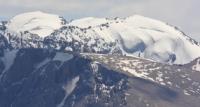
Takali mountain range.

Mountains of Tajikistan.
“By the fifties of the last (XIX) century, the entire amount of European information about the Heavenly Ridge of the Chinese was given by Ritter Asia, and clearly - the maps of d'Anville in the later processing of Klaproth. This knowledge, if not equal to zero, was insignificant."
G.E. Grumm-Grzhimailo.
Pamir-Alai adventures.
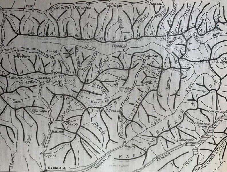
The area of the junction of the Gissar ridge with the Zeravshan in the middle part of the Pamir-Alai between the Fan Mountains in the south-west and the Matcha mountain knot in the north-east is usually called the Takali mountain range, located in the Sughd region of Tajikistan.
The northern part of the massif is a section of the Zeravshan ridge, which is elongated in the latitudinal direction; its length from the junction with the Gissar ridge to the mouth of the Yagnob, which flows into the Fandarya, is about 130 kilometers.
The northern and southern slopes are steep, cut by deep, narrow gorges and canyons. The Gissar ridge, the length of which within the Yagnob basin is 155 kilometers, departing from the Zeravshan ridge at the Takali peak with a height of 4450 meters above sea level, bends to the south at the sources of the Barzangi, Sangdara rivers, then in the area of the Khoki pass it takes the general western direction.
At the beginning of the Gissar ridge, first to the east, then to the south and then to the southwest, the Karategin ridge departs.
To the west of its beginning, the Ramit spur branches off in the southern direction from the Gissar ridge. In the west, closer to the Anzob pass, a large branched spur leaves the Gissar ridge to the south, forming the Sangi-Navashi knot, and to the north - a short spur with an interesting ending with significant glaciation - Zamin-Karor (Yagnob wall).
The highest point of the region - a peak with a height of 5145 meters above sea level, a pyramidal peak - is located in the Zeravshan ridge, in the upper reaches of the Yagnob River. The greatest glaciation in this area is developed on the northern slopes, where glaciers of the valley type prevail.
The southern slopes are dominated by tar glaciers. Climatic conditions, flora and fauna are not much different from the Fann Mountains. The nature of the paths along the rivers is heterogeneous: they are well developed, then, on the contrary, they become difficult to pass, often disappear.
In the recent past, the area was more inhabited, as evidenced by the ruins of numerous villages. There is no permanent population in the upper reaches of the Yagnob. A number of small villages are located along the Zeravshan River.
In the valley of the Sardai-Miena River, above the village of Pechev, there are no residential villages. The uppermost village of Sorbog is located in the valley of the Sorbo River. On the watershed of the Sardai-Miena and Sorbo rivers, in the lower part of the Romit spur, there is the state reserve "Romit".
Takali junction from the north can be reached by car from Aini, along the valley of the Zeravshan River. In the west, there is a road from Dushanbe to Aini through the Anzob pass. The fastest approach from the south and east is along the Pamir highway.
Buses run regularly from Dushanbe and Ordzhonikidzeabad to Ramit. The upper reaches of the Sardai-Miena and Sorbo rivers can be reached by car. In general, the Takali region is not well studied in terms of tourism.
Its active development by tourists began only in recent years; tourist schemes are not always accurate. This list contains far from all the passed passes, their nature and categories of difficulty require clarification.
There are many "white spots" left in the region, opportunities for exploring and passing new passes.
Geographic coordinates of the Takali mountain range: N39 ° 13'21.87 "E67 ° 59'18.14"
Authority:
V. I. Ratsek, "Five Highest Peaks of the USSR", Publishing House "Uzbekistan", Tashkent, 1975.
Photos by
Alexander Petrov.