


![]()
You are here
Shalkarteniz depression and salt marsh.
Sights of Irgiz-Turgai reserve.
“I would like to stand here and watch everything
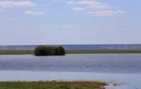
View of the lake from the side.
The shores breathe silence,
There are no lights and no people here,
Through the thickets of only reeds
The swans' necks turn white."
Saken Seifullin. (1894 – 1939). "Separated Swans".
Lakes of Shalkarteniz depression.
Depression and salt marsh Shalkarteniz is located at an altitude of 50 meters below sea level, located in the depression of same name, south of remnant ridge of Shalkarnur, north of small ridge sands: Zhamankum, Baydakashka and Bayukutkum, on territory of southern regional branch of state natural reserve "Irgiz-Turgaisky", in Irgiz district in eastern part of the Aktobe region.
Shalkarteniz (Chelkartengiz, Chelkar-Tengiz; Kazakh Shalkarteniz - boundless sea) is a salt marsh, partially swampy depression in the lower reaches of the Turgai River. The Shalkarteniz salt marsh belongs to the Turgai-Central Kazakhstan region, the Lower Turgai province, the Western Turgai district, the Irgiz-Ulkayak and Turgai regions.
The salt marsh includes wetlands of international importance, the mouth of the Torgay River, the Shalkarteniz flat depression, lakes Kurdym, Karakol and Bakshakol, located in the lower reaches of the Torgay River. Shalkarteniz lies in a depression with low, gentle, mostly sandy slopes.
In spring, it fills with water, turning into a bitter-salty lake with depths of 2 - 3 meters. The territory of the Shalkarteniz salt marsh is included in the list of the International Union for Conservation of Nature (IUCN) as wetlands of international importance for the conservation of unique aquatic and semi-aquatic bird species.
The lower reaches of Torgai and Irgiz lie within the Aral-Ishim section - one of the powerful migratory flows of waterfowl. During migration, at least 2 - 3,000,000 migratory birds (250 species, including 32 rare and endangered) fly by. On the territory of the Shalkarteniz depression on lakes Karakol and Kurdym, a large number of waterfowl and wetland birds stop for nesting, including species listed in the Red Book: pink and Dalmatian pelicans, spoonbill, ibis, little egret, flamingo, little swan, whooper swan , red-breasted goose, white-headed duck, Siberian crane, gray crane, demoiselle crane, bustard, jack, little bustard, lapwing, slender-billed curlew, black-headed gull, black-bellied and white-bellied sandgrouse, sajah, peregrine falcon, saker falcon, white-tailed and long-tailed eagles, golden eagle, imperial eagle, steppe eagle, snake eagle, osprey.
Reed and bush thickets of shallow areas of reservoirs are the habitat of the wild boar. The Shalkarteniz depression is fed by the waters of the rivers: from the east - Torgai, Shunkai, from the north - Aksai, from the west - Tegene, Zhangylozek.
The territory of the Shalkarteniz depression consists of dry channels deeply cut by riverbeds, ravines, gullies and many drainage basins. The western and southern parts of the Shalkarteniz depression are under the influence of sand massifs.
The sands are secured by semi-shrub and herbaceous vegetation. The length of the Shalkarteniz salt marsh is 62 kilometers, the greatest width in the northern part reaches 54 kilometers, in the southern part 57 kilometers. The length of the coastline of the Shalkar Teniz salt marsh reaches 365 kilometers, the area of the salt marsh is 1464.24 square kilometers.
Until the end of the 16th century, the depression was filled with the waters of the once more abundant Turgai River, which then broke through towards the Aral Sea. After the river shallowed, the reservoir lost contact with the Aral Sea basin. In the south, the depression is surrounded by sandy deserts.
In spring, the waters of the branches of the Turgai River flow into Shalkarteniz, and it turns into a shallow, bitter-salty lake (up to 3 meters deep). On pre-war maps the depression was designated as a single lake. Due to the increase in water intake from the Turgai and Irgiz rivers, Shalkarteniz dried up, turning into rubbish and throughout the 1960s it was a deserted salt marsh in the Aktobe region.
However, the snowy winter of 1969 - 1970 caused an early and unusual heavy floods on the rivers of the Turgai Hollow. High floods occurred again in 1971 and 1972. As a result of the filling of the basin, flamingos returned to the islands of the basin lakes, establishing summer nesting colonies here.
Currently, near the depression there are 8 lakes of varying sizes and salinity fed by the flood waters of the Turgai River, the largest of which are Kurdym, Karakol, Zhyngyldy and Bakshakol. On the territory of the Shalkarteniz depression there are famous paleontological and paleobotanical monuments that require study.
On the northern side of the Shalkarteniz litter in 1912, the remains of a giant mammal - Indricotherium - were found. This animal, 8 meters long and up to 7 meters high, lived in park-like forests that grew on our land 30 - 25,000,000 years ago. The reasons for their extinction are unknown.
The skeleton of Indricotherium, found in the Shalkarteniz depression, is an exhibit of the paleontological museum of the Academy of Sciences in Moscow.
Geographic coordinates of Shalkarteniz depression: N48°11'22 E63°11'19
Authority:
Alexander Petrov.
https://ru.wikipedia.org/wiki/%D0%A8%D0%B0%D0%BB%D0%BA%D0%B0%D1%80%D1%82%D0%B5%D0%BD%D0%B8%D0%B7
Photos by:
Alexander Petrov.