


![]()
You are here
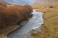
Saty river in “Kolsai Kolderi” park.
Botanical tours in “Kolsai Kolderi” park.
"Life on travel goes on as usual: a certain daily routine is developed, everyone knows their responsibilities, these responsibilities take the whole day - from sunrise to dark"
Academician L. S. Berg.
Observations of fauna in “Kolsai Coldderi” park.
The sources of the Saty River are located at an altitude of 3295 meters above sea level, the mouth is at an altitude of 1429.1 meters above sea level, the river is located on the northern slope of the Kungei Alatau ridge, on the territory of the Kolsai Kolderi natural park in the Kegen district of the Almaty region.
6.7 kilometers after the confluence of the Kolsai, the Chilik River receives a 25-kilometer tributary of the Saty; this is the longest river flowing down from the northern slope of the Kungey Alatau ridge. At an altitude of 2699 meters above sea level, the Saty River, after its source, receives the first, right unnamed tributary, 2.3 kilometers below the second insignificant stream.
There are only two left tributaries on the river. At an altitude of 1590 meters, 2 kilometers in front of the village of Saty, on the river, there is a dam caused by a landslide from the left bank of the gorge. In this place, there is a slight backwater and flooding of the river with the formation of several channels.
There are no glaciers or moraine lakes in the upper reaches of the Saty gorge. In the middle part, the slopes of the gorge are covered with spruce forest. The alpine zone is covered with alpine meadows.
Geographic coordinates of the Saty River: N42 ° 57'36.28 "E78 ° 23'59.02"
Authority and photos by
Alexander Petrov.