


![]()
You are here
Сaravan roads of Kazakhstan.


Tours on the Silk way of Southern Kazakhstan.
"Оn entering the limits of the Tien Shan the wanderer from the Apennines made а stop to have а short rest in Kassae (Hanchjow). There he marvelled not only at the emperor's garden and palaces оn the man-made hilI of Guashan and the Sihu Lake with hundred-year-old turtles and the Un'he - the Great саnаl of 3,564 leas long (1 lеа = 500 metres)"
Tour Historic Monuments of Kazakhstan.
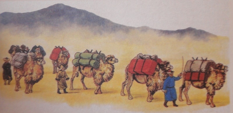
The Great Silk Route is one the most significant achievements in the history of world civilization. The widespread network of caravan ways crossed Europe and Asia from the Mediterranean coast to China, and in ancient times and Middle Ages served as important means of business relations and cultural exchanges between East and West.
The longest part of the Silk Route lay across the territory of Central Asia and Kazakhstan.
Caravan laden with silk from China, spices and precious stones from India, silver goods from Iran, Byzantine cloths, turkic slaves, Afrasibabian ceramics and many other oods, moved through the Kara-Kum and Kyzyl deserts, the boundless steppes of Sary-Arka; passed over theridges of the Pamirs and Tien-Shan, the Altai and the Karatau Mountains.
On the way of the caravans there were settlements and towns - Merv and Bukhara. Samarkand and Urgench, Otrar and Chimkent, Taraz and Balasagun, Sauran and Talgar. But the beginning of the contacts and exchanges goes back to the third-second millennia b.c.
These relations were established due to exploitation of lazurite in the Badakshan Mountains and nephrite - upstream the Yarkend-Darya in the Khotan area. Lazurite, extracted in Badakhshan, was exported to Iran, Mesopotamia, Anatolia. Egypt and Syria. In the middle of the first millenium a.d. lazurite appeared in China. At the same time with the Lazurite Route, which connected Central Asia and the Middle East with the Mediterranean area and India, these existed the Nephrite Route. connecting eastern Turkestan with China.
In the middle of the first millenium b.c. the Steppe Route began to operate: from the Black Sea area to the Don banks, to the land of the Savromats in the south ofpre-LJral region and further - to the Altai, the land of the Agrippies, who inhabited the Upper Irtish and Zaisan lake areas. Export of Chinese silk to other countries, including western countries, began in the fourth - fifth centuries b.c. Export of precious Chinese silk was greatly promoted by nomadic tribes of Saks and Scythians, who provided with these wonderful goods the regions of Central Asia and Mediterranean countries.
At that very time silk was brought to India and the majority of investigators suppose, that the Silk Route at that time only began to originate and develop into the trade highway. It was but in the middle of the second century b.c. that the Silk Route began to function as a regular diplomatic and commercial artery. This started in 138 b.c., when Prince Zhang-Jian, sent on his journey by the Emperor Wu-di, set out from the capital of Han to the unknown western countries, escorted by embassy caravan. Zhang-Jian returned only 13 years later.
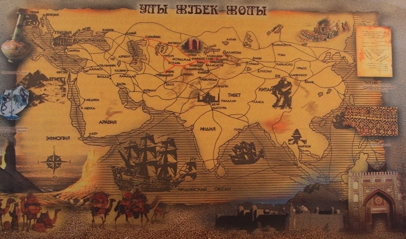
Blazing of the new trails was tightly connected with the process of urbanization. which began first in the southern regions of Central Asia and then spread to central and neigbouring northern and steppe regions. Therefore, it is thougt to be expedient to distinguish three main routes lying across the territory of Central Asia and: southern, central and northern. The southern route started from the town of Amul on the Oksa river and then, dividing into three branches, ran in different directions: first-via Bukhara, Kasan, Kerki, Termez. Baktri; second - via Bukhara, Samarkand, Shakhrisabz, Kerki, over mountain pass Akrobat - to Termez, Baktri; third - through Bukhara, Samarkand. Uzunkir. Daratepe, Budrach, Haitabadtepe, Termez - to Baktri.
The central route lay throug Amul on the river Oksa to Paikend, Bukhara, Samarkand, Dizak. Zaomin, Zamgar, Hadjistan, Turmukhan, Bab, Akhisket. Osh. Uzgend and further over mountain passes to Kashgar. The northern route struck via Amul to Bekhara, Dimas, Tavavis, Karmana. Dabusia. Rabidjian, Zarman, Samarkand, Abarket, Rabad, Saeda, Harkana, Dizak.
Leaving Dizak, it then divided into two branches: from Zaoman to Hawas, Harashkat, across the river Yaksart, to Benaket, Binket; via Hussein and Humeid weiis to Vankend. Undjaket, Chinanchiket and further to Shutukert, where it joined the southern branch and led to Binket, the capital if Shash. In the sixth - seventh centuries a.d. the route, passing through China to the west via Semirechie and southern Kazakhstan, became the busiest one, although that, lying through Fergana, was shorter and more conventent. And in the seventh century a.d. the way via Fergana became dangerous because of internecine dissension.
Thirdly, wealhy Turkic kagans became large-scale consumers of foreign goods. Thus, the route became the major jne and it was there, that important embassy and trade caravans passed in the seventh-fourteenth centuries a.d. In the sixth - eighth centuries the main route was that, leading from Syria, through Iran, Central Asia, southern Kazakhstan, the Talas and Chu valleys, Issyk-Kul area to eastern Turkestan. This route had a branch, connecting Byzantium via Derbent, pre-Caspian steppes, Mangyshlak and the pre-Aral region, with southern Kazakhstan, where it joined the main route.
Later, in the ninth-twelfth centuries a.d., this branch wasn't as widely used as that. However, in the thirteenth-fourteenth centuries the significance of this branch increased again. Very often the state of political affairs on the continent determined the choice of the route not only for envoys and merchants, but also for other travelling people. What did southern Kazakhstan and Semirechie regions represent at the time of their involvement into the Silk Route activity? From time immemorial this area was known for unique culture, which had been created for ages by nomadic and settled tribes.
Interaction and mutual enrichment of nomadic and settled cultures have shown an amazing effect, created by the peoples of Central Asia and Kazakhstan. In the fourth-third centuries b.c. this was the land of nomadic and semi-nomadic tribes of the Saks, whose highly developed culture is known the archaelogical excavations of numerous burial mounds, such as Besshatir, Issyk, Teghisken, Uigarak. In the second century b.c. - the begining of the first millenium a.d. there were ancient states of Kangui andUsun on the territory of Kazakhstan, by that time the Silk Route became a busy highway, promouting penetration of Roman glass and coins, Chinese silk, mirrors and varnishes, European fibulas and various stone-signets from the Sassanian empire.
In the second half of the fourth century a.d. Semirechie and southern Kazakhstan joined the powerful Turkic Kaganat - great nomadic empire, extending from Korea to the Black Sea. By the end of the sixth century it broke up into two parts - eastern Turkic and western Turkic Kaganats. It was at time, that this section of the Silk Route had exerted a great influence on the development of urban and feudal culturesof Semirechie and Southern Kazakhstan, in the Semirechie region there emerged a number of towns, while in southern Kazakhstan it gave growth to those towns, which lay on the Silk Route or maintained commercial relations with it.
Among them the largest were Suyab, Taraz and the town on the White river bank. which was later called Ispidjab. The Great Silk Route, passing through Central Asia, southern Kazakhstan and Semirechie, prospered up to the fourteenth century. Intestine wars and dissensions resulted in gradual decline and destruction of urban culture.
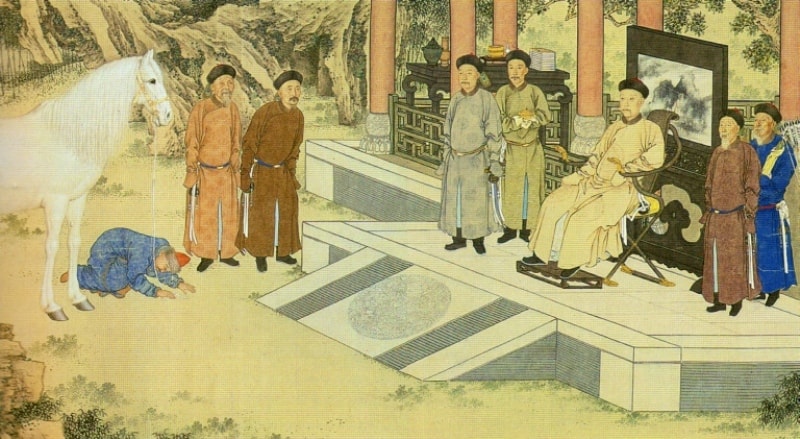
Taraz is one of Kazakhstan's most ancient cities, known since the sixth century a.d. Here, in 568 a.d., the Turkic kagan Dizabul received Byzantie embassy, headed by stratigus Zemarkhus. He was sent by Justinian2 to conculed a Judging by written sources, Taraz is Known as a city of merchants. Besides, for a long time it was the capital ofTurgeshes and Karluks, then Karakhanids. In former times, near to Taraz.there was a town of Djamukat, founded by the Sogdians of Bukhara under the leadership of Djamuk, whose name was given to the town. It also mentioned in the chronicles, pertaining to the sixth century a.d.
Time has wiped out the traces of this town, but archaelogists managed to find Djamukat and dig out its ruins. The town was situated in the Talas valley, not far from Djambul, on the right bank of the river Talas. The site of this towns is called now Kostobe - "the Double Hill". Besides these, in the Talas valley there existed such wellknown tows as Sheldji, Sas, Kul and Tekabet; the latter was located in mountaneous part of the valley, in the vicinity of silver mines.
There was one more caravan road, connecting the Talas valley and Taraz with the Fergana valey; it ran over Chanach pass of the Chatkal ridge. starting from Kasan and Karabur. Leaving Taraz behind, caravans continued their way along to Kulan. The Chinese called Kulan" Julan"; it was known as a"nice-looking small town on the Turkic lands bosder off Maveranakhr". Moving away from Kulan, caravans passed the towns of Mirki and Aspara, standing at 4 fasakhs' distance from each other.
Leaving Suyab, the route branched into the northern-via the town of Upper Barsakhan - and the southern roads. The latter is marked by the remains of small caravanserais. whose names didn't reach our days. After rejoining at the mountain pass Bedel, this road led to Kashgar and Aksu.
From the Issyk-Kul area, via the mountain pass Santash, the route continued along the right bank of the river Ili in the Ili valley. across the Usek and Horgos valleys, leading to Almalik and further - along the northern rim of the Taklamakan, passing through the oases Hami and Turfan - to Dunhuang and the bosom of China. In the tenth - twelfth centuries one of the Silk Route's branches crossed the Ili valley from south-west to north-east.
The road started from Navaket, passed through Bundjiket, the mountain pass Kastek and foiiowed along northern slopes of Zailisk Ala-Tau - the Holy Urun-ardzh mountains, forming a watershed between Chu and Ili river-basins. These mountain are mentioned as far back as the seventh-eighth centuries a.d. by Chinese road-builders, who called them"the Jiedan mountains". According to ancient sources, it was here, that ten stocks, headed by the Kagan. declared their rulers and the elders.
Toponymically the word Urun-Ardzh correspons to the name ofpresentday village of Uzun-Agach. The caravan way from Ispidjab lay through Arsubaniket, Otrar, Shavgar and further -downstream the Syr-Darya. Otrar stood at the junction of caravan roads, one leading to Shavgar, the pther - across the Syr-Darya to Vesidzh, the birth - place of the greate Orient scientist Abu Naser al-Farabi.
Stream the Syr-Darya the road Vesidzh led through Sutkent to Shash, the downstream road - to Djend. There was one more road, which started from Vesidzh, connecting Central Asia via the Kyzyl-Kum desert, Khorezm, Urgench and the Lower Volga with the Caucasus. Shavgar is first mentioned in written sources, dating from the eighth century a.d. In the tenth - twelfth centuries a new town emerged in place of Shavgar, called Yassy.
It was here, that the famous sufic poet and preacher of Islam Hodja Ahmed Yassawi lived. From Yassy road led to the northern slopes of the Karatau mountains. In the thirteenth-fourteens centuries the road's caravan traffic considerably increased. This road led to Taraz, passing through Suzak, Urosotan, mineral raw materials, diamonds and jasper, amber and corals, ivory, ingots of gold and silver, furs and coins, bows and arrows, swords and lances.
In addition to the "heavenly horses", camels, elephants and other animals. The Silk Route promoted the spreading of cultivated plants, such as grapes, peaches and other sorts of fruit and vegetables. Nevertheless, the main article of trade on the Silk Route remained silk. Moreover, it was quoted as a currency alongside with gold. It is thought, that owing to the Silk Route the Timuride style in ceramics. World culture didn't emerge by itself, out of nothing.
It imbibed best achievements of national cultures and grew out of associate creative work of different ethnic groups. Alongside with merchandising, the Silk Route Kumkent and Sugulkent. There was one more important road, branching from the north - Ili route near Chingildy. From this route there was a branch, which skirted lake Alakul in the west. passed over Tarbagatai mountain range and stretched towards Banjar.
Khanaush and Sisan, to the lands ofkimaks. Numerous trade roads connected these towns with those on the Yenisei, in Mongolia and the oases of eastern Turkestan. So much for the directions of the Silk Route on the territory of southern Kazakhstan and Semirichie. Among the most exotic goods, arriving via the Silk Route, were myrrh and incense. jasmine water and ambergris, cardamom and nutmeg, spices and sugar, ginseng and python's gall, carpets and textiles, dyes andpromoted cultural exchanges music and dancing.
The great trans-Asian highway also promoted dissemination of various foreign-born religions and doctrines. Thus, the Great Silk Route played an important role in the development of world civilization. It carried not only silk and exotic commodities, but ancient art. scientific and technological achievements, religious creeds and ideas, promoting progress on its way between Asia and Europe.
Authority:
The material for this page is taken from the printed edition "Guide to Kazakhstan" 2002.