


![]()
You are here
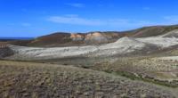
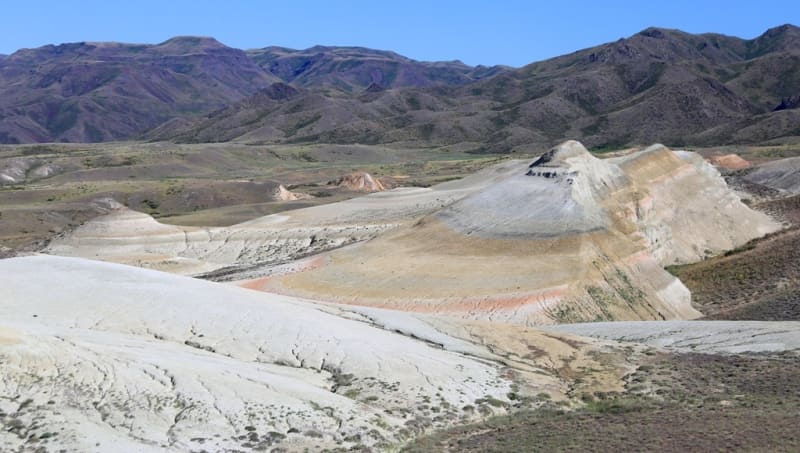
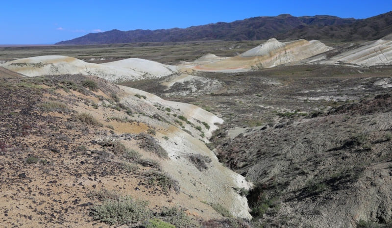
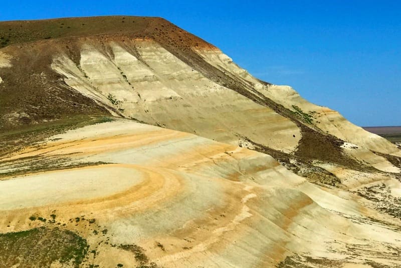
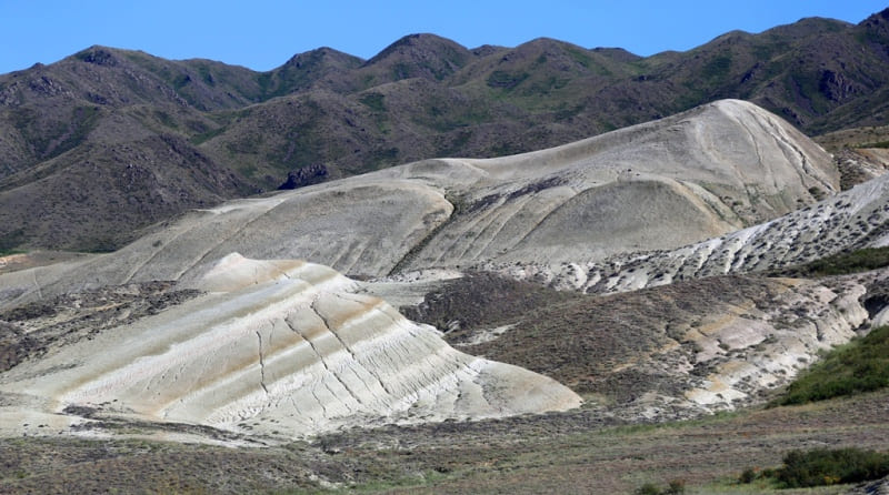
Ridge Manrak.
Mountain ranges of East Kazakhstan region.
“When people ask me why I go on a particular trip, I usually answer: I don’t know, it really is. After all, if I knew what awaits me, I would not set off on the road."
Jacques Yves Cousteau.
Visiting Manrak Mountains in East Kazakhstan.
Manrak Ridge (Manyrak means "bleating sheep") is located 34 kilometers north of the eastern spurs of the Tarbagatai ridge and 12 kilometers southwest of the southern coast of Lake Zaisan in the Zaisan district of the East Kazakhstan region.
The length of the ridge from southeast to northwest is 82 kilometers, the maximum width in the western part of the ridge reaches 43 kilometers. The dominant mark of the massif in the central part is Mount Shorbas, 2046.4 meters high above sea level.
The second highest is Mount Kyzylzharyk with a height of 1951.2 meters above sea level, located 4.7 kilometers northwest of Mount Shorbas. The third highest is the nameless mountain with a height of 1934 meters above sea level, located 2.2 kilometers to the north and slightly to the west of Mount Kyzylzharyk.
The northwestern macroslope of the Manrak ridge is located in the southern part of the Zaisan basin. The mountains are deserted, treeless, with several small rivers flowing into Lake Zaisan. The northern macroslope is represented by several rocky massifs separated by valleys and cut from south to north by the canyon of the Kusta River.
The territory is located in the border zone near the border with the People's Republic of China. From the southern and southwestern sides of the peaks of Shorbas and Kyzylzharyk, the sources of the rivers begin: Sarbulak, flowing in the mountains of Kazanbastau, Makazhan and Zhanakay.
To the north, from under the peaks of Shorbas and Kyzylzharyk, the rivers flow down: Kensai, Zhaman Kusty, Kusty, Kashantai and Tayzhuzgen. The massif of the Manrak Range includes 7 internal mountains. The most northwestern spurs of the range are the Kyzyladyr Mountains with a dominant mountain 828 meters above sea level.
In the south lie the spurs of the Kazanbastau mountains with a dominant mountain 1662.1 meters above sea level. In the southwestern part of the range are the Sengir mountains with the highest elevation of 1123 meters above sea level.
From the north, the Manrak Range is limited by the Karsakbas Mountains with a dominant height of 1315.3 meters above sea level. The northern spurs of the Karsakbas mountains are two peaks: Mount Zhalgyztobe with a height of 1238.2 meters above sea level and Mount Airshoky with a height of 1093.1 meters above sea level.
In the central part of the ridge, a little south of the Karsakbas mountains, there is a ridge of the Bolatkyzyl mountains with a dominant elevation of 1367.6 meters above sea level. At the head of the Ulken-Sagandyk River are the Zhamanbay Mountains with the highest mountain 1504.9 meters above sea level.
To the north-west of the Zhamanbay mountains are the Kurpebay mountains with a dominant elevation of 1180 meters above sea level. In the northwest, the boundary of the ridge is the valley of the Espe river, in the west the valley of the Kandysu river.
The eastern border of the Manrak Range is the valley of the Uydene River with the reservoir of the same name. Between the northern spurs of the eastern part of the Tarbagatai ridge and the southern tip of the Marnak ridge is the Shilikty valley, which is the watershed for the rivers Chagan-Obo and Kandysu.
The climate in the Manrak Range is sharply continental with large daily air temperature amplitudes. According to climatic conditions, the territory of the mountains belongs to the desert-steppe dry and alpine tundra-meadow zones.
Summers are dry and hot, winters are cold and harsh. The average annual rainfall is 281 mm. The average annual air temperature is −4°C. The absolute minimum temperature falls on January -50°C, the absolute minimum in July is 46°C.
The duration of the frost-free period is 130 - 150 days. Snow cover is established in the second half of November, converges in early April. The average height of snow cover by the end of winter reaches 20 - 30 cm, with fluctuations in some years from 5 to 40 cm.
In the Manrak Ridge there is the Tarbagatai State Nature Reserve on an area of 240,000 hectares. In the Manyrak Ridge and its foothills, 18 nesting territories of Saker Falcon (Falco cherrug) were found, of which 12 are located on the northwestern macroslope on the IBA.
In recent years, the number of breeding pairs has decreased. On rocky areas, the steppe kestrel (Falco naumanni) is common, the number of which in this mountain range reaches 50 - 70 pairs, the steppe harrier (Circus macrourus) nests annually.
In addition, nests of the short-toed eagle (Circaetus gallicus) were found here in different years, golden eagle (Aquila chrysaetos), steppe eagle (A. nipalensis) and imperial eagle (A. heliaca), eagle dwarf (Hieraaetus pennatus) were encountered, hybrids of long-legged buzzard (Buteo rufinus) are common and the Upland Buzzard (Buteo hemilasius). In total, 121 species of birds were recorded during the 8-year period of research on the Manyrak Ridge.
Geographic coordinates of Manrak Ridge: N47°24'09.42" E84°17'05.75"
Authority:
Alexander Petrov.
http://database.acbk.kz/iba_view.php?iba=121
Photos by
Alexander Petrov.