


![]()
You are here
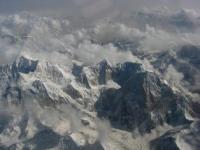
Relief of Pamir-Alai mountains.
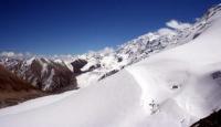
Climbing tour in Tajikistan.
“The world is a book and those who do not travel read only one page”
Augustine of Hippo.
Take a ride in Tajikistan.
The northern ranges of the Pamir-Alai system are the Alai and Turkestan ranges that border the Ferghana Valley from the south. Both ridges are noticeably asymmetric: their southern slopes are steep, the northern ones are accompanied by advanced ridges (Kichik-Alai, i.e., Small Alai, and others).
From the line of the Alai and Turkestan ranges in the area of the Matchinsky mountain junction (altitude more than 5600 m. a. s. l.), the Zeravshan ridge leaves, which stretches west to the south of Zeravshan. Alai, Turkestan and Zeravshan ranges carry numerous glaciers.
These ridges are characterized by serrated ridges, sharp peaks, mountain glacial landforms. An exception are the western parts of the Turkestan and Zeravshan ranges, average heights and mostly flat tops. Here, due to less elevation, ancient alignment surfaces have been preserved. In the westernmost spurs of the system of northern chains of the Pamir-Alai (the Nuratau ridge and others), ancient alignment surfaces are also traced, raised due to tectonic movements and dissected by younger gorges.
From the high icy ridge of the Zeravshan ridge, a powerful Gissar ridge leaves from the southern side. This entire system of the northern Pamir-Alai ridges belongs to the zone of Hercynian folding. Their geological history is identical to the geological history of the southern spurs of the Tien-Shan.
These ridges of the so-called Gissar-Alai system are composed of sedimentary and metamorphic rocks of the Paleozoic with the inclusion of large intrusions (granites, diorites). The modern relief of the ridges is the result of the latest uplifts occurring in the Neogene and Quaternary.
The studies of N. A. Gvozdetsky in the northern advanced parts of the Alai ridge, the western part of Turkestan and in the extreme western spurs of the entire system showed that the concept of S. S. Schulz is applicable to the northern Pamir-Alai ridges, as well as to the Tien-Shan that the tectonic formation of the relief is associated with the formation of folds of large radius.
In the Paleozoic limestones of the northern Pamir-Alai ridges, karst phenomena are developed, mainly caves (Kan-i-Gut cave with huge halls in the northern front ridge of the Turkestan ridge, caves in the advanced parts of the Alai ridge and in the Osh mountains of southeastern Ferghana).
In the western part of the Zeravshan Range, southwest of Urgut, a typically pronounced karst landscape with craters is observed, similar to the landscape of Crimean caves. Here, on the Kirktau plateau, recently discovered the deepest in Central Asia, 950 meters deep and one of the deepest karst abyss in the world in Kiev.
The areas of the Pamir-Alai, located south of the described Gissar-Alai system, are heterogeneous in tectonic respect. To the south of the Gissar Range is the West Tajik Depression (it is also called the South Tajik). In the west, it is bordered by the spurs of the Gissar Range.
Most of this territory, according to modern concepts, belongs to the Epigercin platform and has the folding of the Mesozoic and Cenozoic cover associated with movements along the fault lines of the Hercynian base. These faults and folds of the Mesozoic and Cenozoic cover extending from the northeast to the southwest do not coincide with the latitudinal strike of the Hercynian base structures, but correspond to the strike of the structures of the western part of the adjacent Pamir region of the Alpine geosynclinal region (Cenozoic geosynclinal Tethys) their education.
Only comparatively a narrow strip in the east of the depression (and not the entire depression, as before) is now attributed to the zone of the Pamir marginal trough of the Alpine geosynclinal region.
In West Tajik Depression.
There are many relatively low folded ridges stretching from the north-east to the south-west and south-south-west, slightly curved and convex to the north-west. Ranges are composed of Mesozoic (mainly Cretaceous), Paleogene and partially Neogene sedimentary strata with a large role of carbonate and sand and clay motley colors of rocks.
Structural relief forms are typically expressed, especially cuestar ledges. The valleys, slopes, and often the crests of the ranges are composed of terraces. In limestone, gypsum and saline rocks, karst phenomena are developed. Significant sizes (up to 3 kilometers of total length) and drip and drip formations of gypsum and marble onyx stand Karlyuk caves in the Kugitangtau ridge.
The folded structures of the Pamir region of the Alpine geosynclinal region are separated from the Hercynian structures of the northern tectonic zone of the Pamir-Alai by a system of deep faults, which are associated with earthquakes of the Surkhob valley.
Blockages - deposits of deadly rocky mudflows, breakdowns and landslides of the earthy weathering crust - were buried during the 1949 earthquake in the ancient Tajik city of Khait and the villages of the Yasman Valley. In the Pamir region of the Alpine geosynclinal region, several tectonic zones are distinguished, which extend almost latitudinally, but in the west (in the area of the Peter the Great and Darvaz ranges) they deviate to the south, forming an arc facing the bulge to the northwest.
The outer zone of the Pamirs is formed by continental lagoon, less often marine sediments of the Mesozoic and Cenozoic up to 8 - 10 kilometers thick. In the lower Mesozoic, effusives are developed. Sedimentary strata participate in intense folding, numerous formations.
The Northern Pamir is composed of sedimentary metamorphic and volcanic rocks of the Paleozoic with Hercynian intrusions of granitoids. This is a large anticlinorium with anticlinal and synclinal structures of the second order.
The Central Pamir.
Is characterized by the presence of almost all systems of the Paleozoic and Mesozoic, while the Mesozoic is represented by marine (including carbonate) and lagoon and continental fractions. There are volcanic and sedimentary deposits of the Paleogene. Intensive development, complex folding affected not only the Mesozoic, but also Paleogene deposits. Arrays of granitoids are mainly of late Mesozoic age.
The Southwestern Pamir.
is formed by deeply metamorphosed Precambrian rocks - gneisses, crystalline schists, marbles, granitoid intrusive bodies. This zone is a large anticlinorium. The Southeast Pamir is an area of development of the Upper Paleozoic and marine Mesozoic with significant participation of limestone.
The sedimentary strata form relatively simple folded structures, elongated to the east-southeast and complicated by longitudinal surface formations (M.V. Muratov and I.V. Arkhipov, 1961). B.A. Petrushevsky (1961) includes the South-Eastern Pamir in the Central zone, which he calls the Middle Pamir Synclinoria, while the South-Western and Northern Pamirs calls the South Pamir and North Pamir meganticlinorium zones.
Thus, the ancient Pamir rocks (gneisses with crystalline schists and Paleozoic sedimentary-metamorphic strata) are confined to uplift zones, i.e., they are exposed in the highly elevated anticlinor kernels of the Alpine geosynclinal region. The Cenozoic fold-forming movements of the Alpine geosynclinal (Cenozoic geosynclinal Tethys) were accompanied by powerful uplifts and denudation of folded ridges, which created a modern relief.
The ridges of Peter the Great and Darvaz directly belong to the Pamir Highlands, including their eastern parts, and belong to the two northern zones of the Pamir region of the Alpine geosynclinal region. The ridge of Peter the Great is composed (with the exception of the eastern section) of the Mesozoic and Cenozoic sediments..
Its northern slope has clear levels of leveling surfaces, on which karst phenomena (in Mesozoic limestone and gypsum) are clearly expressed in many areas.
The Pamir Highlands.
Or the Pamir proper, is located in the east of the Pamir-Alai mountain system, south of the Alai valley that separates the Alai and Zaalai ranges. On the Pamir map, it has the characteristic shape of a quadrangle. The greatest heights are located at its edges.
The northern border of the Pamirs is best carried along the foot of the Zaalai ridge, the southern border along the Pyanj and Vakhandarya rivers (attaching the entire Vakhan ridge to the Pamir), then along the left source of Tashkurgan. In the east, the Pamir includes the Sarykol Range and the Kashgar Mountains with the highest altitudes in the entire Pamir (the peak of Kongur is 7,579 m. a. s. l. and Muztagata peak is 7,555 m. a. s. l.
In the west, the border should be drawn along the Panj valley and then north of the main bend of the river ( a little east of 71 ° E) so that the highest, eastern, parts of the Peter the Great and Darvaz ranges belong to the Pamir. The Zaalaysky ranges in the north, Kashgar and Sarykolsky in the east, Vakhansky and its western extension - the Shahda ridge Rinsky in the south, the high ridges of the Western Pamir, abutting against the ridge of the Academy Nauk, form the elevated edges of the Pamir Highlands.
Some researchers (KV Stanyukovich, E. M. Murzaev) suggested that the Pamir be called only its eastern half, based on the peculiarity of its landscapes and referring to one of the first researchers of the Pamir - the geologist D. L. Ivanov.
However D. L. Ivanov does not belong to the priority in the study of the Pamirs, and his article “What should I call the Pamirs?” (1885) refers to the time when the mountains Central Asia were still about Shade poorly understood and when it was not only natural but also the inevitable inconsistency in the use of their own geographical names.
However, after the territory was covered with topographic surveys and more correctly depicted on geographical maps, the signature "Pamir" lay exactly in the quadrangle, the borders of which we just outlined, and laid, of course, not by accident.
Despite the sharp differences in the relief of the Western and Eastern Pamirs, the Pamirs clearly acts as an integral orographic unit, the commonality of which is manifested in the eccentric arrangement of the highest heights (K.K. Markov, 1935), i.e., in the elevation of the mountains along the outskirts of the Pamirs.
And if in later studies it turned out that the Eastern Pamir in its natural features is very different from the neighboring mountainous regions, in particular the Western Pamir, it would seem that there should be only one conclusion from this - to single out the Eastern Pamir as a special physical and geographical region without confusing the use of geographical names.
We must also bear in mind the dismemberment of the eastern edge of the Pamir - Kashgar Mountains and note that the name "Eastern Pamir" is used rather conditionally, only in relation to our territory of the Pamirs. If we take the Pamir Highlands as a whole with its foreign eastern part (with the Kashgar Mountains), then the well-known symmetry will be restored and the Eastern Pamir will soon become Central, as some researchers call it (K.K. Markov, O.E. Agakhanyants).
The strongly icy ridge of the Zaalai ridge rising in the north of the Pamirs (Lenin peak is 7134 m. a. s. l.) significantly exceeds the Alai ridge stretching north and other ridges of the Gissar-Alai system. N.L. Korzhenevsky calculated that the average height of the ridge Zaalaysky ridge even surpasses the ridge of the Academy Nauk and is, therefore, the highest ridge of the Central Asian part of the Pamirs.
In the eastern part of the Zaalaisky ridge, a road was laid through the notch of the Kyzylart pass leading into the Eastern Pamir and further west to Khorog (Osh-Khorog tract). The Zaalaisky ridge, belonging to the external tectonic zone of the Pamirs, is composed of Mesozoic and Cenozoic deposits.
Gypsum karst is quite widespread on its northern slope and at the foot. The internal territory of the Pamirs, lying south of the Zaalai Range, according to orographic features, is sharply divided into two parts: the Western Pamir and the Eastern Pamir, conditionally called by tradition.
The Western Pamirs are characterized by a system of high ridges of a southwestern and almost latitudinal direction, separated by deep valleys and gorges. These are the ridges of Peter the Great and Darvaz (their eastern segments), as well as Vanchsky, which are connected in the east with the meridional ridge of the Academy of Sciences; to the south - the Yazgulemsky, Rushansky, Shugnansky and Shakhdarinsky ranges.
The northern of these ranges and the ridge of the Academy of Sciences belong to the tectonic zone of the Northern Pamirs, Vanchsky, Yazgulemsky - to the Central Pamir, the last three ranges - to the South-Western. In the Western Pamirs is the highest peak in Central Asia - the Peak of Communism, 7495 m. a. s. l., rising in the ridge of the Academy of Sciences at the junction of the Peter the Great ridge.
This peak rises next to the Fedchenko Glacier, the largest in the region and one of the largest mountain valley glaciers in the world. At the junction of the ridges of Peter the Great and the Academy Nauk is the Pamir firn plateau - the remainder of the ancient leveling surface, raised to a height of more than 6000 m. a. s. l.
Of the southern ranges of the Western Pamirs, the highest are Rushansky (Pathor peak - 6080 m. a. s. l.) and Shakhdarinsky (Karl Marx peak - 6726 m. a. s. l.). Erosive, gravitational and other denudation processes in the Western Pamirs reach exceptional intensity.
The Eastern Pamir is characterized by completely different orographic features. Here, essentially in the central part of the highlands, the ancient relief is well preserved (K.K. Markov, M.V. Muratov), while on the western and eastern outskirts of the Pamirs - in the Western Pamirs and Kashgar mountains - it is mainly destroyed by a deep cutting from the edges of mountain gorges and glacial and nival processes.
The relief of the Eastern Pamirs is characterized by flat bottoms of vast valleys and hollows, raised to a huge height - 3500-4500 m. a. s. l. Ranges and mountain ranges rise above them, sometimes reaching heights of more than 6,000 m. a. s. l. (the peak of Soviet Officers on the Muzkol Range is 6,233 m. a. s. l.).
In the north-eastern part of the Pamirs there are large flat drainage basins with lakes. The basins and wide flat valleys of the Eastern Pamirs are filled with products of mountain destruction - fine earth, gravel, pebble, sand, piles of ancient moraines.
Permafrost is found in soils. The slopes of the mountains are dressed with rubble and eluvial boulder loam (K.K. Markov, 1935). Ranges dividing wide valleys, with enormous absolute heights, are often named relatively small relative heights and resemble the mid-mountain ranges.
The highest ridges have sharp mountain glacial forms (this is a young structure against the general background of an ancient relief).
In the Eastern Pamirs.
The Karakul Lake basin belongs to the tectonic zone of the Northern Pamirs, the Muzkol Range and the Rangkul Lake region belong to the Central zone, the Oksu River basin belongs to the Southeast Pamir zone. In different regions of the Eastern Pamirs (basin with lakes Shorkul and Rangkul, Nizatash pass) among the mesoforms of the ancient relief, limestone remains attract attention that N. A. Gvozdetsky is inclined to consider as relict forms of the tropical karst formed in the Oligocene and, possibly, in Miocene in climate and savannah landscape.
So, the Pamir-Alai mountain system is heterogeneous in surface structure. Northern chains (Gissar-Alai system), closest resembling the Great Caucasus in terms of relief and glaciation forms. West Tajik depression with relatively low ranges and structured landforms.
Powerful Zaalaysky ridge and strongly dissected and high Western Pamir. The high, less dissected highlands of the Eastern Pamirs are all different geomorphological regions. The main orographic units are the Gissar-Alai system, the West Tajik Depression and the Pamir.
Authority:
N.A. Gvozdetsky, N.I. Mikhailov. “Physical geography of the USSR. Asian part. Third edition, revised and supplemented. Moscow "Thought" 1978.