


![]()
You are here
Petroglyphs of Suuk-Dobo and Baychechekey.
Rock Art Tours in Kyrgyzstan.
“...it seemed a part of her life, to step from the ancient to the modern, back and forth. She felt rather sorry for those who knew only one and not the other. It was better, she thought, to be able to select from the whole menu of human achievements than to be bound within one narrow range”
Orson Scott Card.
Petroglyphs Walking Tour in Kyrgyzstan.
Suuk-Dobo (Kyrgyz for “cold hill”), coordinates: 73 45 52.6; 40 49 20.0 and Baychechekey (Kyrgyz for “snowdrop”), coordinates 73 45 16.2; 40 49 09.3, are located on the southwestern slopes of the Uzgen Range at an altitude of 3,194m (Suuk-Dobo, peak1) and 2,797m (Baychechekey-Kyr, group II), 40km to the north-east of Uzgen, 15km to the east of Salamalik village.
Administratively, most of the sites are in county Kolduk, a small site in the Salamalik village. The population of the villages uses the territory in a traditional manner, as summertime pastures - dzhayloo. Research Status. First information about Suuk-Dobo and Baychechekey petroglyphs was provided by a school teacher, Zhumabaev B., from Salamalik.
In 2002 – 2005, the sites were surveyed by an expedition from OshSU led by Maltaeva K.Zh. At both sites, stones with petroglyphs were numbered (numbers painted on stones), individual concentrations of drawings were identified (six groups in Suuk-Dobo, several in Baychechekey depending on their location (on the crest, slope, foothill, etc.).
Petroglyphs were registered from west to east; a total of 1,352 drawings on 678 surfaces were registered. Photos of over 300 drawings and scenes were taken; contact copies of 500 drawings were made on polyethylene film.
Burial mounds, “obo”, remains of stone structures (“tashmechet”) and epigraphic sites were discovered. Tentative results of the works were published (Maltaev et al. 2002: 70) and field data kept at the Department of History and Philosophy of OshSU (Osh); reports of the expedition are stored in the archive of the Institute of History and Cultural Heritage NAS of the RK (Bishkek).
According to the first researchers, the most ancient drawings (between IIIrd - IInd millennia BC) include “geometric”- style drawings with analogues among Saymaly-Tash petroglyphs (goats and oxen); individual contour drawings of oxen resemble Tamgaly Bronze Age petroglyphs.
Several chariots, one of which driven by horses, date to the Bronze Age. In the multi-figure compositions, the authors single out “the sun-headed”, “masks”, erotic scenes, birthing women, and solar signs. In general, Suuk-Dobo and Baychechekey petroglyphs date to the period from the Bronze Age to the Middle Ages inclusively.
This said, the sites are considered as a full analogue of Saymaly-Tash according to their location at high altitude, number, age, and artistic peculiarities. Under the UNESCO Project of preparation for the serial nomination “Sites of Rock Art in Central Asia” in 2009, surveying and documentation of Suuk-Dobo and Baychechekey petroglyphs was continued by the South-Kyrgyz Archeological Party of the IHCH of NAS of the RK led by Amanbaeva B.E.
Geological samples were collected and submitted to the South-Kyrgyz geological expedition at Osh City for determination. Geological exploration was carried out east, south-east, and north of the main petroglyph locations. Suuk-Dobo is located on a mountain range with the same name, a northwestern spur of the main Uzgen Range.
The range stretching from south-east to northwest has three peaks and four vents. Indexes for stones with petroglyphs were done according to the terrain: drawings on each peak and vent make up individually numbered groups.
The main concentration begins on the second peak; there also are plenty of petroglyphs on vents. Another range - Baychechekey– is close to the Suuk-Dobo range in the south-west, also stretching from north-east to south-west; in its middle the range changes direction inclining west by 10º.
It has about 15 peaks at intervals of 8 - 10m to 60m. Two parts of the site have provisionally been identified: the western and eastern parts which include peaks adjoining Suuk-Dobo. Petroglyphs are primarily located on rock outcrops along the range as well as on its north-western and northern slopes, along 2.5 km.
The sizes of drawings vary from 4 - 5cm to 1m. On five peaks in the western part of Baychechekey, Obo - landmarks used by sheep herdsmen– are piled up from rock debris. Ruins of tash-mechet (“stone mosque”), comprising seven rooms, one of which still contains a ceiling made with juniper logs and stone slabs, are 3.5 km east of Suuk-Dobo.
Arabic inscriptions as well as modern Cyrillic inscriptions are found on its walls. Tash-Mechet is a pilgrimage site for the local population from adjacent and remote settlements in the Uzgen and Kara-Kulzhi districts. Two round earth and stone burial mounds, 10m and 12m in diameter and about 0.3m high, were registered near tash-mechet and are supposedly dated to the Early Iron Age.
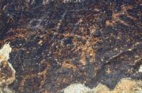
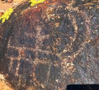
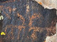
Repertoire of Petroglyphs. Suuk-Dobo rock art can be divided into the following groups according to its motifs: humans (gesticulating or in relaxed poses, archers in hunting and battle scenes, riders, “the sun-headed”, a mask); animals (mountain goats, camels, horses, ox, deer, predators, snakes (?)); geometric signs (concavities, solar signs, in the form of a “bird track” and others).
Inscriptions by modern visitors are in Cyrillic. Scenes include mountains goats chased by predators (dogs, leopards?), marching goats, an archer hunting animals with a dog, camel-riders, and others. A depiction of two male personages with bunches of twigs in their hands performing some acts over fire are of special interest.
Compositions of geometrics – circles, irregular closed shapes, crooked lines, etc.– are commonly found, as well as palimpsests, refreshed and incomplete drawings. It should be noted that the repertoire of petroglyphs is diverse, but that, contrary to the first researchers’ opinion, Suuk-Dobo is next to Saymaly-Tash for the quantity of its petroglyphs and its most ancient drawings.
“Geometric” animal drawings in the “bitriangonal” style are sporadic; Bronze Age drawings, late at Saymaly-Tash, are dominant. At the same time, some drawing traditions poorly represented at Saymaly-Tash distinctively stand out at Suuk-Dobo.
The repertoire of petroglyphs at Suuk-Dobo and Baychechekey is quite similar. Two horse-driven chariots (one with disk-like wheels) were found in the eastern part of Baychechekey. Rare drawings include horses resembling “Davanian” horses in a style found among Ayrymach-Too (Surottu-Tash) petroglyphs and at Aravan.
An original tamga and the drawing of a possible opium poppy are notable. Most Suuk-Dobo and Baychechekey petroglyphs can be dated from the Early Iron Age to the Middle Ages inclusively, but earlier and later images may be present.
The latter may include Rock Art in Central Asia 56 primitive line drawings of goats, tamgas and Arabic inscriptions. We cannot date a mask, “the sunheaded” personage and some geometric shapes combined with concavities. In general, the repertoire and age of most Suuk-Dobo and Baychechekey petroglyphs may make of those sites a connecting link between the high-altitude locations in the Fergana and Uzgen Ranges and drawings in the low hills. Technique.
Suuk-Dobo and Baychechekey petroglyphs are made by coarse-dot and fine-dot (0.5mm to 4 - 5mm deep) chipping; a combined technique of pecking and engraving, with a depth of no more than 1mm, is rarer. Arabic inscriptions were engraved. Current Condition and Protection.
The condition of the petroglyphs on the two eastern peaks of Suuk-Dobo is satisfactory, as they are very remote from the traditional places of summertime encampments of herdsmen. The western edge of Suuk-Dobo and the eastern part of Baychechekey are intensively visited from July to mid-September, when shepherds bring their herds to summertime pasture.
This is also the time for increased visits of pilgrims, who perform worship rituals near “tash-mechet” and Lake Kok-Kol (Uzgen and Kara-Kulzhi districts). Damage to petroglyphs due to natural factors have been noted: wind erosion of rock surfaces, detachment of patina, moss and lichen growth, and others.
The boundaries and protection zones have not yet been identified for those sites; their physical protection is nonexistent. They are not included in official lists. Nominally, the local authorities and the State Agency for Culture of the RK are responsible for their protection.
Authority:
«Rock Art in Kyrgyzstan». Bakyt Amanbaeva, Aiday Suleymanova, Chynarbek Zholdoshev.
Photos by
Alexander Petrov.