


![]()
You are here
Petroglyphs of Sulayman-Too.
Tours Petroglyphs Osh region.
“He who conquers himself is the mightiest warrior”
Confucius.
Сave drawing of Southern Kyrgyzstan.
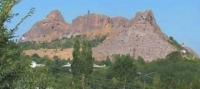
Mount Sulayman-Too (Takhti-Suleyment, Takhti-Sulayman, Sulayman-Tag) is in the center of Osh – the second city in Kyrgyzstan by size and importance. Geographic coordinates: NL 40 31 19; EL 72 45 01.64; altitude 1,175.3m; relative altitude 191.3m.
The mountain is 1,663m long and 476m (first peak) to 820m (third peak) wide. On the map, the mount has an irregular oval shape that stretches east-west; it mainly consists of marble-like limestone with occurrence of siliceous shale.
Mountain Sulayman-Too has five peaks, each with a name:
1st: Buura-Tag (Kyrgyz for “camel-mountain” or Sulayman-Too – “Sulayman’s Mountain”); the latter gave the name to the entire mountain;
2nd: Shor-Too (Kyrgyz for “Salty Mountain”) – the southern slope of the second peak named for its white salt efflorescence, while the northern slope is Kochotluk-Too (Kyrgyz for “Sliding Mountain”);
3rd: Rusha-Too (Kyrgyz for “the tallest” or “the brightest”) is the highest peak of the mountain;
4th: Kattama-Too (Kyrgyz for “layered mountain”) reflecting its folded structure;
5th: the peak is isolated from the others and consists of two individual parts – one called Kelinchek (Kyrgyz for “daughter-inlaw”), also called Eer-Too (Kyrgyz for “saddle mountain”) since its shape resembles a saddle, while another one is called Keklikuchar – the peak where “partridges fly”.
Petroglyphs were registered on all peaks as well as caves, overhangs, karst tunnels located on mountain slopes. The drawings are mainly found on the eastern, southern, south-eastern, and south-western slopes of all five peaks both on open and closed surfaces.
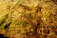
They are grouped with regard to altitude, orientation of rocks towards cardinal points, terrain and location of other sites. There is a total of about 400 drawings, but we do not know their exact number. Motifs. From their content, the petroglyphs can be provisionally grouped into three categories: human, animal, and geometric signs of different forms.
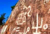
The largest group consists of solar symbols (a circle with a dot, with spokes and a circle with diverging rays), crosses, squares, arrows, "commas", tree-like pictures, triple forks (bird tracks) and "web". Humans include archers, masklike images and foot.
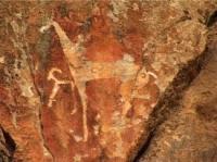
The second group is more heterogeneous and comprises mostly single images, for example, single solar symbols, or unique petroglyphs. These include realistic portrayals of three horses held by a man with a long rope and archers shooting at each other on the southern side of the Eer-Too peak.
Images of animals at Sulayman-Too are few: horses, snakes with open mouths, predator birds, goats with curved horns and sometimes with their legs tied. Most petroglyphs are unique both in style and motif. Technique. Petroglyphs were drawn using stone and metal implements on horizontal, vertical, sometimes inclined surfaces of rocks or on separate stone blocks using pecking, engraving and abrading techniques.
Drawings are made in different manners: outlines, contours and linearschematic. In addition, the techniques are consistent with the style dated to different historical epochs. Engravings can mainly be found on the walls and ceilings of caves and overhangs. Here is a description of some sites at Sulayman-Too.
Chilten Khan is a cave on the south-western slope of the second peak; the name translates as “abode of spirits”. Chiltens, the mysterious spirits that help people and their cult are widely distributed in Fergana. There are three entrances to the cave: one from the northern slope, the second from the south and the third from the cave complex.
The length of the main, west entrance is about 50m with a long -about 30m- karst tunnel whose floor is lined with stones and red clay heading northward from the entrance, so another name for the cave is the Kyzyl-Unkur (Red Cave). Some signs – squares and circle- carved at the beginning of the tunnel were described by previous researchers (Ogudin et al. 1988: 28) but we were unable to detect them.
Several groups of drawings were registered on the vertical surface to the left near the main entrance to the cave. The first consists of four refreshed circles with a diameter of 7.5 - 8cm on patina-covered rocks at the entrance, 0.23m from the floor. Coarse pecking and 2-2.5cm wide lines.
The diameter of artificial cupules in the middle of circles is 4cm. Four more cupules are 0.3m away. In contrast to the first group, they show no traces of refreshing. Their diameter is 3 to 5cm. Several groups of drawings on the same surface (so-called “webs”) were made with a pointed sharp tool on the patina.
Several small compositions of circles of varying diameters, shamrock, snakes, and various geometric forms – crossing lines, cross-like shapes, and others – were registered. On the wall to the right, in a small side entrance, two chains of cupules are 3.5-4cm in diameter.
Circles are traced in a fine line to their right. Even now, pilgrims burn ritual fires and perform various rites inside the main cave. Locals believe that a passage through this cave leads directly to Mecca. To the right, numerous images are incised in a thin line on top of the patina.
There are single solar symbols, circles up to 25cm in diameter, trefoils, and geometric shapes drawn using a complex tangle of fine lines, spirals, etc. This panel is the largest in size, number of elements and complexity of composition. Similar drawings are on the walls of a small overhang near a site with graffiti mentioned above.
The entrance of a grotto in the south-eastern part of the fifth peak faces north-east and has a maximum depth of 3.5m. The area in front of the entrance is 6m long and 0.5 - 1m high. Its sloping sides and some vertical surfaces are polished from touching by ritual pilgrims.
The first group of drawings, two tree-like shapes with different quantity of offshoots, is carved on the vertical wall to the left in a 0.8x0.7m area at a height of 0.8m above the cave floor. The composition is elaborate with geometrics.
Three solar signs are in various places inside.
Two pairs of foot prints are grooved on the right side of an inclined surface. At the same place near the entrance, there is a tree-like shape with two squares below. A sub-rectangular shape consists of different geometric elements: triangle, circle, point, and others on side surfaces in front of the entrance (to the right).
The rock surface and drawings are covered Rock Art in Kyrgyzstan 61 with patina of the same shade. Outside the grotto, under an overhang, are also two grooved drawings. Two more sites were registered on the northern slope of the fifth peak.
There are “web”- drawings on the northern side and arch of the grotto with an entrance opening to the north-east. The second small group of drawings is found on the walls of a small overhang located somewhat lower than the previous grotto.
The composition consists of cross-like signs and circles with signs in the shape of a comma. Similar drawings are present on other peaks as well. Dating. Sulayman-Too rock art dates to the period from the mid - IInd millennium BC to the first half of the Ist millennium AD (XVth century BC – VIIth century AD).
Most drawings date to the Bronze Age: labyrinths, solar signs, geometrics (rectangles, squares), birds, humans and mask-like figures. Davan horses and some goats date to the end of the Ist millennium BC – beginning of the Ist millennium AD.
Many drawings, though modern, with dates and authors’ names, are artistically drawn: a human, architectural buildings, mountains, a sun with rays, animals. However, some Sulayman-Too petroglyphs are still undated. Specifics of Sulayman-Too Petroglyphs: rarity of narrative motifs; persistent set of signs, presence of multi-shaped compositions with repetitive combination of signs; lack of close analogies for most drawings by style, repertoire and combination; a link between certain groups of drawings with horizontal, vertical, or inclined surfaces; relevance of most petroglyphs to cultic sites; difference in drawing techniques depending on location.
Close analogies with some earlier Sulayman-Too drawings are available among Saymaly-Tash petroglyphs: (few) snakes in a wavy line, goats, labyrinths, geometrics (solar signs as a circle with a dot and spokes, squares, rectangles, and others) (Martynov et al. 1992).
Neolithic drawings in Akbaur grotto in Eastern Kazakhstan are partly similar to Sulayman-Too petroglyph motifs (Samashev 2006). Another analogy: Naydupali petroglyphs located in Andhra Pradesh (south-east India) also feature labyrinths including with a combination of tree-like shapes with geometric shapes.
This category may also include petroglyphs from Northern Italy (Val Camonica Valley) dated to the Early Iron Age (Anati 1968). The closest direct analogies to Sulayman-Too Davan horses can be seen in the Surottu-Tash Mountains, Aravan Rock, and in the Aravan-Say and Abshir-Say valleys (foothill districts of south-eastern Fergana).
Petroglyphs and Cultic Sites at Sulayman-Too.
According to researchers, solar signs, and drawings in the shape of a comma, snake, or footprint are consistent with cultic sites at SulaymanToo. Isolated drawings unique to the site are on tables of oblation – a straight cross and an open palm.
Most rocks with drawings from the first group of motifs are located on vertical surfaces facing east, south-east, and south. Horizontal areas right in front of them are marked with solar signs. Inclined surfaces at Sulayman-Too are mostly devoid of drawings with the exception of those with abraded grooves and strips with chiseled signs in the shape of an open palm, foot, solar signs, and, rarely, arrows.
Most cultic places are at present used by pilgrims for various magic and medicinal purposes.
Authority:
«Rock Art in Kyrgyzstan». Bakyt Amanbaeva, Aiday Suleymanova, Chynarbek Zholdoshev.
Photos by
Alexander Petrov.