


![]()
You are here
Petroglyphs of Sarmishsay.
Welcome to Petroglyphs in Uzbekistan.
“Does progress mean that we dissolve our ancient myths? If we forget our legends, I fear that we shall close an important door to the imagination”
James Christensen.
Historic Petroglyph of Uzbekistan.
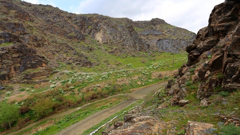
Sarmishsay is located 35km north-east of the city of Navoi in the Novbahor District of the Navoi Region on the southern slope of the Karatau Mountains, northwestern spurs of the Turkestan Range, within the system of the Nuratau Mountains.
They are considered as low mountains, the westernmost in Central Asia. The highest elevation of the Karatau Range is 1200m above sea level (Khujanazarpv 2004:109 - 120). The Nuratau Range encloses the fertile valley of the Zarafshan River and separates it from a sandy desert, the Kyzyl Kum.
The region is considered as a mountain desert with an arid, extreme continental climate. The diverse flora includes nearly 650 plant species, with 27 of them endemic to the region. The southern slopes of the Karatau Range (about 80km long and 700 - 1,100m above sea level) are dissected by the erosion valleys of the Zarafshan River tributaries.
The largest valley –Sarmishsay– originates in the highest part of the mountains and stretches for 30km. Sarmishsay stands out among the Karatau valleys due to an especially favorable living environment both for nomadic pastoralists and settled farmers. Research Status.
The Sarmishsay petroglyphs were studied for the first time by archeologist Kh.I. Mukhamedov in 1958 and then researched by Uzbek scientists, N.-Kh. Tashkenbaev (Tashkenbaev 1966) and Zh. Kabirov (Kabirov 1976).
Since the 1980’s, all research in Sarmishsay and the Nuratau Mountains has been carried out under the guidance of M. M. Khuhanazarov in partnership with Uzbek and foreign specialists. During the last decade, a Polish archeologist, A. Rozwadowski (Rozwadowski 2003, 2004) and a zoologist, A. Lasota-Moskalewska (LasotaMoskalewska & Hujaanazarov 2000), have participated in the research.
Since 2003, a program of comprehensive scientific research and conservation has been underway in the framework of an international Uzbek-Norwegian Project “Management and Sustainable Conservation of Sarmishsay” led by M.M. Khujanazarov (Uzbekistan) and Anne-Sophie Hygen (Norway).
Botanic research is led by K.N. Toderich, while M.A. Reutova (Uzbekistan) is in charge of conservation activities in partnership with E.N. Ageeva, N.L. Rebrikova (Russia) and Ch. Gran (Norway) (2004). In addition, in 2004 - 2005, geological and geomorphological studies (B.Zh. Aubekerov, Kazakhstan) were carried out with Uzbek specialists under the auspices of UNESCO to identify and document petroglyphs and other sites in the complex (Rogozhinskiy, Kazakhstan).
Limited archeological excavations were undertaken at several Sarmishsay sites in 2004 - 2005 (Khujanazarov & Toderich 2005; Khujanazarov, Toderich, Reutova 2006). Ethnological information is also being collected and recorded.
The researchers developed a common chronology for the Sarmishsay petroglyphs on the basis of stylistic differences between the images and stratigraphic observations, and the differences between technique and color of varnish; dating of identified series of images is based on comparison with artefacts (weapons, tools), works of art from archaeological sites (the painted pottery of the Middle East and Central Asia), as well as on a comparison of the repertoire of zoomorphic images with paleo faunistic data (Lasota-Moskalewska & Hujanazarov 2000).
However, the typology of the Sarmishsaya petroglyphs has not yet been developed and a detailed periodization is non-existent; dating the most ancient groups of rock art is still highly questionable: Neolithic, Eneolithic, or Bronze Age?
Other sites of the complex are still poorly researched, since their identification and detailed mapping has only begun in recent years and has not yet been completed. An integrated approach to research and conservation at Sarmishsay has in recent years helped gain more knowledge about the scope and cultural-historical value of the site.
The amount of data pertaining to archeology and the natural sciences has significantly increased and the quality of the available documentation improved (special maps, indexed panoramas of the main groups of petroglyphs, documentation of conservation activities and status monitoring of petroglyphs, etc.); a modern approach of evidence-based sustainable management of the site is taking shape.
All are prerequisites for a successful nomination of Sarmishsay on UNESCO’s World Heritage List in the future. Archeological Context. The archeological context of Sarmishsay comprises more than 200 ancient settlements, burial sites, and concentrations of petroglyphs massed in the middle of the valley on an area of about 35km2 .
The settlements include a large number of dwelling sites with permanent buildings, fortified settlements and tepa, ruins of unfortified rural settlements. According to the excavations and to the collected artefacts, the known sites range from Middle Ages and modern times (IInd century BC – XVIIIth - early XXth centuries).
The ruins of two or three rural settlements (kishlaks) in existence until 1940 - 1950 as well as mills and other household and irrigation buildings remain. Several types of burial sites including earthen and stone-earthen kurgans, ossuary burials in stone crypts (kurums), and stone fences of different forms with earthen burials are dated from Antiquity to the Late Middle Ages.
There are also mazars, places worshipped as shrines or related to the graves of holy men. Paleolithic workshops and Neolithic silicon pits Uch-Tut were discovered in the vicinity of the mouth of the Sarmishsay Valley that links it to the Zarafshan Valley.
Petroglyphs are found practically everywhere in the Sarmishsay Valley, but the most representative concentrations are grouped in a canyon in 15 main groups located on both sides of a gorge and stretching for 2 - 2.5km, where more than 4,000 images have been registered on three types of locations.
Main (located in the canyon featuring images from all periods, many artful engravings, a rich repertoire); peripheral (engravings from one/two periods, a limited repertoire); locations found along traditional communication pathways – pedestrian and bridle roads connecting key functional zones of the cultural landscape: places of settlements dwellings, water sources, and pastures (limited number of images, an extremely poor repertoire, a poor quality of images).
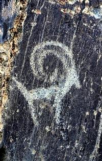
In total Sarmishsay petroglyphs number 6,000 images. They are found either on the vertical and horizontal surfaces of rock outcrops of Red Sandstone of Cambrian Age interlaid with shale and limestone. Sarmishsay petroglyphs differ by age, style and repertoire.
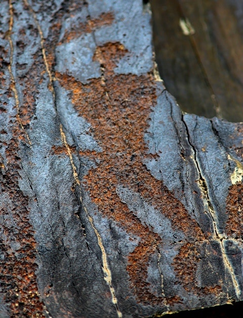
Multi-layered compositions created in different periods and sometimes overlapping often occur. These panels and images that differ in color of varnish help to identify a relative age for the images. The most ancient Sarmishsay petroglyphs are dated to the Stone and Bronze ages (VIth - IInd millennia BC).
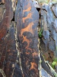
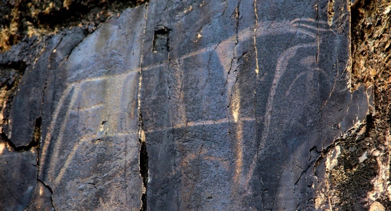
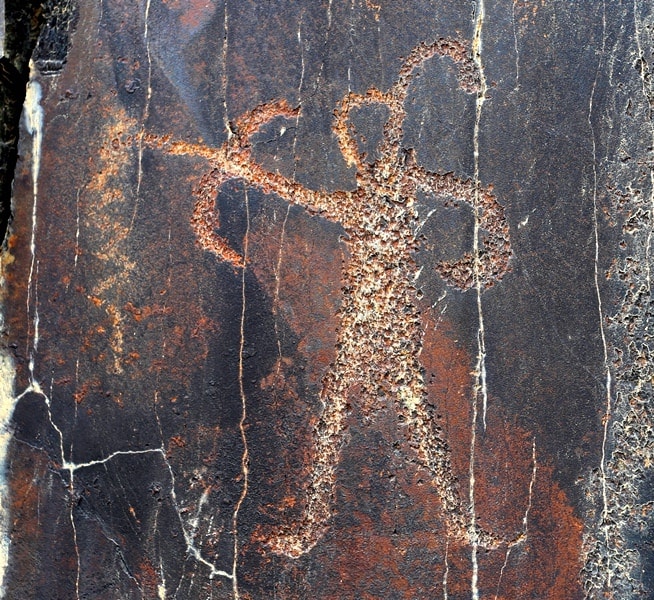
The most ancient layer of these images is characterized by an ox-urus (Bos primigenius). Quite a few images of ox-uruses are in a triangular style. They are dynamic, in a manner intrinsic to ancient hunting cultures that, apparently, has its roots in the art of the Upper Paleolithic.
Similar images were discovered among the Gobustan petroglyphs in Azerbaijan as well as in the central part of the Arabian Peninsula. Skeletal remains of these animals were unearthed in Uzbekistan at ancient archeological sites dated to the Paleolithic, Mesolithic, and Early Bronze Age periods.
The researchers suppose that these animals became extinct or were killed off by people at the end of the 2nd millennium BC. The latter assumption is more likely, since with a transition to nomadic cattle raising, a battle for pastures started, resulting in a mass hunt of animals.
Ancient drawings were carved onto empty convenient rock surfaces, while others occupy secondary parts of rocks and differ in depth of carving and intensity of desert varnish. These drawings also differ in size: on average 30 - 40cm, sometimes up to 70 - 80cm and even larger than 1m.
It could also be noted that most ancient Sarmishsay drawings are strikingly similar in technique and manner, as if created by one artisan. From the analysis of petroglyphs, one can conclude that hunting was vital for the earliest inhabitants of the area.
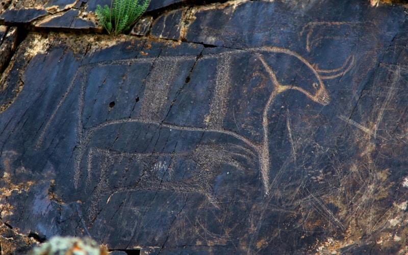
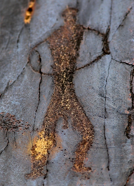
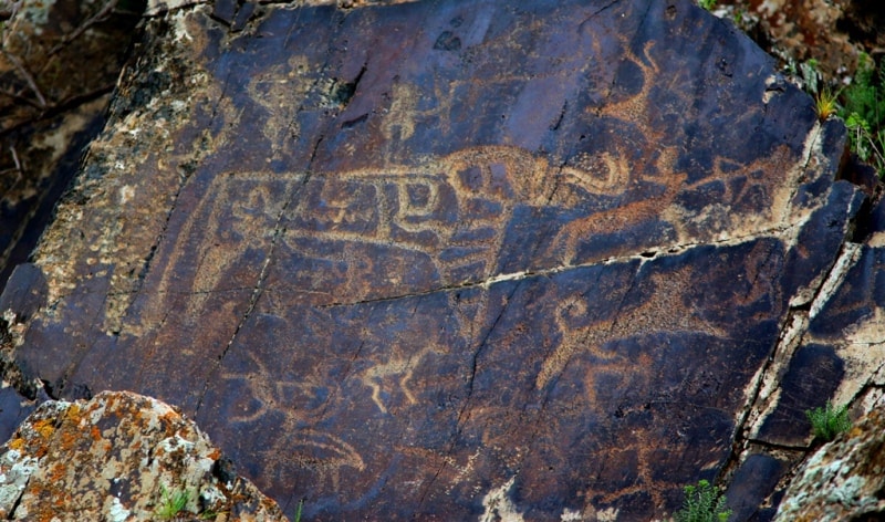
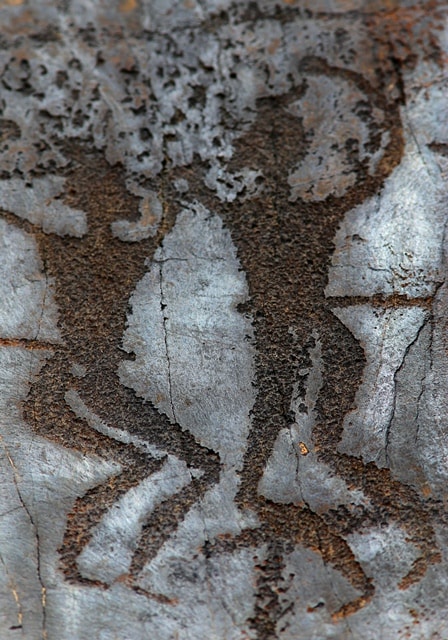
Scenes of hunting wild bulls, mountain goats, and other animals are common. Probably, hunting was also important in the Bronze Age as well. Ancient Sarmishsay images often include various wild animals such as the ox (Bos primigenius), bison, red deer, Asian wild ass, goitered gazelle, predators from the feline family (tiger, lion, leopard, cheetah), mountain goat, wild boar, dog, etc.
At present it is impossible to determine even an approximate date when the above-mentioned animals appeared as petroglyphs in Uzbekistan. It is known that the red deer (Bukhara), Asian wild ass, goitered gazelle, mountain goat, wild boar and others had lived in Uzbekistan at least since the mammoth or the Upper Paleolithic faunal complex.
Currently in Uzbekistan, these animals now live in nature reservations and mountain gorges and are listed in the “Red Data Book”. Together with images of oxen (Bos primigenius) a large series of images of people, animals and some vague shapes are the most interesting for those ancient times.
They depict the life and worldview of ancient people and provide information unavailable from other sources. Animal images from the Early Iron Age have easily recognizable characteristics in whatever material they are represented. Images of oxen (Bos primigenius) and scenes related to the solar cult no longer exist.
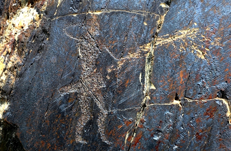
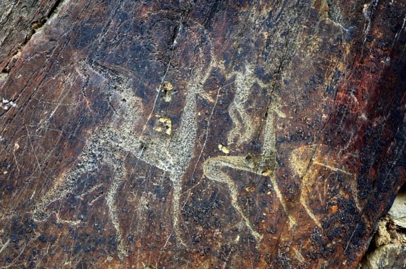
The main motifs of that early nomads’ art include mountain goats, deer, arkhars, predators, horses, camels, dogs, goitered gazelles, and other animals as well as anthropomorphs. Images of horsemen begin to appear, indicative of the Saka-Scythian period. Images of bows, quivers, swords, daggers, head-dresses, traps and different signs are commonly found.
Wild animal hunts, goats or deer chased by predators become the main motifs. The earlier common phallic cult begins to diminish. Exquisite drawings and entire panels of that time appear next to petroglyphs dated to the Stone and Bronze Ages and are often rudely superimposed over them, as if crossing out ancient creations.
The Saka-Scythian petroglyphs are smaller than images of earlier periods. In addition, some drawings do not seem to be related to one another. As in earlier petroglyphs their surface is often covered with desert varnish and blends with the background.
Most Saka-Scythian drawings have been carved with metal tools. The Sarmishsay petroglyphs of this period were created by Saki and Massaget tribes, and other peoples recorded in written sources. In general, the images of that period have similarities throughout Central Asia; a series of specific images (exquisite horse images) are very similar to those at the Fergana Valley sites (Aravan, Surattuu-Tash, Sulayman-Too) and are dated to Antiquity.
A series of petroglyphs dated to the Early Middle Ages stands out. Panels with cultic and epic scenes (worshipping priests near a Zoroastrian fire altar, concoction of a sacred potion and sacrificial offering, royal hunt) are masterpieces of rock art, characteristic of the urban Sogd of the pre-Islamic period.
Such petroglyphs are mainly found in parts of the canyon where there is a necropolis with burials in stone crypts (kurums: between groups V and X) as well as with fortified settlements below the canyon (settlements Sarmishtepa I, II).
In Sarmishsay, along with the ancient petroglyphs, a number of drawings date to a period from the Late Middle Ages to modern times (prior to the XXth century). They are carved in rough ragged lines at a shallow depth and varnish on them is either very light or nonexistent at all.
In most cases, they are simple in execution and not very varied – wild and domestic animals, birds, horsemen, and chilim (smoking devices such as hookahs). Tamga (seal or sign-like) images and Arabic inscriptions found near settlements date to later periods. Current Condition of the Site. Natural and human factors affect the condition of the landscape and of Sarmishsay.
So far, no boundaries of the site have been established and no effective protection provided so that economic activities and uncontrolled visits by tourists and campers are a danger, particularly in the Sarmishsay valley and canyon where the most valuable petroglyphs and a number of other archeological sites are concentrated.
The condition of the landscape and sites is however still satisfactory, particularly as far as the petroglyphs are concerned. At present, Sarmishsay is registered as a site of local significance. The Navoi Region authorities decided to ensure its protection and created a Natural and Archeological Museum-Reserve “Sarmishsay” in 2004 within the Museum of History and Regional Ethnography (Navoi City). A staff of twelve persons (director, research associates, guides, guards) was planned.
However, the reserve has not yet been allotted the funds to implement the decision of the local authorities, so no people have been hired, nor does the state-authorized agency provide protection. In 2005, Sarmishsay was included in the UNESCO World Heritage Tentative List for Uzbekistan, but its boundaries have not yet been determined.
At present, several small-scale farms (mostly for livestock) operate in Sarmishsay. There is an unpaved road. Below and above the canyon, two children’s summer camps (“Gorniy” and “Sheboda”) house 5,000 people in the summer season (June - August).
In addition, this region’s urban population actively visits the picturesque Gorge in spring and summer for recreation. The site is located along very popular routes for foreign tourists travelling from Samarkand to Bukhara.
Visits to Sarmishsay with rock art sightseeing is included in the program of many tourist agencies’ excursions in Uzbekistan. In recent years, a study group for rock art (“Sarmish”) of the Institute of Archeology (led by M.M. Khujanazarov) has been implementing a broad range of activities and research to arrange for protection and management of the site within the frameworks of the Project “Research, Conservation and Management of Sarmishsay Cultural and Natural Heritage Site” supported by the Norwegian MFA and the Directorate for Cultural Heritage of Norway.
It is also part of the Regional UNESCO Project “CARAD – Central Asian Rock Art Database”. A lot of effort has been made to organize and control visits, to establish tourist routes, improve sightseeing trails, develop rules for visitors, and so on.
Information and communication activities for the local population aimed at explaining the value of the site and the need for its protection are underway. Attempts are being made to involve locals in the protection of the site.
Conservation activities to strengthen the fragile parts of those rocks with petroglyphs, and to remove visitors’ inscriptions and other graffiti have been carried out since 2003.


Authority:
Muhiddin Khujanazarov.
Photos by
Alexander Petrov.