


![]()
You are here
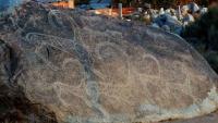
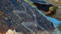
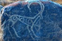
Petroglyphs around Issyk-Kul lake.
Private Tours to Cholpon-Ata Petroglyphs.
“The language of light can only be decoded by the heart”
The Best Petroglyphs Tours Kyrgyzstan.
Northern Tien-Shan Issyk-Kul Basin is located in the north-eastern part of Kyrgyzstan. Its northern border is the Kungey-Ala-Too Range and its south border the Terskey-Ala-Too Range.
The Chu River cuts through the mountains along the Boo Gorge and forms the only natural passage to the piedmont plains in the north of the country. The basin stretches 250km from west to east and 100km from north to south. Lake Issyk-Kul (668m deep) occupies its central part.
The basin terrain consists of two main parts: a coastal piedmont plain and range slopes facing the lake. Several dozens of lakes are on the slopes and Tyup and Zhergalan in the east are the largest. The lake is surrounded with a plain with varying width (40 to 50km in the east, 1 - 10km in the north, and 10 - 15km in the west).
Terraces and foothill slopes formed by merging alluvial cones of mountain rivers are located farther from the coast. Foothills or adyrs surround the valley and rise 300 - 1,000m above the plain. Mountain ranges rise behind them and the Karakol Peak in the Teskey-Ala-Too Range reaches 5,280m.
In the south-east and east of the region, other ranges have even higher altitudes – up to more than 7,000m (Atlas 1987). As in other mountainous areas in the country the climate depends upon the altitude. Lakes influence to a great extent the climate of the adjacent plain. In general, it is characterized by a moderately warm summer and mild winter.
In the coastal area in the west, there is a semi-desert and even desert on brown soils; in the east, steppes on maroon soils. Mountain slopes in the west are devoid of forests, while in the east are spruce forests, especially in the Teskey-Ala-Too gorges.
Administratively, the territory of the basin comprises the Issyk-Kul Province with its capital city, Karakol, and five districts. The polyethnic population numbers 4,206,000 people. Key occupations include agriculture, tourism, mining and processing industry.
Archeological Background The Issyk-Kul Basin was for the first time peopled in the Late Paleolithic (Bozbarmak site); later Stone Age stages are also represented. In particular, a high-altitude cave with parietal paintings, Ak-Chunkur, is dated to the Neolithic.
During the Bronze Age, Near Issyk Kul Area was inhabited by tribes part of the local Semirechensk variety of the Andronovo Historical and Cultural Community. The basin was peopled in the Early Iron Age, as we can tell from many archeological sites found in different parts of the region.
The Late and Advanced Middle Ages are also well represented, at a time when the Near Issyk Kul Area was populated by Turkic tribes that were part of various states. Sites of different types of that period were left both by nomadic and settled people.
Near Issyk Kul Area is also famous for sites of the XIIIth - XVth centuries –Mongolian Period, the Age of Tamerlane and his descendants; in the ensuing centuries, the territory was part of the Zhungar and Kokand khanates (Encyclopedia 1991).
The eastern, southern, and south-western coasts of Lake Issyk-Kul are famous for locations with a varying number of petroglyphs. Some also have rock inscriptions and tamgas. The best-known sites have Tibetan inscriptions and images of the XVIIth - mid XVIIIth centuries in the mountainous valleys of Dzhuuku, Tamga, and others.
Researchers mention the local population using Tibetan prayer inscriptions in the Tamga Gorge in modern cult practices. Cave Ak-Chunkur has rock paintings dated to the Neolithic, in the eastern part of the Issyk-Kul region, in the high-altitude Sary-Zhaz (intermontane trough between the southern slope of the Teskey-Ala-Too and SaryZhas Ranges) (Okladnikov & Ratzek 1954: 447 - 456).
Rock art sites on the northern coast of Issyk-Kul are amongst the most studied and numerous. Northern Near Issyk Kul Area A large group of sites is concentrated in the foothills of the Kungei Ala-Too Range for about 60km along the northern coast of Issyk-Kul.
The most famous clusters of petroglyphs are located near settlements Chok-Tal, Tamchi, Kara-Oy, Chon-Sary-Oi, Sary-Oi, Ornok and the city of CholponAta. The peculiarity of the sites in the region lies in the fact that the images are pecked on the surfaces of boulders (granites and granitoids) covered with patina, concentrated on the giant alluvial cones along the mountain, on the coastal plains.
In addition to petroglyphs, there also are burial grounds, settlements, altars, stone statues and other sites belonging to different historical periods. In general, the Northern Near Issyk Kul Area Region petroglyphs date from the Bronze Age to the Late Middle Ages and Modern Times; numerically dominant are images from the Early Iron Age and Middle Ages.
Information on the total number of locations on the northern coast, as well as around the Issyk-Kul Region, is unclear, as different and very rough figures are available. The most reliable data is apparently that of Nurmametov R.G. who has recently documented petroglyphs in Cholpon-Ata (Nurmametov 2004).
Research Status of the Sites The study of the Issyk-Kul Region petroglyphs has gone on for more than 150 years, but the extent of study of individual locations is different. Since the early 1950’s expeditions of the Institute of History of the Academy of Sciences of the Kyrgyz SSR, archaeological surveys and excavation of all kinds of sites have been done regularly, but most findings have not yet been published. In the 1970’s - 1980’s, the Near Issyk-Kul Region petroglyphs were studied by archaeologists from Kyrgyzstan, Kazakhstan and Russia: D.F. Vinnik, G.A. Pomaskina, A.N. Maryashev, Ya.A. Sher, E.A. Miklashevich. Documentation of the sites has traditionally been limited to photography and copying of individual engraved stones.
Cholpon-Ata was the most studied and documented, in 1986. In 2002 - 2004, documentation of the Cholpon-Ata (Nurmametov R.G.) and Ornok (Tashbayeva K.I.) sites continued under the UNESCO CARAD Project. 1,200 areas with petroglyphs in Cholpon-Ata and 463 in Ornok were recorded.
Those findings were partially entered into the CARAD database. In 2006 - 2007, some groups of petroglyphs at Ornok were surveyed by Akmatov K. (2008: 11 - 18). In 1990 and 1992, experimental conservation of petroglyphs was, for the first time, undertaken in the center of Cholpon-Ata by Kyrgyz experts (Sitnikova N.A., Scientific Research Project Bureau “Kyrgyzrestavratsiya”), in partnership with their colleagues from Kazakhstan (Charlina L.F., Taypina N.N., Research Institute “Kazproektrestavratsiya”).
In 2002, conservation activities were renewed on the site and conducted by SRPB “Kyrgyzrestavratsiya”, in partnership with a consultant, Bodo Anke, and with financial assistance from the MFA of Germany. The experts in conservation from Kazakhstan, Russia, and Norway, who carried out an on-site investigation of the site in 2005 under the UNESCO CARAD Project, negatively assessed the outcome of the 2002 experimental activities; they also made recommendations for monitoring those particular sites.
Authority:
«Rock Art in Kyrgyzstan». Bakyt Amanbaeva, Aiday Suleymanova, Chynarbek Zholdoshev.
Photos by
Alexander Petrov.