


![]()
You are here
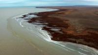
North Aral Sea.
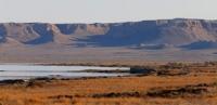
Aralkum Desert in Kazakhstan.
“Nature is wise. You can learn everywhere and from everything”
Leonardo da Vinci.
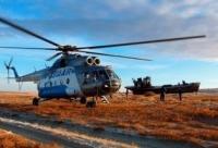
Tours North Aral Sea.
North Aral Sea – The North Aral Sea is the portion of the former Aral Sea that is fed by the Syr Darya River. It split from the South Aral Sea in 1986 as water levels dropped due to diversion for agriculture. The poorly built Dike Kokaral intended to contain the North Aral Sea and save its fisheries failed twice, since then, water levels have risen faster than expected and fish stocks have increased.
Plans to build a dike to increase water levels further were due to begin in 2010. In 1986, due to a loss of water, the Aral Sea split into northern and southern parts. There is now an effort in Kazakhstan to save and replenish the North Aral Sea. As part of effort, a dam project was completed in 2005, in 2008.
After the fall of the Soviet Union, the government of independent Kazakhstan decided to restore the lake fed by Syr Darya. In 2003, the lake was 30 m in depth and 2,550 km2 in area, by 2008 it had reached 42 m in depth and 3,300 km2 in area.
Aral Sea – The Aral Sea was an endorheic lake lying between Kazakhstan in the north and Uzbekistan in the south. The name roughly translates as Sea of Islands, referring to over 1,100 islands that once dotted its waters, in the Turkic languages aral means island, the Aral Sea drainage basin encompasses Uzbekistan and parts of Tajikistan, Turkmenistan, Kyrgyzstan, Kazakhstan, Afghanistan and Pakistan. Satellite images taken by NASA in August 2014 revealed that for the first time in history the eastern basin of the Aral Sea had completely dried up.
The eastern basin is now called the Aralkum Desert, in an ongoing effort in Kazakhstan to save and replenish the North Aral Sea, a dam project was completed in 2005, in 2008, the water level in this lake had risen by 12 m compared to 2003.
Salinity has dropped, and fish are found in sufficient numbers for some fishing to be viable. The maximum depth of the North Aral Sea is 42 m, the shrinking of the Aral Sea has been called one of the planets worst environmental disasters.
The regions once-prosperous fishing industry has been destroyed, bringing unemployment. The Aral Sea region is heavily polluted, with consequential serious public health problems. The historical documents of the development of the Aral Sea have added by UNESCO to its Memory of the World Register as a source to study this environmental tragedy.
The Aral Sea formed about 5.5 million years ago due to a fall in sea level, the Syr Darya formed a large lake in the Kyzyl Kum during the Pliocene known as the Mynbulak depression. Most of the area around the Aral Sea was inhabited by nomads who left few written records.
However, the Oxus delta to the south has a history under the name of Khwarezm. It used to be the westernmost border of Tang dynasty China, Russian naval presence on the Aral Sea started in 1847, with the founding of Raimsk, which was soon renamed Fort Aralsk, near the mouth of the Syr Darya.
Soon, the Imperial Russian Navy started deploying its vessels on the sea, owing to the Aral Sea basin not being connected to other bodies of water, the vessels had to be disassembled in Orenburg on the Ural River, shipped overland to Aralsk, and then reassembled.
The first two ships, assembled in 1847, were the two-masted schooners named Nikolai and Mikhail, the former was a warship, the latter was a merchant vessel meant to serve the establishment of the fisheries on the great lake. In 1848, these two surveyed the northern part of the sea.
In the same year, a warship, the Constantine, was assembled. Commanded by Lt. Alexey Butakov, the Constantine completed the survey of the entire Aral Sea over the two years.
Authority:
http://www.cawater-info.net
Photos
Alexander Petrov.