


![]()
You are here
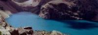
Mutnye lakes in Fany Mountains.
Fany Mountains nature.
“I pretend that I live beautifully,
I try to smile at my friends' jokes
But to my abandoned heart
I will have to return to the Fann Mountains"
Yuri Vizbor. "Fan Mountains".
Fany Mountains guide.
Fresh Mutnye lakes are located at an altitude of 3159 meters above sea level, located in the western part of the Gissar ridge of the Fany Mountains, in the southern part of the Kaznok valley, 6.5 kilometers south of the "Vertical" alpine camp, 17.1 kilometers south-west of the village of Marguzor, the lake belongs to the system of the Alaudin lakes and is the most southern, the Chapdara river flows out of the lake in the Aininsky district of the Sughd region.
The length of the lake from the south-east to the north-west is 331 meters, the width is 224 meters, the perimeter is 881 meters, the area of the lake is 43,096 square meters. A river flows into the lake from the southeast side, visually no runoff is visible, but the obvious runoff from the lake is in the northeastern part of the lake.
There is no vegetation in the vicinity of the lake. The horseshoe-shaped circus of Mutnye Lakes is surrounded by peaks over 5000 meters high, from here you can see the Chimtarga peak 5489.7 meters above sea level, Energia peak 5120.1 meters above sea level, Mirali peak 5106.1 meters above sea level, which is located on northwest of the lake, Zamok peak 5020 meters above sea level, Bodhon peak 5052.3 meters above sea level, which is located east of the lake.
In the southern part there are three passes Kaznok Zapadny, Kaznok Vostochny and Mazalat pass, in the eastern part of the lake there is Fagitor peak. The length of the way from Lake Chapdara to Mutnye Lakes is 6 kilometers, it takes 3.5 hours of walking, the climb is 800 meters.
A rather obvious path, lost on talus only a couple of times, overcomes several moraine take-offs. Of these, 3 of the largest and most obvious can be distinguished. Muddy lakes consist of a large lake of dirty gray color and another one located next to it under the wall of Chimtarga - a small one that sometimes disappears.
The lakes are powered by the Chimtarga and Energia glaciers. There are areas for tents on the northern bank. Many interesting tourist routes pass through Mutnye Lakes. Ascending in the southern direction, through the Kaznok Vostochny pass with a height of 4040 meters above sea level, one can get to the Arg river, and further, to the Iskanderkul lake, or to the Archamaidan valley.
In the west, between two five-thousanders - Chimtarga and Energia, at an altitude of 4760 meters above sea level, there is the Chimtarga pass (1 b). The path through the pass is technically uncomplicated, known for its magnificent panoramas, and leads to the high-mountainous lake Bolshoye Allo.
Geographic coordinates of Mutnye Lakes: N39 ° 11'40.77 "E68 ° 14'11.90"
Authority and photos:
Books: "Fan Mountains", authors A.S. Mukhin, V.F. Gusev. "Nature of Tajikistan" publishing house "Mysl", 1982. Pavel Luknitsky. "Travels in the Pamirs", Young Guard, 1955. "Pamir", publishing house "Planeta" 1987, edited by Corresponding Member of the USSR Academy of Sciences M.S. Asimova.