


![]()
You are here
Mountains Sandyk-Tau.
Sights Sandyk-Tau mountain.
“What is that feeling when you're driving away from people and they recede on the plain till you see their specks dispersing? - it's the too-huge world vaulting us, and it's good-bye. But we lean forward to the next crazy venture beneath the skies”
Jack Kerouac, «On the Road».
Trip from Kokshetau to of Astana.
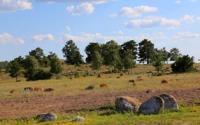
The granite mountains of Sandyk-Tau are located in the southern part of the Kokshetau Upland, in the west of the Zhaksytukty Mountains, in the southeast of the Zhylandy Mountains and in the south of the Zerenda Mountains, in the interfluve of Atyzhek and Zhylandy in the Sandyktau district of the Akmola region.
The Sandyk-Tau mountain range is divided into Southern and Northern. The southern Sandyk-Tau massif stretches from southwest to northeast for 34 kilometers. The dominant landmark of the Southern Massif is the Sandyk-Tau hill, 626 meters above sea level.
In the southwestern part, the peaks reach 490 meters above sea level, in the northeast up to 535 meters above sea level. In the southeastern part of the Southern Sandyk-Tau mountains there is Mount Sinyukha, 589 meters above sea level, and to the southwest of it rises an unnamed mountain with an elevation of 522 meters above sea level.
The northern Sandyk-Tau massif stretches south from Lake Kumdykol for 24 kilometers. The highest hill of Northern Sandyk-Tau is an unnamed peak 597 meters above sea level located in the central part of the massif.
4 kilometers east of the village of Sandyktau there is a hill with a height of 490 meters above sea level, another 6 kilometers to the east there is a mountain 512 meters above sea level. The mountains are located in a forest-steppe, resort area, where rocky hills, fields and mixed forests alternate.
There are picturesque reservoirs and springs here - Zinovyevka, Novonikolskoye, Militseisky spring, Lake Kumdykol. Main woody vegetation: pine and birch. The rivers – Kabany Klyuch, Atyzhok, Ushasha, Zhabai – originate in the mountains.
In the southwestern part of the mountain is the regional center of the Sandyktau region - the village of Balkashino.
Geographic coordinates of Sandyk-Tau mountains: N52°33'56.93" E68°55'48.90"
Note:
If you are using geographic coordinates for Google Earth or Google Maps navigation systems, you must remove the last two digits from geographic coordinates and " (hundredths of a second) and enter the result in the input line. Example: N51°44'09.67" E72°39'40.81" = N51°44'09 E72°39'40
Authority and photos by:
Alexander Petrov.