


![]()
You are here
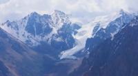
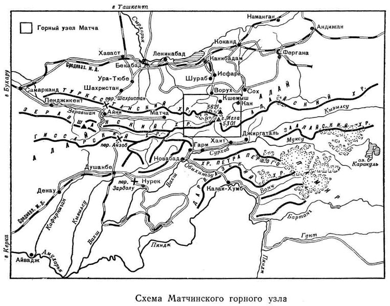
Mountain knot Matcha.
Small Group Hiking Trips in Uzbekistan.
“Not all those who wander are lost”
J.R.R. Tolkien.
Walking Routes Around Tashkent.
Mountain knot Matcha - this is how the Zeravshan knot of glaciation is often called in the immense mountain system of the Pamir-Alai, where at the 70 ° 40 'meridian the Alai ridge branches into Turkestan and Zeravshan.
All three ridges, stretching out in the latitudinal direction, have risen here to almost 4800 meters above sea level. Numerous peaks exceed 5000 meters above sea level. In the area of the junction of the Turkestan and Zeravshan ranges, there is a huge Zeravshan glacier, from which the Zeravshan River flows, in the upper course bearing the name of the Match.
The territory of the mountain node is vast. The area of its alpine part alone is about 10,000 square kilometers. Administratively, the Matchinsky mountain knot is part of Kyrgyzstan to the north of the Turkestan and Alai ranges, and Tajikistan to the south. In the northern part of the node, the basins of the Isfara and Sokh rivers belong to Tajikistan and Uzbekistan, respectively.
Natural conditions of the mountain node Matcha.
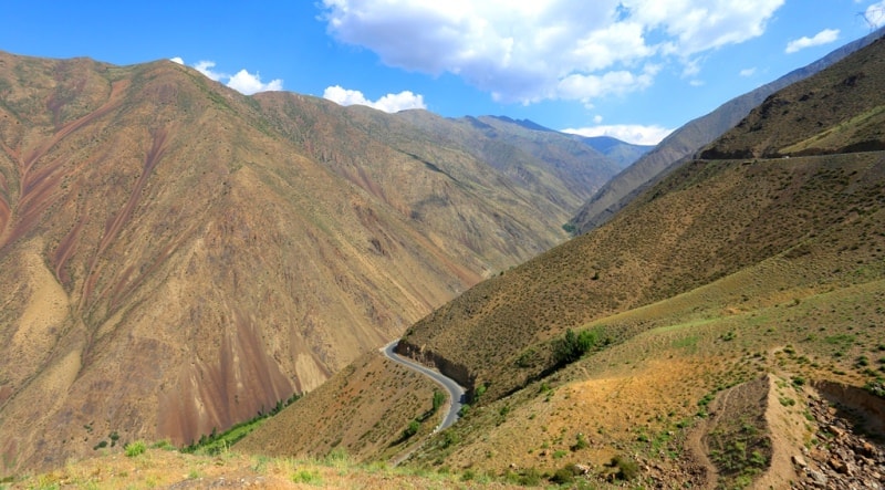
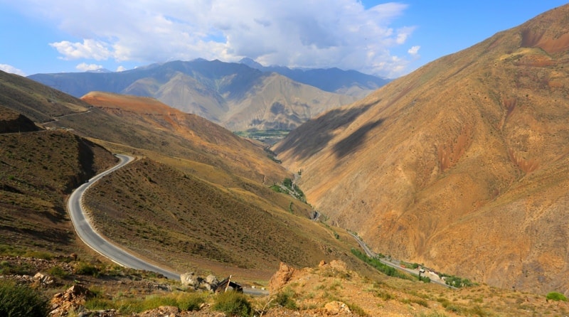
The mountains of the Matchinsky Knot are of the Alpine type. Having sharp and sharp outlines, they do not fall below 3500 meters above sea level over a considerable length, both in latitudinal and meridional directions.
Five-thousanders of the Turkestan, Zeravshan and Alai ridges are covered with glaciers and eternal snow. The entire mountainous region of the Matchinsky knot is an alternation of high ridges and deep, narrow intermountain valleys.
Schematically, the Matcha mountain knot has the shape of an oval with a powerful mountain uplift and extensive glaciation. In the center lies the Zeravshan glacier. From the north, the node is bounded by the high-mountain valley of the Karavshin River and the wide valley of the Isfara River, from the south by the valley of the Surkhob River, from the west by the upper reaches of the Zeravshan Valley, and from the east by the valley of the Sokh River and its sources.
However, if we draw a straight line from west to east through the Zeravshan glacier, the Matcha pass and the Ak-Terek river valley, then the whole node can be conditionally divided into two regions - northern and southern.
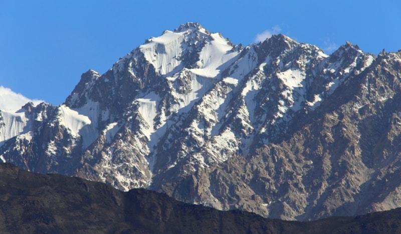
The basis of the northern mountainous region is the Turkestan ridge, which has an altitude of over 4000 meters above sea level for a considerable length. The highest peak is Pyramidalny Peak, 5510 meters above sea level.
To the east of the Turkestan ridge, at the same latitude, as if continuing it a little from the Kshemyshbashi peak, 5282 meters above sea level, the Ak-Terek massif is located with the highest point of the entire mountain node Matchapik Skalisty, 5621 meters above sea level.
Such peaks as Fighter, 5398 meters above sea level, Cliff 4900 meters above sea level, Minteke, 5482 meters above sea level, Granitniy peak, 5278 meters above sea level, and others are only slightly inferior to them.
The ridges and peaks of the Turkestan ridge lie in the zone of eternal snow, the border of which on the northern slope runs at an altitude of 3500-4000 meters above sea level, and on the southern one, due to the dry climate, it is slightly higher.
The ridge is composed mainly of siliceous and clayey shales, sandstones, limestones; in the eastern part there are marble, granite, and gabbro. The northern slope of the Turkestan ridge, facing the Fergana Valley, is longer and flatter than the southern one.
Tourists, going down it, can see here all the diversity of the nature of the mountains. Above, above 3500 meters above sea level, a rocky snowy desert dominates. Below is the alpine belt. Glaciers are concentrated on the northern slope of the ridge: Kshemysh, Shchurovsky, Minteke, Karatura, Tamyngen, Dzhaupaya, etc.
Almost all of them slide into deep gorges to the border of the forest. The rocky ridges separating them with five-thousanders are intricately decorated with hanging glaciers and snow-capped canyons. To the north, pointed peaks and sharp slope ridges give way to smoothed domes and soft, rounded ridges of foothills.
The southern slope, as opposed to the northern one, is steep, short, and strongly dissected. Between the rocky, almost sheer walls of the ridges, crowned with numerous tar and hanging glaciers, among the five-thousandth peaks there are glaciers: Mir-Amin, Skachkova, Tolstoy, Farakhnou, Rama, etc.
The surface of the glaciers, especially in the places of their confluence with the Zeravshan glacier, is covered with debris. Everywhere there are gray rocks and dull rubble. However, even here, among the wild and lifeless stones, there are strips of green lawns with bright alpine flowers and scattered juniper bushes.
The Ak-Terek mountain range is a huge rocky rise surrounded by several five-thousanders. In the center is Skalisty Peak, 5621 meters above sea level, crowned with numerous ice faults, hanging glaciers and icefalls that fan out along steep slopes in all directions.
In the west, the wall of the Ak-Terek massif drops abruptly towards the Kshemysh glacier and bears the Davgulevich glacier of a bizarre shape. The glaciation area of the entire northern mountainous region is significant.
Glaciers are evenly distributed, but still most of them are located on the northern and southern slopes of the Turkestan ridge. The region's glaciers and snowfields are fed by numerous rivers. Those that flow from the northern slope (Kshemysh, Dzhiptyk, Minteke, Karatura, Tamyngen, Dzhaupaya, Urtachashma and Karavshin) belong to the Isfara basin, and from the southern - the Zeravshan basin.
Their deep valleys dissect the northern slope of the huge Turkestan ridge into elongated the meridional direction of the spurs. Glaciers on the eastern and southern slopes of the Ak-Terek massif feed the basin of the Sokh River, and the western slope - the Kshemysh River.
Cutting through the side ridges and spurs, the rivers often form canyons with sheer walls up to several tens and even hundreds of meters high (for example, the canyons of the Sokh and Qalaimahmud rivers). Lakes make the region especially attractive, but the Matchinsky Knot is not rich in them.
The only large lake - Karakul-Katta - is located in the northern mountainous region in the Ak-Terek massif, at an altitude of almost 3200 meters above sea level. Three blue lakes, insignificant in size, are located 2 - 3 kilometers above the end of the Shchurovsky glacier, on its right bank.
The turquoise lake also took refuge at the foot of the Long-awaited glacier icefall. All four lakes are located at an altitude of about 3600 meters above sea level. The base of the southern mountainous region is formed by two ridges.
The first of them is Zeravshansky. From the junction of the Turkestan and Zeravshan ranges, or rather, from the southern slopes of Igla Peak, 5301 meters above sea level, it continues the Alai Range. For a considerable extent, both ridges are more than 4000 meters above sea level.
The highest point of the region is an unnamed peak, 5320 meters above sea level in the Alai ridge. The peaks are approaching this height: Belaya, 5000 meters above sea level, Akhun, 5223 meters above sea level, Head, 5004 meters above sea level, Snezhnaya, 4999 meters above sea level and others.
The Zeravshan Range at the junction (sometimes called the Matchinsky) is a narrow snow-covered mountain range with peaks reaching 5,000 meters above sea level or more. The ridge is composed mainly of limestone, sandstone and shale, in some places marble and magmatite occur.
Slates are especially characteristic of the northern slope, where they are associated with a wide distribution of rubble talus. The slopes of the ridge are not the same: the northern one is much flatter and wider than the southern one, which in places is often cut off by a sheer wall.
Both slopes are cut by deep, narrow gorges and canyons. The northern slope of the ridge bears significant glaciation. Glaciers Bely, Akhun, Nazar-Ailyak I and II, Paran, Yarkhich, Parak are left tributaries of the Zeravshan and carry a huge amount of snow.
The Zeravshan glacier begins near the Matcha pass at an altitude of 4200 meters above sea level, from where it descends in a huge tongue along the hollow between the Turkestan and Zeravshan ranges. Now its lowest parts are at an altitude of 2,775 meters above sea level, and once they were much lower.
The Alai Range is the most pointed and rocky. Its northern and southern slopes are heavily indented by narrow, deep gorges, where violent streams rush in cascades of waterfalls. On the northern slope of the ridge there are glaciers: Matcha, Igla, Ailanysh, Klyueva, North Tutek, North Yashilkul and Archabashi.
The snow zone here is located at an altitude of 3800 - 4000 meters above sea level. Glaciers are accompanied by high and sharp moraines. The Zeravshan and Alai ranges from the south form a kind of a single mountain ensemble.
Here, among the rocky, almost steep slopes of the gorges, glaciers deserve attention: Fiturak, Darapioz and South Tutek. The snow zone lies at an altitude of 4000 - 4200 meters above sea level. The glaciers and snowfields of the northern slope of the Zeravshan Range feed the Zeravshan basin, and the Alaysky one - the Sokh River basin. The rivers of the southern slopes of both ranges feed the Surkhoba basin.
The climate of the Matcha mountain knot is moderately continental, and in the foothill regions it is moderately warm. The abundance of the sun.
The average annual sunshine duration is 2500 - 2700 hours (in Moscow - about 1600 hours). Summer is hot, but without stuffiness. Winter in the mountains is cold, with frosts. One of the features of the climate is the uneven distribution of precipitation over the territory throughout the year.
In addition, they mostly fall out during the cold period, and in the warm period they are either absent or negligible. The westerliest and southwestern winds are the most humid, which, meeting high ridges on the way, gradually give them moisture.
The total amount of precipitation in the mountainous region is about 300 - 600 mm, most of it remains on the southern slopes of the mountains. So, in the Isfara oasis (the city of Isfara) about 130 mm of precipitation falls per year, to the west of Isfara, in Ura-Tyube, - 380 mm, and in the south, in the Surkhoba valley (Garm village), - 700 mm.
The frost-free period in the Match lasts from April to October, in Isfara - 203 days, in Ura-Tyube and in Garm - 195 days. It is convenient to divide the whole year in the region of the mountain node Matcha into two climatic periods: cold-humid (November - April) and warm-dry (May - October).
During these periods, the annual temperature fluctuations throughout the region are not great. So, the average temperature in Isfara in January is -2 °, in July + 25 °; in Ura-Tyube in January - 2.5 °, in July + 23 °; in Garm in January - 4.5 °, in July + 24 °.
The mountains, retarding the cold winds of Siberia in summer, make significant changes in the distribution of heat and precipitation. With a rise for every 100 m, the temperature drops by 0.6 - 0.7 °, and the amount of precipitation increases.
On the entire territory of the foothills, up to an altitude of 1500 meters above sea level, from May to October there is warm or hot weather with temperatures ranging from 10 to 30 °. From November to March it is cool, from 1 to 6 ° C.
The average precipitation is up to 350 mm. At the same time, in the mountains at an altitude of 3000 - 4000 m above sea level, it barely takes 2 - 3 months with temperatures above 10 - 15 °. Cool weather, winds, drizzling rains or snowfalls prevail there.
Precipitation falls up to 900 mm. In the Dzhiptyk valley, for example, at an altitude of 3100 meters above sea level, the average January temperature is 9.4 °. During the cold-humid period, frosts up to 30 ° are observed. In July it is warm (4 - 20.3 °), and the highest temperature for the warm-dry period of the year does not rise above + 25 °.
Autumn in the mountains is dry and warm. This is perhaps the most enjoyable time of the year for tourist travel. However, the mountainous relief can also affect the fact that in nearby places on the same day, weather conditions can vary greatly.
It is often warm and clear in the gorge, and the peaks of the neighboring mountains are shrouded in clouds, it is raining or snowing. Sometimes, high in the mountains, the weather changes several times a day. Depending on the height of the place and the nature of the relief, the climate of the Matchinsky mountain cluster can be divided into several types:
1) a climate with very hot summers and mild winters, tourists will meet on the access roads to the travel area (350 - 500 m); it is characterized by a long (more than 200 days) summer and little rainfall;
2) a climate with hot summers and cool winters is typical for foothills at altitudes from 500 to 1500 m and higher valleys; precipitation falls here 350-700 mm;
3) a temperate climate is typical for mountain ranges at an altitude of 1500-3000 m; there are cool summers and cold winters; there is a lot of precipitation in the autumn-winter-spring periods;
4) a cold climate prevails in the mountains at an altitude of more than 3000 m; the summer is very short there, and the winter is long and frosty.
Vegetation and fauna of the Matchinsky mountain knot.
The high mountains of the Matcha knot, standing in the way of moist winds and retaining moisture on the slopes, predetermined the diversity of the climate, and with it the originality of the development of mountain vegetation.
There is little rainfall in the desert areas that occupy the foothills of the mountains or high-lying closed highlands. The higher the mountains, the more precipitation, the richer and more diverse the vegetation. At altitudes from 300 - 500 to 700 - 800 meters there are deserts and semi-deserts.
Precipitation falls here from 175 to 350 mm. This is a transitional zone to mountain steppes. However, often in the highlands (up to 4500 meters above sea level), where there is little rainfall, you can find desert and semi-desert.
History and economics of the mountain knot Matcha.
The diverse nature of the territory of the Matcha knot, where the fertile lands of the valleys are combined with luxurious mountain pastures, largely determined the direction of the development of the economy - cattle breeding and agriculture.
In ancient times, when these areas were occupied only by nomadic tribes, hunting played an important role in their economy, especially with hunting birds (falcon, hawk, golden eagle) for foxes. With traps, snares, people hunted wild sheep, roe deer, goats, wolves, sometimes a bear and a leopard. Despite their nomadic lifestyle, they knew blacksmithing and jewelry.
They grinded and carved various dishes, musical instruments from wood. Felt was felted from wool, carpets and patterned fabrics were made, lassos, so necessary in the economy of nomads. Folk craftsmen, with manual painstaking labor, created everything needed in a nomadic semi-handicraft economy.
From about the 5th century A.D. e. a sedentary agricultural culture began to penetrate into the life of nomadic peoples. Blooming oases with complex irrigation structures were created along the valleys and in the foothills of the ridges surrounding them.
They sowed wheat and barley, planted gardens and vineyards. At the same time, cattle breeding developed - sheep, horses, camels and yaks were raised. Already in the X century, a high level of development of a sedentary agricultural culture was achieved.
At the end of the 19th century, the annexation of the peoples of Central Asia (Turkestan Territory) to Russia made its internal regions accessible for scientific research. A. P. Fedchenko, I. V. Mushketov, N. A. Severtsov, P. P. Semenov-Tyan-Shansky, N. M. Przhevalsky began to study these places for the first time.
The first attempt to penetrate deep into the mountainous part of Central Asia was made by A.P. Fedchenko. In 1868 he visited the Zeravshan valley, and in 1869 and 1871 - the Kuhistan mountainous area in the upper reaches of the Zeravshan and its tributaries.
In 1871, Fedchenko discovered a large glacier in the upper reaches of the Karavshin, which he later named after the famous Russian geologist and traveler G.E.Shchurovsky. In 1880, geologist I.V. Mushketov entered the Matcha mountain knot.
He was the first to pass the Zeravshan glacier from the Matcha pass and descended from it to the east into the Sokh valley. In 1906, the expedition of the German mountaineer Rikkmer-Rikkmers passed to the Matcha pass, first visited the upper part of the Zeravshan glacier, located upstream (downstream) of the Obriv peak, and gave the first description of its origins.
After the October Revolution and the establishment of Soviet power, the Turkestan Territory embarked on the path of socialist transformations. And of course, with the help of the materials of the first researchers, the secrets of the Pamir-Alai mountain knot with its huge ice spaces - hardened natural reservoirs that give rise to numerous rivers of the region, sources of life for fields, gardens and vineyards - were deciphered.
The young republics - Tajik, Kyrgyz, Uzbek - made progress in the economic, political and cultural development of their peoples. Industry and agriculture developed at a rapid pace. Nowadays, the main wealth of the region, where the Matchinsky high-mountain knot is located, is coal, oil, zinc, lead, tin and many other minerals.
Horticulture and viticulture occupy an important place in the economy of the region. Even in the distant past, Russian merchants drew attention to the amazing sweets Khojent apricots, dried apricots and uratyubinskiy raisins. The world market gave them high marks then.
In the lower zone of the Fergana Valley (Leninabad, Kanibadam, Isfara, Sokh), apricot orchards prevail, and above, in Ura-Tyube, there are grape plantations. The main fruit crop at present is apricot. Walnuts, almonds, peaches, apples, pears, cherry plums are also grown in the foothills and low-mountain areas.
The gardens here are the adornment of the valleys and local villages. Sericulture is one of the most industrial branches of agriculture in the region. In the pre-revolutionary period, all dekhkans (hereditary farmers) were engaged in it.
The women patiently carried a bag of corn (silkworm testicles) under their armpits, then fed the caterpillars with mulberry leaves for weeks in warm dwellings, until the cocoons were tied. Currently, there are factories for breeding grena, which is then revived in incubators, and the caterpillars are fed in special rooms.
The region is of great value to pastures in the mountains, used mainly for grazing sheep and cows brought here for the summer from different republics. In Soviet times, climbers and tourists began to explore the Matchinsky mountain knot.
The first steps of climbers were associated with the search for minerals. In 1934, V. Abalakov, V. Zeidler and V. Milyaev, as part of the Tajik-Pamir expedition of the Academy of Sciences of the USSR, climbed the wall on a steep slope of the peak in the region of the Turkestan ridge, to the tin deposit.
In 1935, climbers bypassed all the slopes of the basins of the Tamyngen and Rama glaciers in the Turkestan ridge, passed the Preobrazhensky and Farakhnou glaciers, helping geologists to explore new deposits of tin.
In 1940, the expedition of the Moscow House of Scientists, headed by V. Nemytsky, surveyed the regions of the Raygorodsky and Utren glaciers, visited the foot of Igla Peak, receiving a lot of valuable materials to clarify the map of the site and describe the glaciation of the area.
The next expedition to this area was organized in 1957 by tourists under the leadership of L. Vasiliev. It passed from north to south through the Turkestan ridge in the area of the Tamyngen-Rama (Razdarg) glaciers and further through the Zeravshan ridge to the Fan Mountains.
The most intensively began to develop the area of the mountain knot Matcha only in the 60s of the expedition of the Moscow Tourist Club under the leadership of Yu. Romanov, S. Weizman, D. Fomenko, M. Gantsevich, S. Alimov, I. Gergokov.
Authority:
L.A. Maximov "Matchinsky mountain knot". M., "Physical culture and sport", 1973.
Photos by
Alexander Petrov.