


![]()
You are here
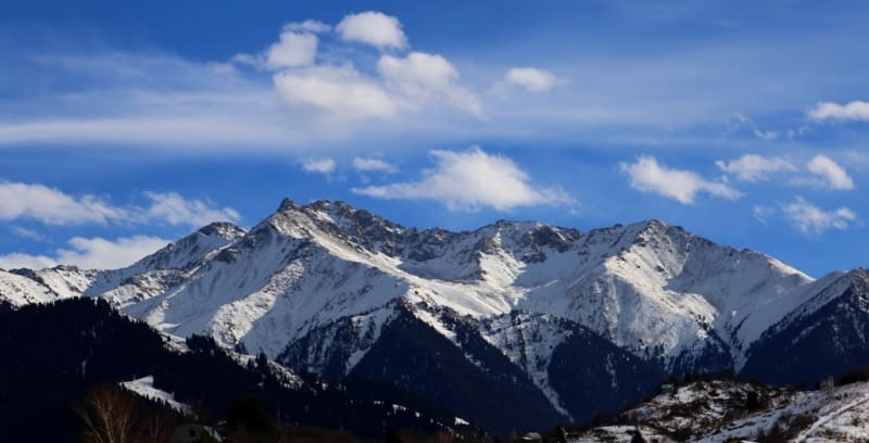
Mountain horseshoe Aksai. Zailiysky Alatau.

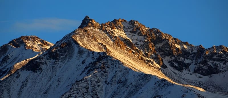
Climbing peaks in Zailiysky Alatau.
“Among the continuous snowy shroud, bare sheer cliffs protrude, like terrible ulcers. Millions of centuries of hostile inaccessibility gravitate over lonely peaks. If it were not for these white clothes, then what gloom, preserved from the primeval days of the earth, would have pressed from there from above on the valley lying at the foot. But the severity of grandeur was softened by boundless eternal beauty. An inexhaustible variety of forms, bold wild curves, and the inconsistency of content for a long time chain the poor thought of man. These are not tedious hours of everyday life, where a boring petty life is repeated with regular accuracy, but a powerful uplift of spirit, a dismissive indifference to what is too, too ordinary.
N. N. Palgov, In the Central Tien-Shan.
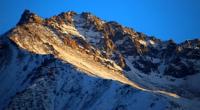
Peaks in Zailiysky Alatau.
Mountain horseshoe Aksai is located in the crest of the Kaskelan spur between the sources of the Kaskelen and Left Aksai rivers on the northern slope of the Zailiysky Alatau ridge in the Karasai district of the Almaty region.
Mountain Aksai horseshoe is a area between the Aksai and Kaskelen gorges. It is located 40 kilometers southwest of Almaty. The state border between the Kyrgyz Republic and the Republic of Kazakhstan runs along the Zailiysky Alatau ridge.
Here are the high-mountain passes of the ridge and the Kaskelen spur at an altitude of more than 4000 meters above sea level up to 2A category of difficulty. Glaciers form the mountain rivers Aksai and Kaskelen.
The length of the Aksai mountain horseshoe is about 11 kilometers. Aksai mountain horseshoe starts from the top of Ak-Ku with a height of 4074.5 meters above sea level. The Mountain horseshoe Aksai is located in the main ridge of the Zailiysky Alatau ridge at the headwaters of the Western branch of the Left Aksai glacier, 1.6 kilometers long.
Left Aksai glacier is divided into two branches - Eastern and Western. The glacier of the East branch of the Left Aksai, 1.3 kilometers long, surpasses the glacier of the Western branch of the Left Aksai in area. From the top of Ak-Ku, the Aksai horseshoe stretched west along the main rowing ridge for a distance of 2.2 kilometers to the top of Tur, 4350 meters above sea level.
From the top of the Tur, the horseshoe turns north and gradually passes into the powerful Kaskelen spur for 9 kilometers. The direction of the Kaskelen spur is sustained from south to north. Moving to the north, the spur separates the basins of the right source of the Kaskelen River and the western source of the Left Aksai River.
From the crest of the Kaskelen spur, the Makarevich glacier flows to the west to the sources of the right Kaskelen. Passing the Shnitnikov pass, the crest of the spur reaches the top of Gorbunov, 4023 meters above sea level. Soon the spur turns sharply to the west and forks.
At the fork, there is the Mir glacier, 1.5 kilometers long, which descends from the northern slope of the Gorbunov peak and flows around the mountain range, in which the Mir peak is located, 4085.5 meters high above sea level.
Its main branch stretches northward, passing the Mezhozerny Pass, the Pogranichnik Peak, 3,824 meters above sea level, and further through the Training Pass, 3,470 meters above sea level. The second branch also departs to the north, separating the western source of the Left Aksai from the eastern one.
In the book of V.I. Stepanova "Peaks of the Trans-Ili Alatau" is a description of the passage of the traverse of the Aksai horseshoe through 14 peaks.
First ascent of peaks of Aksai mountain horseshoe in Zailiysky Alatau.
1958.
In March, for the first time, the traverse of the Aksai horseshoe was made by a group of Alma-Ata climbers led by B.A. Studenina.
Geographical coordinates of Aksai mountain horseshoe in mountains of Trans-Ili Alatau: N42°59'02.40" E76°44'22.66"

Authority and photos by:
Alexander Petrov.