


![]()
You are here
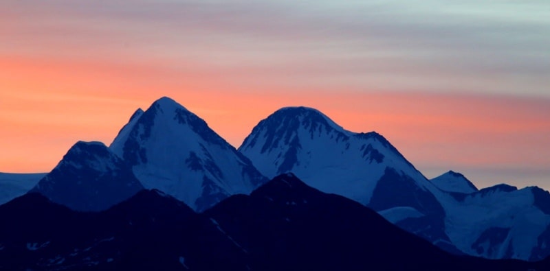
Mount of Belukha.


Climbing tours to mount Belukha.
“Climb the mountains and get their good tidings. Nature's peace will flow into you as sunshine flows into trees. The winds will blow their own freshness into you, and the storms their energy, while cares will drop away from you like the leaves of Autumn”
John Muir. «The Mountains of California».
Belukha peak Climbing, Hiking & Mountaineering.
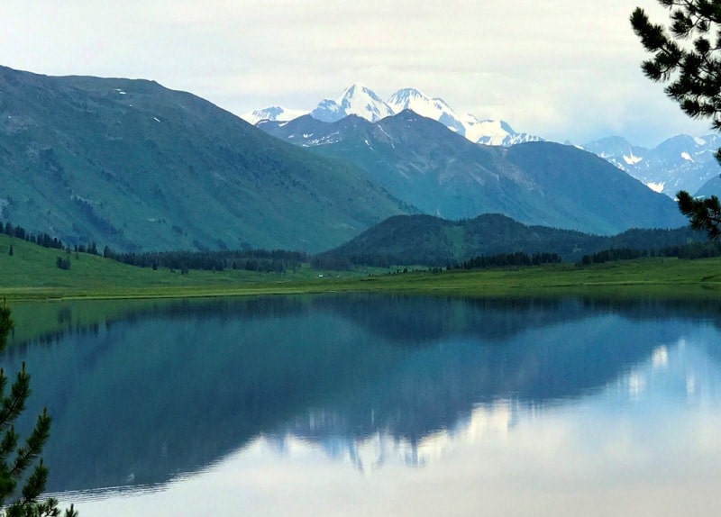
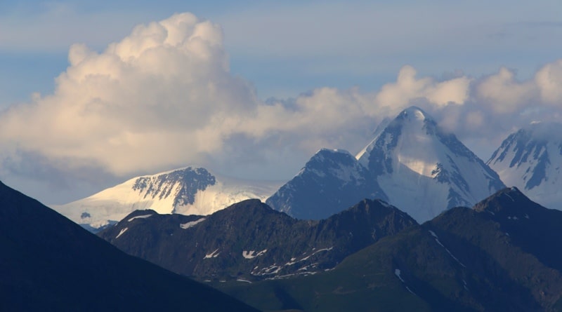
Mount Belukha is located in the central part, in the crest of the Katunsky ridge with a height of 4499.6 meters above sea level in the Katon-Karagay region, on the territory of the Katon-Karagay natural park in the east of the East Kazakhstan region.
Mount Belukha is represented by two more peaks in the form of irregular pyramids - Eastern Belukha 4070.3 meters above sea level and Western Belukha 4435.8 meters above sea level. The western slope of the Eastern Belukha ends almost vertically on the Akkemsky glacier, located on the territory of Russia.
The depression between the peaks, called the "Belukha Saddle" at a height of 4000 meters above sea level, also abruptly breaks off to the north to the Akkem glacier and forms the Akkem wall and descends more gently south to the sources of the Katun River.
The slopes of the summit are covered with eternal snow and glaciers over an area of about 70 square kilometers. From the southeastern slope of the Main Belukha peak, the Bolshoy Berelsky glacier descends to the Kazakhstani territory with a length of 6.4 kilometers.
From the northern slope of the summit, the glacier descends to the Upper Eastern Mensu Plateau and then flows down through the Berel saddle (Berel pass) down the Bolshaya Berel gorge. The Eastern and Western Belukha peaks are located on the territory of the Russian Federation.
The top of the Main Belukha is located 2.1 kilometers northeast of the peak of the Western Belukha. The summit of Eastern Belukha is located 1.2 kilometers northeast of the Main Belukha. The state border between the Republic of Kazakhstan and the Russian Federation passes through the peak of the Main Belukha. Popular rivers for rafting originate from the southern slopes of the Belukha massif: Katun, Berel. The Akkem, Argut and other rivers originate from the northern slopes. Belukha is an interesting object for mountaineering and mountain tourism.
History of first ascents to top of Belukha.
The first information about Mount Belukha dates back to the end of the XVIIIth century.
1836
The Belukha whale is being studied by the doctor of medicine F. Gebler, who undertook an eye measurement of its height. Gebler collected a collection of medicinal plants, discovered the Katun and Berel
laciers.
1904
Samuel Turner tried to climb Belukha in winter (early April).
1914
The first climbers, the Tronov brothers, made the first ascent of Belukha in the history of mountaineering.
July 20, 2000
The first paragliding flight from the Eastern Belukha at 4070.3 meters above sea level was made by Igor Levkin and Ivan Usanov.
2003
In August, Dmitry Shchitov made an extreme skiing from 4502 meters above sea level, the descent lasted about two hours.
Mysticism and legends about Mount Belukha.
Here, according to Buddhist legends, the legendary transcendental country of the gods of Shambhala was located and from here the great Buddha - Gautama came to India. The famous philosopher, artist, writer Nikolai Konstantinovich Roerich visited these places at the beginning of our century, studying the roots of Buddhism.
According to other beliefs, an energy bridge connects Belukha with Everest. Scientific, cultural and practical value: Mount Belukha, like a powerful magnet, annually attracts thousands of tourists. These are climbers striving to reach its peaks, and mountain tourists traveling within its limits, and rafters rushing along the Katun, Berel and Bukhtarma, and followers.
The beluga whale has long been shrouded in a halo of myths, secrets, and legends. Many believe that somewhere there is hidden the mysterious Shambhala, a paradise that will come after the disappearance of people.
Umai, the goddess of the Turks, lives on Belukha. From here the great Buddha - Gautama came to India. The Old Believers believe that somewhere nearby is the happy country of Belovodie, which not everyone can get into.
According to other beliefs, there is an energy bridge from Belukha right to Everest. Here is the center of the Earth, energetically connected with the Cosmos. Indigenous Altaians do not come close to their shrine. In Russia, in Altai, Belukha is called Uch-Syure, or Uch-Orion. Sure means the dwelling place of the gods. Uch in Turkic - "three".
Thus, Mount Belukha means "three dwellings of the gods", or "the dwelling of three gods", and the name Uch-Orion is associated with the three stars of the "belt" - the constellation of Orion. Therefore, the three-peaked Belukha has something to do with this constellation, and more specifically, with Orion's belt.
In the book of ancient Eastern legends "Cryptograms of the East" there is a legend about a holy stone that appeared from heaven as a "messenger" of distant worlds, as a gift from Orion. The legends indicate three specific stars that sent the stone to the world.
These three stars are the stars of the Orion belt, which were previously called, as N.K. Roerich writes, "Three Magicians". The ancient Altai name for Orion's belt is "Three Maralukhs", or Yuch-Myygok.
Glaciers of Belukha massif.
On the slopes of the Belukha massif and in the valleys, 169 glaciers are known, with a total area of 150 square kilometers, Mount Belukha bears almost 50% of the glaciers of the Katunsky ridge, which is over 60% of its glaciation area.
By the number of glaciers and glaciation, Belukha takes first place on the Katunsky ridge. M. V. Tronov singled out the Belukhinsky glacier region as an independent “type of Belukha glaciers”. It is characterized by: the high position of the feeding basins, the steepness of the firn streams, the low position of the tongues of glaciers that fill the bed of deep river valleys, and the tight junction with the slopes of the peaks.
6 large glaciers are concentrated here, among them the Sapozhnikov glacier - one of the largest in Altai - 10.5 kilometers long, with an area of 13.2 square kilometers, as well as the Big and Small Berel glaciers, 10 and 8 kilometers long and with an area of 12.5 and 8.9 square kilometers, respectively.
Geology of Belukha massif.
The Belukha mountain range is composed of Middle and Upper Cambrian rocks. Many spurs of the massif are outcrops of sandstones and shales. Less common are conglomerates. Part of the massif is composed of typical flysch-like formations.
Faults, cracks and thrusts of rocks testify to the tectonic instability of the territory of Belukha. Steep, almost sheer slip zones are characteristic of the northern slope of Belukha, especially from the side of the Akkem river valley. Large areas of the massif are occupied by rocks, talus and moraines.
The slopes are subject to the destructive effects of mudflows and avalanches. Belukha is a museum of a wide variety of geomorphological processes and landforms. The Belukha region is located on the border of zones of 7 - 8 magnitude seismic activity. Earthquakes are very frequent here.
Their consequences are the breaking of the ice shell, the descent of avalanches and landslides. Since the Paleogene, the territory has experienced intense tectonic uplift, which continues to this day.
Geographical coordinates of Belukha Peak Main: N49°48'29.62" E86°35'24.05"
Geographical coordinates of Belukha West: N49°47'48.79" E86°33'56.76"
Geographical coordinates of Belukha Eastern peak: N49°49'03.27" E86°35'56.88"

Authority:
Books: "Nature of Zailiysky Ala-Tau", M. Zh. Zhandayev, prod. Kazakhstan, Alma-Ata, 1978 "Across Northern Tien Shan", V. N. Vukolov, Moscow, Profizdat, 1991. Pozdeev-Bashta A. Mountain tracks of Almaty. - 2nd prod. - Almaty, 1998. Pospelov E. M. To the tourist about place names. - M, 1988. A. P. humpbacks. Mountains of Central Asia. Explanatory dictionary of place names and terms". - Almaty, 2006. Murzayev E. M. Geography in names. - M, 1982.
Photos by
Alexander Petrov.