


![]()
You are here
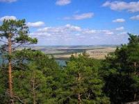
Mount Akdym in Yereymentau mountains.
Beautiful nature in Kazakhstan.
“We walked through the mountains of Zhamanniyaz. We walked in the same direction to the northeast to the Zhaksogniyaz valley. The position of the place is flat, with a birch forest, and then went to the tract Kyzylagash at Mount Chermentau (Yereimentau). The campaign was 20 miles. We walked 15 miles to the river Olenta, which brings its beginning from Mount Seyten. In this place was the Baibura-Karakisek volost ”...
Ataman Telyatnikov. 1797.
Kazakhstan and Astana vacation Packages Tours.
Mount Akdym, 901 meters above sea level, is located in the eastern part of the Yereymentau Mountains, on the territory of the Belodymovsky branch of the Buyratau National Natural Park, 8.7 kilometers west and slightly south of the village of Belodymovka, 16.6 kilometers northeast of the village of Kunshalgan, 35.5 kilometers southeast of the village of Olzhabay Batyr is located on the territory of the Osakarovskiy district in the northern part of the Karaganda region.
The northernmost point of the district and the entire region is Mount Akdym 901 meters above sea level in the system of the steppe ridge Yereymentau located in the Osakarovsky district of the Karaganda region. These places are noteworthy in many ways. Nearby, near the Olenta River, the borders of three regions converge: Karaganda, Pavlodar and Akmola.
The picturesque mountains of Yereymentau have long attracted travelers and scientists. In July 1797, Ataman Telyatnikov wrote in a camping diary: “We walked through the mountains of Zhamanniyaz. We walked in the same direction to the northeast to the Zhaksogniyaz valley.
The position of the place is flat, with a birch forest, and then went to the tract Kyzylagash at Mount Chermentau (Yereimentau). The campaign was 20 miles. We walked 15 miles to the river Olenta, which brings its beginning from Mount Seyten. In this place was the Baibura-Karakisek volost ”...
The names of the localities here are peculiar. Yereymentau has several options. Here is the easiest one. There is a proper name Ereimen, which is why Ereimentau means "the mountains of Ereimen", named after the person who once lived here.
The second interpretation of "Er" - in Kazakh, "saddle", "Emen" - "oak." The combination of the two words gives the "saddle of the oak fortress." According to the stories of local people, yereymentau birch is notable for its unusual strength, solid as an oak.
Kazakh craftsmen have long used rhizomes of birch for the manufacture of the wooden part of the saddle – “lenchik”. The mountains of Yereymentau have their own legend associated with the struggle against the Dzungarian invaders.
Batyr Bogum-Bai once drove the enemy into these mountains. In one of the gorges, the martial arts of Bogumbai with the leader of the Dzungars took place. The alien was defeated. Warriors of Bogumbai rushed to catch the horse of the enemy. Soon in the mountains jubilant cries rang out:
- Ermen, Ermen! With a saddle, with a saddle! Since then, the people began to call these mountains Yereymentau.
E. Koygubaev believes that the name comes from the Turkic-Mongolian word formation: "Areiman" - "small mountains". The translation of the word Akdym is also interesting. Two words came together here: Kazakh “ak” - “white” and Russian “smoke”.
In fact, the beginning comes from Akda "the whitening mountain." The letter “m” was added about 70 years ago by immigrants from Russia. Currently in the Yereymentau mountains are two reserves: Yereymentau (Akmola region) and Belodymovsky (Karaganda region).
Moreover, the Belodymovskaya forest cottage is part of the Yereymentau Nature Reserve. It crosses it from east to west, forming a territory of 15 kilometers length and 5 width. The area of Belodymovskaya forest dacha is 7500 hectares, including about 350 hectares are located on the territory of the Osakarovsky state farm.
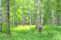
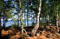
In the Yereymentau mountains, the vegetation complex of mountains and steppes, represented by individual birch and aspen forests, has been preserved. Some plants are peculiar relics of ancient communities. They especially need protection and research.
The most valuable plant in this list is sticky alder. It is listed in the Red Book of Kazakhstan. The tree reaches 20 meters in height, has red-brown young branches. The color of the old shoots is dark brown. Alder occupies the banks of streams, spring tracts.
Grows in a community with ferns. Small forests in the mountains of Yereymentau are the only ones in our region. Korzhinsky licorice plantations are concentrated here in the meadows and forest edges. This is a perennial herb with stems 40 to 70 centimeters high.
It is included in the "Rare and Endangered Species of Kazakhstan Flora in Need of Protection." In total, a rich and valuable gene pool of vascular plants in the amount of four hundred species has been preserved in the Yereymentau mountains.
Of these, 50 plants are of great interest to humans in food, medicine, fodder, decorative and scientific relations. On the territory of the Yereymentau small hills, not only flora, but also fauna are reserved. Representatives of mountains, steppes and forests have been preserved here.
There are argali, roe deer, fox, badgers, and groundhogs. Of birds, belladonna, black grouse, gray and white partridge. The greatest attention is paid to the archar recorded in the Red Books of Kazakhstan. Almost all year round argali live near Mount Akdym (899 meters above sea level).
There are steep and deep gorges. In spring and summer, argali annually go down to feed on their bottoms. Tentatively, it can be said that in the summer, up to 50 argali individuals live on the territory of the Belodymovsky Zoological Reserve.
To preserve these places of fabulous beauty, the Council of Ministers of Kazakhstan announced on December 7, 1971 the creation of the Belodymovsky Zoological Reserve. But scientists are now raising new challenges. In the mountains of Yereymentau a reserve is needed.
Only its creation will ensure stable environmental development of the environment. It is noted with concern that populations of rare plants are declining, as a result of livestock grazing young grass is dying.
Geographic coordinates of Mount Akdym: N51°12'58.99" E73°17'16.77"
Authority:
Yu. Popov, local historian. Labor banner. Youth, Feb. 1986, p. 4