


![]()
You are here
Landscapes of Charyn Canyon.
Walk to Charyn canyon.
“Nature has no principles. She makes no distinction between good and evil”
Anatole France.
Botanical tours to Charyn Canyon Kazakhstan
Valley of Castles in the northeastern tip of the Toraigyr Mountains, located at an altitude of 1112 to 910.9 meters above sea level, is located on the left bank of the river of the same name, on the territory of the Sharyn Natural Park, in the Uigur district of the Almaty region.
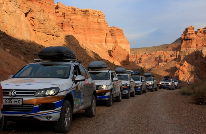
We come nearer to the ultimate goal of our travel. The road goes forward to settlements of Kegen and Zhalanash and leads to the eastern coast of the Issyk Kul lake. We have passed 190 km (these are 2/3 ways up to the Kirghizi lake).
But we, being guided by the road sign, turn before a ridge to the left to the earth road. The next 10 kilometer are a part of the way reminding a washing board, will lead us to the well-known "the Valley of castles». It seems, that here often caterpillar transport passes; however it's a wind, water and wheels that created "a comb" on the road.
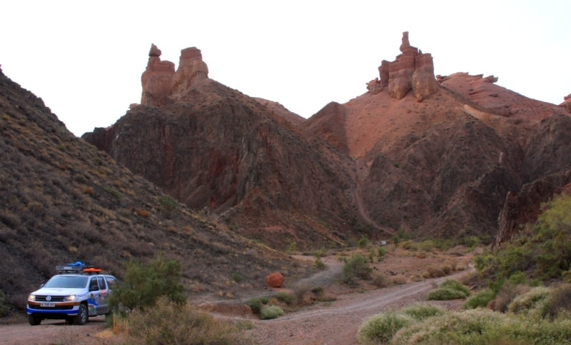
Approximately in 8,5 km an ecological post is situated where they will ask you to pay the amount equals to 3 - 4 dollars and after 500m there is a parking. To drive into «the Valley of castles» by a car is not a good idea.
First, rain streams and thawed snow make a slope a scour as the road was laid without engineering study and passes through a relief formed by the friable rocks. Secondly, it is absurd, having passed 200 km from Almaty to drive 3 km on a ravine bottom, missing the possibility to admire the surroundings.
The parking lot is marked with a sign, as well as two foot descents to the "Valley". The first one is just opposite the parking, the second one is 1 km to the north if you follow along the precipice. Distinction is that if you take the first descent, you will not be able to see a grandiose panorama of the whole natural complex, but immediately you find yourself surrounded by the clay rocks. Though the second descent is steeper, more dangerous and longer, a view opening from the top point compensates its inconveniences.
As shown in the scheme, on a bottom of the Valley it is necessary to go down to the Sharyn river bank. Here it is possible to find a place for rest at the bank and in an equipped roofed arbor ; to use it you should pay some rent to the local timber enterprise. In summer time a tent camp and a ferry on the right coast of the river is organized. If you take fishing tackles you will not be disappointed because each 5-6 minutes on your earthworm or corn you get the naked osman.
Especially it is necessary to remember the safety rules for to stay safe not only on the water (speed of its current up to 15 km per hour, depth up to 2 - 3 meters), but also in clay rocks. In no case it is allowed to climb the paths, traced by animals or scours. Slopes are not only steep , but also exposed to taluses and landslides!
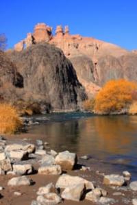
In front of us is the Red canyon (place name) or the Valley of castles, It is the most unique object of the nature where under influence of thousand-year processes of aeration of sedimentary rocks the original forms of a relief took shapes of the isolated rocks, columns, towers.
Experts name the destructive power of the wind, water and gravitation as an architect of this masterpiece. The word "canyon" in translation from Spanish means "pipe". The canyon is formed in dry plateaus where the river strongly deeps its bottom. Strictly speaking, the Valley of castles is a dry gorge washed out by thawed snow and settling down perpendicularly to the Sharyn river, punched for itself a way through the soft mountains and unapproachable stone rocks.
The length of the Red canyon is about 3 km, width from 20 up to 130 m, depth up to 100 m. It involuntarily this creation of nature can be compared with "The Grand canyon " on the Colorado river in Northern America. Landscapes have external similarity, but the canyon in Northern America has length of 800 km., at depth from 1200 up to 1800 m.
Philologists interpret a word Sharyn differently. In Turkic languages shar or zhar mean a precipice. And, really, here precipices are everywhere. Some people try to explain the meaning based on the Uigur word sharyn which means "ash" as the well-known ashen grove is located on banks of the river.
Ways to novel areas of the Central Asia attracted the well-known Russian travelers N.Severtsev, A.N.Krasnov, S. Valikhanov here. Certainly, they were attracted by this crack in the steppes as some kind of the lost world by which is impossible just to pass by.
The origin of canyons still causes many questions. Some researchers say, that all this district was a bottom of a shallow gulf of the sea, which covered the center of the ancient Asia from the coast of the today Alakol lake area up to the contemporary China territory. Sponges, sea hedgehogs, shells were found us in fossilized green clay so dead and passionless, so it is difficult to imagine them bathing once upon a time in greenish thickness of cool water, greedily catching the weak sun beams shining to the bottom.
All these creatures during antediluvian times crept on the sea bottom, hunted each other and bred. But time didn't spare the sea. The gulf gradually slowly disappeared, whether it turned to lake which in one bad day broke through the dam and fell into a cropper in the scour with all its inhabitants.
Professor PI.Marikovsky the author of the book "Sharyn's Destiny" confirms this version:" A long time ago, about 25 million years ago, during the tertiary period, when there were no people on the earth, here where now the wide hot desert is, a big lake rustled with its waves.
Surrounded by the mountains, it gradually destroyed them, forming at the bottom the powerful layers of clay mixed with fine rubble and a pebble. Then the climate changed, the lake disappeared, and its bottom was gradually washed away with water. That's how the country of naked lifeless and very strange clay mountains was formed".
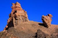
If we look closer at the "Castles" we shall find out, that the magnificent thin graphic paintings on their walls were created by alternation of the layers differing on color, granularity and stability to aeration. For a geologist these layers are the pages of the stone annals telling about pulsing processes of the Tian-Shan destruction. The layers are combined by huge boulders which are results of formation and destruction of the mountains. During the periods of short-term tectonic respites white limy layers were generated.
They play an important role in the rocks' architecture. They usually form flat "roofs" of the stone constructions, and sometimes hang in a form of the impressive consoles. If there were no stone strip of these exclusively strong rocks, there could be no steep walls and, thus no the Valleys of castles. Many figures have already been named: "the Dragon", "the Gorge of lions ", "the Valley of yurts ", "the Stone bag "... To bypass all labyrinths of the basic canyon and its inflows some days are needed. People who came here even once, fall in love with the Sharyn.
The legend says: " In the middle of the extended Zhalanash valleys the almighty God, passing on a chariot, dropped one of the fiery arrows. When fallen to the ground, the arrow split it into two parts, showing the nerves and veins running in the earth's depths". Really, made the terrestrial cleft, unknown forces slightly opened the very depth of the time. The huge crack, which stretched to the north, is lost on the horizon, impressing by the volume of works performed.
Let us pass the same way. In the Valley of castles the flora is rather poor because there is no soil cover. At the bottom there are bushes of a yellow acacia, a tamarisk, a saxaul with leafs as troad, an ephedra. Among them it is efficient fuss Agama lizards, buzz German wasps, crack cicadas. You can be surprised with the shells of the bullets shot into the ground.
They are signs of barbarous intervention of poachers. But, fortunately, in silent days when there are no tourists in the "Valley", you can easily find a colony of mountain partridges, frighten off a hare, and, having heard sounds of a rock falling have time to see the escaping mountain ram..
But the special delight is caused by the prompt flight of a falcon-baloban; one of five kinds of falcons in Kazakhstan. All falcons are birds of a dense constitution and of average size. They have a strong beak bent on the end. All of them are predators and possesses an excellent sight ( 8 times sharper a human sight).. They breed once a year and are also monogamous. Certainly they are useful, as hunting they exterminates, first of all, old and sick individuals. The main thing attracting humans to these birds is knack for hunting.
The falconry appeared about 2,5 thousand years ago in the East and through Russia reached the countries of the Western Europe. Hunting with birds, whether it is a golden eagle or a falcon is very popular. In steppe such hunting since ancient days has considered as one of the favorite kinds of sports and way of entertainment of authorities. For a long time it been a symbol and an attribute of the status and a wellness. Is not occasional that the price of one bird equals to several camels. Now it is up to 30 thousand US dollars.
For the Kazakhs a hunting bird is more, than simply a hunting bird. The Kazakh name this bird "itelgi" (it means a dog)as falcon knows well who is its master, can find him in any clothes, in a crowd, after long separation. Baloban is a large falcon. Its length is up to 60 sm., weight reaches 1200 gr., wingspan more than one meter. Its main weapon is a beak and claws. In mountains it nests on the precipices, in woods and in forest-steppes - on trees.
It borrows the thrown nest or expels the owner from it. The egg laying of a falcon consists of 5 - 6 eggs of red color. Hatching lasts for about one month, nestlings appear in the end of spring. Parents feed the nestling about 20 times a day. It quickly grows and by the end of June it already flies well and also hunts. In 2 - 3 years old they create their families.
Having passed on the valley bottom for nearby 3km, we came to the river bank. After exhausting heat of the Valley of castles, this place presents an oasis among a waterless desert. Sharyn is the basic inflow of the river Ile. The upper Sharyn is named the Shalkydusu and begins on the southern slope of the Ketmen ridge at height of more than 3000 meters.
After a confluence of the left inflow of the Karkary river, the water stream gets a name of the Sharyn. Width of the river is 30 - 40 m, length is 427 km, the area of pool is over 8000 sq. km. The river is fed by snow and underground water. The gudgeon and the naked osman are found in the river Sharyn. Its water is used for an irrigation of fields of the Uigur district.
At the head river there is a place for rafting. The water route along Sharyn is one of the most complicated in Kazakhstan. It for the first time it was passed in 1969 by Almaty tourists. They rafted by rafts, catamarans, inflatable boats and kayaks. Here are 13 rapids of a different complexity. Each of them has its own name as "First-born", "Tap dancing" , "Snake", «Three brothers». The most complex is "Albatross". The rafting on the Sharyn makes indelible impression.
The river accepts a number of the inflows and, becoming the deep river, cuts east parts of the Zhalanash hollow and the Torajgyr mountains by the grandiose canyon representing a deep river valley with almost steep slopes and rather narrow bottom, quite often completely borrowed by the river channel. At crossing the mountains Kuluktau and Torajgyr the river forms a canyon with depth up to 300 m., length of 100 km. On the Zhalanash plain it decreases up to 100 - 150 m.
The complex of Quaternary adjournment is opened by the Sharyn river. On the right slope of the river it is presented by the correct alternation of layers of yellow clay and weak cemented a sand- pebbles conglomerate. A sand ball to a sand ball and a molecule to a molecule of lime, conglomerated together under the pressure of the top layers and action of the various chemical compounds dissolved in water.
Due to the geological criterion the canyon is young. After the rise of the block of the earth s crust which happened in the foothills of the Tian-Shan, the river began to cut a pass for its. The gorge reached its present shape approximately half million years ago. The work of water continued the sun and water. This invisible skilful sculptor - the union of time and the nature- does not stop for a second to have a rest and a look on its mysterious and stately creations.
In 1886 a well known florist and geographer, the author of the first Russian university textbook " The Basis of physical geography" A.N.Krasnov visited these places. He wrote: "Coming to the Sharyn canyon, you find yourself in the steppe which is extensive and flat as a table. Far around there're blue mountains.
The ground breaks under your feet like a wall and forms multi meters precipice. Above it there's a highland of peaks, valleys and gorges . The country is severe and gloomy, abruptly allying in the deepest valley where the Sharyn roars, from this height it seems a narrow ribbon, framed with trees which crones are not bigger than a pea".
Inside of the canyon, where the Sharyn river flows, the original climate prevails since the ancient times. Here plants and animals found shelter which can't be seen anywhere else, for example, a relic sogdian ash-tree and a fish named "the naked osman".
There is also a turanga (a poplar), possessing valuable physiological qualities, stability to salt and dryness of air. It is an original tree with the bent trunk (and sometimes multitrunked) 20 and more meters high. It has a gray, wrinkled bark and a sprawling rather thin crone. The prominent feature is that form and size of leaves strongly vary, they can be narrow and long, oval or round. Presence of different leaves is caused by age variability. Leaves are dove-green, rough, dense.
Leaves and young branches never wither, but they have ability for self-regulation: if the air temperature grows up, they fall down, thus reducing the water consumption. Turanga groves can be met on different sites of the river bank. It can "cry with salty tears» from in the amazed places which flow down the trunk. It is a valuable tree for gardening in a deserted zone.
The most magnificent blossoms of the deserted vegetation are found in tugai-woods: impassable thickets of oleaster, willow, turanga, barberry, lomonos liana and high grasses. In the spring tugai (a bank wood) are full with various sounds of nature. There are grey titmouse, hawk sylvia, red and grey rubbish birds and wild pigeons in tugai. Disturbing clatter of pheasants is distributed in the mornings in reed thickets. They rise from the very feet with shout and noise so suddenly, that you may even shudder.
These are the brightest, beautiful birds of our wild chicken. However, only males are brightly painted. The females have modest grey feathers and when it sits in the bushes, its plumage merges so with the ground that it's very difficult to differ. Only females are deducing of posterity, thus they need protective color of feathers.
Huge birds are seen here and there on shallows of the river. Sometimes they sit directly on water, on a fine place, where a sandy spit departs from coast nearly up to the middle of the river, hardly covered by water. It is a white tailed eagle, now a rare bird. On the Ile banks it deduces nestlings and lives settled.
The mighty predator makes a nest somewhere at the top of a tree near to the river. But it is not a danger to small beasts and birds of local thickets and steppes: here the eagle eats fish only. Like a seagull it rushes into the water and suffices fish of any size. Its catch instrument is its claws.
Other animals live in tugai. In the evening you can see, how the water rat quickly floats on water to hummocks. It is easy to notice how it gets out on a hummock where it has a nest of the dry leaves. Wild cats run through the tunnels punched by wild boars, like a silent shadow and danger for birds and small beasts.
Our generation remembers another cats representative - the turan tiger who was completely destroyed by 1947 year. These tugai-woods are children of the deserted rivers. The wood perishes if the level of subsoil waters goes down or floods of the rivers we remember words of writer Gerald Darrel: "And still the majority of people do not realize how we ruin the world we live in. We behave as small silly children remained without supervision in a matchless amazing garden and transforming it in fruitless desert by means of poisons, sickles and fire-arms.
Quite probably, that within the last week's one more animal, bird or plant disappeared from the surface of the Earth. I hope, that it is not so, but I precisely know, that someone's days are counted down. Our world is so combined and vulnerable as a web. Touch a web, and the rest ones will tremble. And we not only touch webs, we leave huge gapping holes, we fight a biological war against the environment. Without need we reduce woods, we create the centers of dusty storms and wind erosion, thus changing the climate.
We litter the rivers with industrial wastes; we pollute the seas and the atmosphere. With our short-sightedness, avidity and nonsense we become originators of the sequences when it will become impossible to live on the Earth".
It worth to remember these words and we should live in harmony with nature. In fact owing to its generosity, having passed our routes, we could admire infinite circuits of mountain ridges, steep slopes of gorges, the high dark blue sky, yellow deserts, rough rivers and quiet lakes of unique natural complex of the Zhetysu.
Geographical coordinates of Valley of Castles in Toraygyr mountains: N43°21'11.47" E79°04'00.41"
Information is given and developed
By the deserved worker of tourism of Republic Kazakhstan, The candidate of pedagogical sciences, the guide - methodologist Lyuterovich Oleg Grigorevich.
Alexander Petrov by
photos.