


![]()
You are here
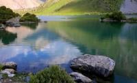
Lake Maly Kulikalon.
Guided walking tour to Kulikalon lake.
“Why are you standing on the path, why don't you want to go?
We need to finish the song, we need to be less sad.
Trains are screaming from below, but March ends
An early star rises, somewhere the avalanches are rustling"
Yuri Vizbor. "Dombai Waltz". 1961.
Landscape monuments of Tajikistan.
The fresh, flowing lake Maly Kulikalon is located at an altitude of 2837 meters above sea level in the intermountain Kulikalon depression, 367 meters east of Lake Kulikolon, east of the Govkhon mountains, northeast of the Saryob mountains, in the southern part of the Chimtarga valley, in the valley the Artuch river, 4.1 kilometers southeast of the Artuch alpine camp in the Fan Mountains, in the northern part of the Hissar ridge in the Penjikent region of the Sughd region.
The length of Lake Maly Kulikalon from south to north is 134 meters, the greatest width in the central part of the lake is 51 meters. The perimeter of the lake is 400 meters. The lake will be connected by a channel with Lake Lesnoy in the northeast and Lake Kulikalon in the southwest.
A juniper forest grows around the lake.
Geographic coordinates of Lake Maly Kulikalon: N39 ° 15'24.47 "E68 ° 10'44.17"
Authority and photos by
Alexander Petrov.