


![]()
You are here
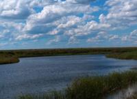
Lake Kokai in Korgalzhyn Reserve.
Trips to lakes of Korgalzhyn Reserve.
“A person who travels a lot is like a stone carried by water for many hundreds of miles: its roughness is smoothed out, and everything in it takes on soft, rounded shapes.”
Best routes in Korgalzhyn Reserve.
Lake Kokai is located at an altitude of 308.6 meters above sea level, located in north of the Kazakh small hills, at bottom of Tengiz-Korgalzhyn depression, on territory of Korgalzhyn natural park, in Korgalyzh district in southwest of Akmola region.
Lake Kokai is part of the Tengiz-Korgalzhyn lakes system. The area of Lake Kokai is 29.03 square kilometers. The length of the lake's coastline reaches 26.25 kilometers. The length of Lake Kokai is 8.7 kilometers, the greatest width in the southern part is 6 kilometers.
The northern part of the lake is located among the fixed, earthen coastal surface, while the southern part of the lake is located in the swampy part of Lake Korgalzhyn. The lake is located between lakes Sultankeldy in the east and Asaubalyk in the southwest.
In the southeastern part of the lake there is Koltupa Island, which is separated from the mainland by a channel of the same name. The area of Koltupa Island is 930,000 square meters, the length of the island's coastline reaches 4038 meters.
The length of Koltupa Island from southwest to northeast is 1.4 kilometers, the greatest width in the center reaches 870 meters. In 1976, the Tengiz-Kurgalzhyn system of lakes, including Lake Kokai, was included in the list of wetlands of international importance subject to the Ramsar Convention.
Geographic coordinates of Lake Kokai: N50°27'51 E69°24'09
Authority:
Alexander Petrov.
Photos by:
Alexander Petrov.