


![]()
You are here
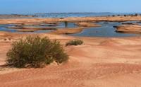
Lake Alakol (Itishpes).
Landmark – Kazakhstan.
“Anrakay is not located where Divaev points out, but 120 versts southeast of the southern tip of Lake. Balkhash, known among the Kazakhs under the name of Itishpes Alakul."
M. Tynyshpaev.
Best adventures in Kazakhstan.
Endorheic, salty lake Alakol or Itishpes (kaz. Alakoli, Itishpes, Itishpestin) is located at an altitude of 339 m. a. s. l., is located southwest of Lake Balkhash from bays of Shekpek and Airyk, on territory of the Balkhash district of Almaty region and Moiynkum district of Zhambyl region.
The border between the two regions divides the lake from southeast to northwest. In high-water years, Lake Alakol connects with the southern part of Lake Balkhash and then the absolute water level reaches 342 m. a. s. l. The average area of the lake water area is about 221 square kilometers (03.2023), the perimeter is 91 kilometers, the depth reaches 0.5 - 1.0 meters.
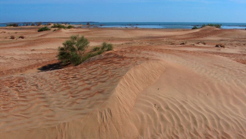
Lake Alakol is identified with an earlier name - Itishpes (Kazakh dog will not drink), which was used by researchers to indicate the place of the Anyrakai battle that took place in the spring of 1730. It should be noted that the proposed location of Lake Itishpes is located at the place indicated on topographic maps as the Alakol salt marsh, which is the most southwestern part of Lake Balkhash.
It must be assumed that when the water level in Balkhash rises, the Alakol saline land is filled with water, which moves from the lake to the depression of the saline land. A lake with a perimeter of 52 kilometers and an area of 154 square kilometers is formed.
“In all the above-mentioned cartographic and documentary sources of the second half of the XVIIIth-mid-XIXth centuries, this lake invariably appears in the metaphorical phrase Itichmes - Alakul or Itichsny - Alakul (correctly Itishpes-Alakol - I.E.), which very capaciously conveys it traditional folk etymology.
n the “Description of Lake Balkhash”, prepared in 1853 by the Russian military topographer Sobolev, regarding Lake Alakol, it is stated that the water in it is “bitter and even deadly, having some special pungent taste.” In another untitled “Description” of the same lake, compiled a little later, but also in the middle of the XIXth century, it is said that “it has bitter, stuffy and even deadly water for animals, i.e. animals and birds; and in the vicinity of it there are always bones of probably dead animals that have drunk this water.
Geologist B.F. Meffert, who visited the Southwestern Balkhash region in 1910, in a special article written by him two years later, in turn, noted: “All the lower parts of the Alakul coast are highly saline, the water off the coast of Alakul is bitter-salty and almost unsuitable for consumption ".
From this follows an unambiguous conclusion that under the historical lake Itishpes, the informants of A. A. Divaev had in mind only Lake Alakol, and not any other bitter-salty lake of Western Zhetysu, since in addition to the former Balkhash Bay none of the Chu-Ili lakes in cartographic and documentary sources of the XVIIth - XIXth centuries. under this historical name is not mentioned.
According to the folk legends of the Kazakhs, recorded at the beginning of the last century by A. A. Divaev, the Anyrakai battle took place near the Anyrakai mountains in the foothills, gravitating towards Lake Itishpes-Alakol. i.e., on the so-called "Alakul side" of this reservoir.
It is quite obvious from the above lines that their author, speaking of the second geographical landmark of the legendary Anyrakai area, did not mean at all the region of the northwestern, i.e. Balkhash, coast of Lake Alakol, from where it is very difficult to penetrate by land to the Anyrakai mountains , but the actual territory located southeast of Alakol.
A comprehensive geological and geomorphological study of the Anyrakai Mountains area, carried out for the first time in 2005-2007, made it possible, finally, not only to resolve the controversial issue of localizing the battle site, but also to identify those specific features of the landscape that undoubtedly became decisive in the choice of strategy and tactics of the battle of Anyrakai in 1730.
Geomorphologically, the Alakol plain, or the so-called "Alakul side" of Lake Itishpes. represents nothing more than a zone of direct transition (in the direction from west to east) of the foothill plains of the northwestern ridges of the Chu-Ili mountain system to the vast slightly undulating plain of the Zhusandala steppe and is the lowest section of the eastern periphery of the Khantau and Anyrakai ridges.
Due to such a low hypsometric position of this "border" strip of foothill plains in relation to the more elevated areas of the foothills of the northwestern group of the Chu-Ili mountains, here the groundwater horizon is wedged out, due to which a large number of solonchaks, or takyrs, are formed on its surface.
The latter constitute an extended and almost continuous chain of swampy bitter-salty lakes in winter and early spring, stretching from Alakol at a distance of several tens of kilometers in a southeast direction to the Sarybulak river and the Beskol valley.
Indicative in this sense is the folk etymology of the Kazakh toponym Beskol, which in translation into Russian means “Five Lakes”. It reflects the real attraction of this area, as one of the sections, or rather, the southernmost section, of the extended zone of solonchaks of the Alakol plain; in addition, paleoclimatic studies conducted in 2007 unequivocally indicate the presence of large reservoirs (lakes) in this area in a more humid and warm climate, and the era of the late Middle Ages and modern times differs from modern ones.
In the relatively recent past, large concentrations of takyrs, starting from the southwestern coast of Balkhash, apparently produced on the local residents of the region the visual effect of the continuation of the Alakol water basin, which moved forward like a wedge far forward in the southeast direction at the confluence of the steppe Zhasandala with the flattest strip of the Anyrakai sloping plain.
Geographic coordinates of Lake Alakol: N44°52'54 E74°18'09
Authority:
Alexander Petrov.
"Anyrakay Triangle Historical-Geographical Area and Chronicle of the Great Battle". I.V. Erofeeva, B.Zh. Aubekerov, A.E. Rogozhinsky, B.N. Kaldybekov, B.T. Zhanaev, L.L. Kuznetsova, R.D. Sala, S.A. Nigmatova, J.M.P. Deom. Almaty, 2008. "Dyke Press".
Photos by
Alexander Petrov