


![]()
You are here
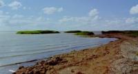
Lake Alakol in Akmola region.
Lakes of Akmola region.
"I am today a pine mill
Overtaking on all roads.
I took a tulip today -
Like a child by the chin"
Marina Tsvetaeva. August 16 - 17, 1936.
Fishing onlakes of Central Kazakhstan.
Freshwater Lake Alakol is located at an altitude of 351 m. a. s. l., located in northwestern part of vast Muzbel valley, 42.5 kilometers southeast of settlement of Korgalzhyn, 32 kilometers to south and slightly west of village of Kenbidaik, in eastern parts of Korgalzhyn district in southwestern part of Akmola region.
In the north of the lake there is the Araltobe tract, in the north-west there is a small lake Bolgan, in the south the lake is supported by the drying-up lake Kurkildek. The area of the lake is 50.5 square kilometers, the length of the lake is 5 kilometers, the greatest width is 1 kilometer, the length of the coastline is 36 kilometers, the average depth is 1.3 meters, the greatest depth is 4.5 meters.
The volume of water is 71,000,000 cubic meters, the catchment area is 1240 square kilometers. The shores of Lake Alakol are steep, 4.5 meters high, clayey-loamy, the bottom is flat, silty (silt thickness 0.4-0.5 meters). long the banks of the basin there are reed thickets.
The water level is maintained by spring snowmelt, atmospheric precipitation and partially groundwater. The average annual fluctuation in water level is 0.4 - 0.5 meters, in a long-term context it is 4.5 meters. During the dry years of 1936, 1949, 1950-1952, the lake dried up.
The fish resources of Lake Alakol are small. Most of the coastal territory is plowed, the rest is used for grazing farm animals, and is covered with fescue-feather grass, wormwood and, in places, saltwort vegetation.
Geographic coordinates of Lake Alakol: N50°26'35 E70°34'34
Authority:
Brief Encyclopedia Kazakh SSR, Volume 2, Nature, Alma-Ata, 1990. T.R. Omarov.
Photos by:
Alexander Petrov.