




You are here
L. V. Meyer on Syr Darya delta (1861).
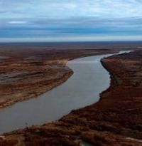
Distributaries of Syr Darya River.
"The land of Zheshi has a circumference of about 1,000 *li*. Its western border runs along the She River. The country is narrow from east to west and elongated from south to north. Its products and climate are the same as those of the land of Nuchijian. There are several dozen cities and settlements, each with its own ruler. As there is no single king, they are subject to the Tujue [Turks]. From there, I traveled south for about 1,000 *li* and arrived in the land of Sudulisena. The land of Sudulisena has a circumference of 1,400–1,500 *li*. Its eastern border runs along the She River. The She River originates in the north of the Congling Mountains and flows northwest. Spreading wide and carrying turbid waters, it surges and rushes rapidly. The products and customs [of the inhabitants] are the same as those of the land of Zheshi. They have their own ruler and are allied with the Tujue."
Suan Zang. His major historical-geographical work is *Great Tang Records on the Western Regions*. Work on this book was completed in 646 (some sources cite a final revision in 648), shortly after the monk returned from his 17-year pilgrimage to India. The journey itself - passing through the region of Lake Issyk-Kul - had taken place much earlier, around 630.
Zhanadarya and Kuandarya are distributaries of Syr Darya.
Another somewhat inaccurate expression is the very name of the Syr Darya River; Up to this point, we have scarcely touched upon the Syr Darya itself, having established a presence only in its delta - specifically, by occupying several of its distributaries where it empties into the Aral Sea.
The following account illustrates this. Fort Perovsky is the only outpost located on the Syr Darya proper; the river begins to branch out downstream from this point. The first distributary, the Zhany Darya (Yany Darya), separates a few versts west of the fort and flows southward, while the second, the Karauzyak, flows northward.
From the point where this latter branch diverges, the river is known as the Dzhaman Darya; the Kuvan Darya branch subsequently splits off from it, heading southwest. With the exception of the Karauzyak - which rejoins the Dzhaman Darya near Fort No. 2 - all these branches once flowed into the Aral Sea, and the main channel of the Dzhaman Darya still reaches it today.
The reader may find a detailed description of them in an article by Mr. Maksheev; here, we discuss only two branches that were not yet fully explored at the time: the Zhany Darya and the Karauzyak. From its source at the Syr Darya to the ruined fortress of Dzhan-Kala, the Zhany Darya flows in broad reaches and forms extensive floodplains covered with dense reeds.
Along this stretch, the river should be navigable - the only potential obstacle being the reeds - but further downstream, it flows through a narrow channel and, some 30 versts before reaching Lake Akcha-Kul, sometimes dries up completely in the summer. At present, its entire lower course is entirely unsuitable for navigation.
The information I gathered from Kyrgyz oral traditions regarding the course of the Zhany Darya appears to align well with on-site surveys, though it differs somewhat from accounts collected previously. About a century and a half ago, the Zhany-Darya was known as the Inker-Darya ("Disobedient Darya").
It branched off from the Syr Darya upstream of Fort Perovsky, near the Bok-Tulen locality, and flowed parallel to the main river as far as the Khan locality; from there, it turned - as it still does - southwest toward Lake Kukcha-Tengiz and continued across the Kyzyl-Kum Desert to Lake Dzhailende-Karakul (likely the area now forming the Amu Darya overflow near the Dau-Kara locality).
It was dubbed the "Disobedient Darya" because of its sluggish flow between Kukcha-Tengiz and Dzhailende - a characteristic that ran counter to the interests of the Karakalpaks living along its banks. However, toward the end of the previous century, the Inker-Darya’s headwaters began to silt up, and the current weakened significantly.
The Karakalpaks living at Kukcha-Tengiz at the time were unable to clear the channel; deprived of water, they were forced to abandon the area early in the current century and relocate to the Amu Darya delta. Subsequently, a change occurred at the source itself: local inhabitants dug an irrigation ditch at the spot where the Zhany-Darya now begins, and the water, rushing into the ditch, carved a path through to the old Inker-Darya riverbed.
Thus, a flow was re-established along the channel, which came to be known as the Zhany-Darya ("New River"). Around 1820, the Kokandians established a presence in the area by building the Ak-Mechet fortress. As Lieutenant Colonel Maksheev recounts, the new rulers dammed the river and guarded the dam until 1852; the Russians, having replaced them, likewise sought to retain the water - albeit for different purposes.
However, since 1857, water has been flowing continuously along the Zhany-Darya and has already reached the Akcha-Kul and Kukcha-Tengiz lakes. That is what the legend says; yet the river has written its own history - one that is, in fact, quite similar to the account just cited.
The Zhany-Darya flows past a series of old fortresses - all in a southwesterly direction - as far as Mount Bish-Mazar; it then turns south and terminates in a lake right at the edge of the Kyzyl-Kum sands. Channels, now dry, extend southward from this last lake; it was likely through these that water once made its way to the Dau-Kara tract and joined the waters of the Amu-Darya.
Although I personally have not had the opportunity... ...trace these channels as far as Dau-Kara; however, certain circumstances point to the veracity of the tradition. Along the edges of these channels - at the foot of the hills - one can still see rows of reed roots; although completely decayed, they remain easily recognizable.
Old reeds of an identical appearance are found in the channels running northeast from the lakes toward the Dau-Kara tract. In the dry channels of Lake Kukcha-Tengiz and Lake Dau-Kara, I discovered a multitude of freshwater shells, whereas in other tributaries the shells were exclusively marine, indicating they belonged to a different era.
This hypothesis is further supported by the fact that the rise of land against which Lake Kukcha-Tengiz abuts clearly belongs to the same geological formation as the mountains surrounding the Dau-Kara lakes. These mountains are composed of sand mixed with mica and rest upon a clay stratum.
It is reasonable to assume that the entire region underwent a slow yet simultaneous uplift, thereby permanently severing the waters of the Syr from those of the Amu Darya. I am convinced of this local uplift by the aforementioned reed remains, which run in rows along the edges of the sands; notably, these rows do not lie on a single horizontal plane but extend, in part, along the slopes of the hills.
Had the land not risen, these rows would necessarily be horizontal, reflecting the water level at the time the reeds grew.
I believe this phenomenon occurred no more than a century ago - likely during the period when the Karakalpaks observed the sluggish flow of the Inker Darya as it moved from Kukcha-Tengiz toward Dzhaylenda. It is quite possible that this uplift is still ongoing; in any case, it is evident that the Zhany Darya will never again flow through these channels.
So far, we have discussed one legend and the corresponding trace left by the river itself; however, there is another account, and for it, too, there is an explanation found in nature. In 1849, in the southwestern part of the Aral Sea, the Kyrgyz people showed Captain Butakov the mouth of a river and called it the Zhany-Darya - how, then, is this to be explained?
Let us return to Mount Bish-Mazar; the river flows to this point today just as it has for centuries. From this mountain, one can indeed trace a dry riverbed westward through the sands, extending from the bend of the Zhany-Darya all the way to the sea, into which it once emptied via two branches: the Basuzyak and the Kara-uzyak.
Although I saw no organic remains along this entire channel, the riverbed itself is clearly defined. The shoreline of the Aral Sea consists of numerous bays - both deep and shallow - that are now partly dry and partly marshy; all are filled with seashells and evidently once formed the seabed. In the Zhany-Darya’s channel, however - as mentioned earlier - I saw no shells; this is likely because freshwater shells, being fragile, disintegrated over time.
There is no doubt that the Aral Sea is receding from the western shore, as the Kyrgyz clearly remember water in places that are now completely dry; one can even trace this retreat within the dunes, noting that the closer one gets to the sea, the fresher the shells appear and the better they have retained their color.
The Zhany-Darya did indeed flow along this channel in the distant past, and the Kyrgyz account is entirely accurate, though it has been handed down through oral tradition. That this watercourse is far older than the first is also evident from the fact that there are no fortress ruins along it, unlike along the first one; Only the highly questionable embankment of the Kum-Bugut dam indicates that human labor was once employed here.
It was along this route that the Zhany-Darya merged with the Kuvan, as depicted on old maps. My belief that this entire area is still rising today is further supported by Captain Butakov’s astute observation that the mouths of the Syr-Darya are steadily shifting northward.
While everything I say here is, of course, merely conjecture, it seems to me the only way to reconcile local tradition with what I observed on the ground. As previously mentioned, the Zhany-Darya terminates at Lake Kukcha-Tengiz, forming a small expanse of water known as Akcha-Kul about a *verst* before reaching it.
Kukcha-Tengiz actually consists of two lakes and a third inlet, all connected by straits. The main lake measures approximately 20 *versts* from north to south and about 3 *versts* in width; the others are somewhat shorter and narrower but extend along the same meridian.
Their water is entirely fresh; the banks consist of sandy hills, though the immediate shoreline is clayey in places. Akcha-Kul is surrounded by clayey saline soil that is highly suitable for agriculture. For the sake of completeness, I will add a few words about the Dau-Kara tract.
Here, water collects in three main lakes: Kungrad, Kara-Teren (or Zhuyryuk), and Butun-Kul. There is no doubt that this area was once the bed of a single large lake; consequently, it was marked as Lake Dau-Kara on old maps. Today, water reaches this area exclusively from the Amu-Darya via the Kuvan-Shirma channel and flows into the Aral Sea through the Yangi-su channel.
A chain of sandy hills containing mica adjoins these lakes to the north. The entire area west of Lake Kukcha-Tengiz and the Zhany Darya consists of rows of sandy hills covered with shrubs and intersected by old sea inlets. These inlets are now barren salt flats, almost devoid of vegetation.
Another branch of the Syr - recently explored, Karauzyak, is nothing more than an irrigation ditch dug by the Karakalpaks, which due to time and favorable circumstances has now turned into a deep channel. In the middle of its course, the Karauzyak forms many lakes covered with extremely thick reeds.
Through these reeds the main mass of the waters of the Syr are filtered, as Captain Butakov very correctly noted; but this straining is precisely a very harmful circumstance. Recently they have been trying to clear the fairway here; I don’t know to what extent it will be possible, but even if we allow for the possibility of steamships sailing along the Karauzyak, the benefits of this channel will not compensate for its harmful effect on arable farming throughout Syr.
Here, arable farming is possible only with irrigation, therefore success depends on the convenience of watering, and for successful irrigation a known height of water in the river is necessary. The Karauzyak, drawing most of the water into its channel, which is lower than all other branches, will sooner or later completely absorb their waters and turn their banks into barren salt marshes.
Karauzyak itself, due to the nature of its banks, is inconvenient for arable farming. It can be noted that this same Karauzyak pours its waters back into the Syr Darya at Fort No. 2, and therefore, below this place the river level should not decrease.
Anyone familiar with the power of evaporation in these latitudes will easily understand that in fact not all the water reaches the main river again; on the vast expanse of Karauzyak spills, about 2000 sq. miles, evaporation uselessly absorbs most of the water.
Taking into account that the height of the water in the river is a vital condition for arable farming in the Syr, which is currently in great decline, one involuntarily comes to the conclusion that the surest way to achieve the goal is to dam the Karauzyak.
This, on the one hand, will raise the water level of Jaman and Kuvan Darya, and the first river, having dug several sharp turns, will become convenient for navigation; on the other hand, the bottom of Karauzyak, since it is lower than the bottom of Jaman Darya, can always be supplied with water, and therefore will also provide a convenient place for crops.
This work, of course, is not small, but I repeat, this is the only radical means of bringing the matter to a good result; all the minor adjustments will lead to nothing, the main inconvenience will always remain - I mean a decrease in the water level throughout the Cheese.
That this is not a speculative conclusion, but a practical conclusion from observation, is evidenced by the traces of extensive arable land that formerly existed in Syr, where there is now a desert, and there can be nothing else. Usually the current lack of culture in Syr is explained by wars and robberies, but this is only one of the reasons, if not a consequence; the main reason lies in nature itself: if the water had maintained its level, that is, it would have provided a constant opportunity to engage in arable farming, the communities that were here would have resisted enemy raids, but they were conquered by need, and the raids of robbers, preventing the inhabitants from fighting nature, completed the job.
Finally, the inhabitants could be subjugated and continue to go about their business, and not retire, as happened, to the Amu Darya, where they are no more secure from robberies.
Authority:
Lev Lavrentievich Meyer. “Delta of Syr Darya River and its relation to Russia” Marine collection, No. 9. 1861.
https://www.vostlit.info/Texts/Dokumenty/M.Asien/XIX/1860-1880/Meier_L/text2.htm?utm_source=chatgpt.com
Photos by:
Alexandr Petrov.