


![]()
You are here
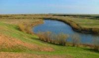
Kulanotpes River in Korgalzhyn reserve.
Tours of sights of Korgalzhyn reserve.
“The Kulan-Itmes River flows into the same lake (Kurgaldzhin), east of the mouth of the Nura, receiving the Yakshi-Kun River, remarkable for the abundance of grass along its banks.”
Levshin A.I. “Description of the Kyrgyz-Cossack or Kyrgyz-Kaisak mountains and steppes.” 1833.
Boat trip on Korgalzhyn reserve.
Kulanotpes River is located at an altitude: at mouth 306 meters above sea level, at source 618 meters above sea level, river flows through territories of Karaganda and Akmola regions, through territory of Korgalzhyn Nature Reserve and flows into swampy eastern part of Lake Big Tengiz.
The sources of the river are in the northern part of the Karaganda region. The length of the river is 220 kilometers from the beginning of its sources. The sources of the river are located on the northern slope of Mount Umarbek, 803 meters above sea level.
The river's tributaries are small, typical steppe rivers flowing through the territory of the Korgalzhyn Nature Reserve. The annual flow of Kulanotpes is 132,000,000 cubic meters. The river is characterized by high spring floods, when the water level rises by 4 - 5 meters, and low low water.
They have a constant flow only in the spring; by the end of summer they dry out, with the preservation of individual reaches. The duration of drying out is on average 127 days, with a maximum of 250 days. River water is characterized by increased mineralization, especially in autumn.
At 175 kilometers from the beginning of the source, the Kon tributary flows into the Kulanotpes on the left. Just north of the village of Barshino, the Kon River is formed from the confluence of two tributaries - the western Zhaksy-Kon and the eastern Zhaman-Kon.
Not far from the mouth of the Kon River in Kulanotpes, the Zhaman-Kon tributary flows into the Kon on the right. The Zhaksy-Kon River is formed from the confluence of two rivers: Saryturgan, which originates in the Saryzhal mountains and Taldysay, which originates from the northern slopes of the Ospantau ridge.
The river flows to the northeast and then from the village of Barshino turns north and flows to the mouth in Kulanotpes. The mouth of the Kona is located just north of a small steppe village called Kulanutpes. The length of the river is 160 kilometers. The catchment area is 4050 square kilometers.
The channel in the upper reaches is narrow, the coastline is unstable. In the middle and lower reaches there is a floodplain up to 2 - 3 kilometers wide, overgrown with meadow vegetation. In this case, the channel splits several times into several branches, running parallel to each other and connecting back.
The average annual water flow is 0.82 cubic meters per second. The annual flow of the river is 53,000,000 cubic meters. The flow regime is subject to significant seasonal fluctuations. In spring, the water level can rise by 4 - 5 meters, and during low water it drops significantly.
By the end of summer, the river partially dries up, breaking up into separate reaches. The duration of the dry period is on average 127 days, but in some dry years it can increase to 250 days. The water in the river is characterized by increased mineralization, especially in the autumn. Some reaches remain brackish all year round.
There are irrigated pastures in the river valley.
Geographic coordinates of Kon River: N50°05'04 E69°29'31
At 198 kilometers from the beginning of its sources, the Kulanotpes River receives a right tributary, Kolshun, in a swampy area near the mouth of the Karachi valley, south of Lake Yesenkol. At 209 kilometers the river receives a second tributary from the right, Tabiyak, which in turn merges with the Kolshun River.
The mouth of the river is located on the floods of the Karachi tract, west of Lake Kyzylkol, located at an altitude of 305 meters above sea level.
Geographic coordinates of Kolshun River: N50°18'40 E69°28'27
In May 1958, by decree of the Council of Ministers of the Kazakh SSR, the Korgalzhyn steppe reserve was created along Lake Korgalzhyn and the Kulanotpes River; its area was 15,000 hectares.
Geographic coordinates of Kulanotpes River: N50°14'36 E69°27'35
Geographic coordinates of sources of the Kulanotpes River: N48°57'16 E71°15'07
Authority:
Alexander Petrov.
"Korgalzhyn State Nature Reserve." Sidorova T.
Photos by:
Alexander Petrov.