


![]()
You are here
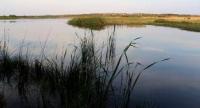
Korgalzhyn lake.
Bird Watching Tours Korgalzhyn reserve.
“Kurgaldzhin takes in the Nura River, has about 200 miles in circumference, and is divided into two parts by a long narrow peninsula. Its depth is quite significant, the water in it is bitterly salty, the southern and eastern shores are covered with high and impenetrable reeds, which the Kirghiz, who roam the islands and along the banks, use instead of firewood. There are different types of fish in Kurkaldzhin. In addition to the Nura, the Yakshi-Kun and Uch-Kashyn rivers flow into it.”
Levshin A.I. “Description of the Kyrgyz-Cossack or Kyrgyz-Kaisak mountains and steppes.” 1833.
Reserve tour in Korgalzhyn.
Korgalzhyn Lake is located at an altitude of 305.5 m. a. s. l., located in north of Kazakh small hills, at bottom of Tengiz-Korgalzhyn depression, Korgalzhyn National Reserve, in Korgalzhyn district in southwest of Akmola region.
Lake Korgazhyn has an area of 330 square kilometers, the length of the coastline is 187 kilometers, and is part of the Tengiz-Korgalzhyn lakes system. The area at the end of the 50s of the last century was 315 square kilometers with a length of 30 kilometers and a width of 20 kilometers (Starikov, 1960), at the end of the 90s - 471 square kilometers with a length of 36 kilometers and a width of 30 kilometers (Tursunov et al. , 1993).
The length of the lake is 33 kilometers, the greatest width is 21 kilometers. The long-term amplitude of water level fluctuations is 3 meters. The maximum depths do not exceed 2.5 - 3 m. The average depth is 1.6 meters. In 1940, the lake was completely dry (Posokhova, 1949).
The volume of water in the lake is approximately 0.5 cubic kilometers. The catchment area is 55,000 square kilometers. The northern shores of the lake are up to 4 - 6 meters high) and the eastern shores are steep, the western and southern ones are flat, with characteristic reed vegetation.
The bottom is flat, clayey, covered with gray or black silt. Snow food. The Nura River flows into Korgalzhyn. During the spring flood, water from the lake is discharged along the Nura into Lake Tengiz. The mineralization of water varies in different parts of the lake: near the mouth of the Nura River the water is fresh, in other parts of the lake it is brackish.
The range of changes in water mineralization is from 0.7 to 3.5 g/l. Total mineralization of water – from 0.648 to 2.486 g/l. Chemical composition - sodium chloride. There are about 40 islands on the lake, the largest of which are Aral-Tyube, Kokpekty and Zhar-Tyube.
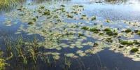
There are also floating islands on which colonies of gulls and terns settle and ducks and grebes nest. The lake is rich in fish (crucian carp, mirror carp, pike, tench, ide, perch, etc.). The coast is home to swans, osprey and other birds. Wild boar can be found in the reeds.
In 1976, the Tengiz-Kurgalzhyn lake system was included in the list of wetlands of international importance subject to the Ramsar Convention. On the lake there is a kingdom of reeds and cattails, their thickets occupy 70 - 80% of the water surface.
The reed divides a single body of water into several large bays and many reaches that have their own names. The largest of them are located in the northern part of Kurgaldzhin: Yesey, Sultan-Keldy, Kokai and small Karakol, Taban-Kaza, etc. In 1940, Lake Kurgaldzhin completely dried up, and in Lake Tengiz water remained only in a small area of the reach and along the bottom a road was built across the lake.
Numerous other lakes in the vicinity of the reserve are located at the bottoms of closed depressions and are characterized by shallow water, as well as variable area. In the spring the lakes overflow, and in the summer they sharply decrease in size and even dry up.
Salt lakes turn into salt marshes and litter, and fresh lakes are almost completely overgrown with reeds, reeds, and wheatgrass. The salt lakes Tuz and Aktailak have reserves of table salt and medicinal mud. Mud is not used due to the remoteness of the lakes from populated areas, and table salt, due to non-compliance with the state standard, has no industrial value.
The main source of replenishment of water reserves in lakes is winter precipitation during the snowmelt period. The influx of water usually occurs only in spring flood along steppe rivers that poorly drain the area, and temporary watercourses - Kara-Su.
In high-water springs, the amount of water entering the lakes exceeds the norm by 5 - 8 times, and in low-water springs there may be no runoff from the catchment area. Wetland vegetation is developed in the southeastern part of the reserve and covers a significant area of Lake Korgalzhyn.
In 1944, during the period of enthusiasm for acclimatization, the fauna of Lake Korgalzhyn was replenished with a new species - the muskrat. It multiplied quickly, and in the late 60s - early 70s its numbers were very high.
As a result of overpopulation, an epizootic of tularemia broke out among muskrats and water rats, and almost all the animals died.
In the 1980s, the muskrat population began to recover.
Geographic coordinates of Lake Korgalzhyn: N50°26'26 E69°32'32
Authority:
"Korgalzhyn State Nature Reserve." Sidorova T.
Photos by:
Alexander Petrov.