


![]()
You are here
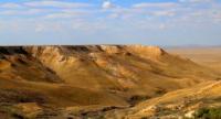
Kolenkely mountains.
Tours Kazakhstan.
“Let's not ... be too deluded by our victories over nature. She takes revenge on us for every such victory."
Engels Friedrich.
Last minute tour Kazakhstan.
Kolenkely mountains, a typical fragment of the northern part of the Ustyurt plateau, located 122 kilometers to the east and slightly east of the regional center - Beineu, 105 kilometers to the east and slightly north of the Karakum sands, 20.4 kilometers to the east and slightly south of the mountain range Sholkara, 75 kilometers east and slightly north of the village of Borankul and 57 kilometers west of the Donyztau valley-saline land in the Beineu district in the northeast of the Mangistau region.
The Kolenkely mountains are partially in the latitudinal direction south and north, gravitate towards the east, thus the length of the mountains is 38 kilometers, the maximum width of the northern part is 3 kilometers, - 5 kilometers in the southern part, the width reaches 2 kilometers.
The dominant unnamed mountain elevation is located in the northern part with a height of 214.4 meters above sea level, in the central part of the mountains an elevation of 209.4 meters above sea level dominates.
In the central and southern parts, there are several good fellows. In 57 kilometers to the east of the Kolenkely mountains there is the Donyztau salt marsh tract, from the west the mountains are bordered by salt marshes, from the southeast, 22 kilometers away are the Konyrtobe mountains.
The territory of the mountains is one of the most inaccessible, least explored, the nearest settlement is located 75 kilometers to the west - the village of Borankul (formerly Oporny). The relief is mountainous elements of the mountain landscape with high cliffs, outcropping rocks, outliers, deep and extended ravines, gullies.
The region is rich in paleontological finds - oyster shells, teeth of Paleogene sharks, vertebrae of bony fish living in the Tethys Ocean about 40 million years ago. In the eastern part of the mountains on cliff, in the central and northern parts, there are several necropolises and settlements, which were confined to a water source.
Geographic coordinates of the Kolenkely mountains: N46 ° 22'58.70 "E55 ° 22'46.86"
Authority and Photos:
Alexander Petrov.