


![]()
You are here
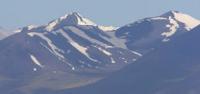
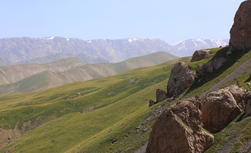
Kekkiya ridge.
Mountain ranges of Kyrgyzstan.
"To the west this ridge becomes lower and already represents a smooth straight ridge; from the interval of the main peaks of the Zaaksai ridge a crack blackened, the steep cliffs of its back edge, rising above the front, were visible; in this crack the river Kok-kiya flows into Aksai, giving its name to the ridge. The ascent to it to the foot of its rocky peaks represents a wavy, gentle slope, but the peaks themselves are so steep that on half of their surface snow cannot be retained, from which bare dark cliffs protrude, and so on to the very tops. The peaks are connected by a steep rocky ridge, on which the eternal snows are separated by a bluish tint between the fresh ones, descending also to the upper half of the gentle slope, but its lower half was snowless, like the entire plateau."
"Journey through the Turkestan region and exploration of the mountainous country of Tien-Shan." N. Severtsov. 1873.
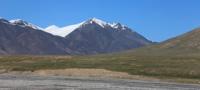
Mountains of Naryn region of Kyrgyzstan.
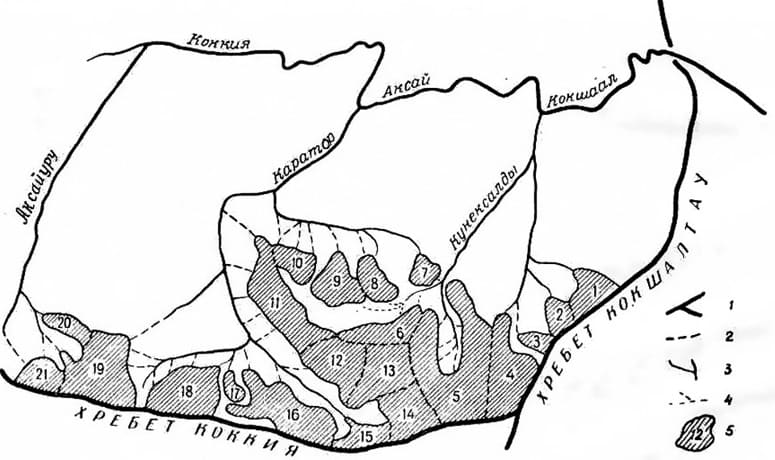
Kekkiya latitudinal ridge is located in western part of Kokshaal-Too ridge in At-Bashinsky district of Naryn region. Eastern border of ridge begins with Chinese territory located on right bank of Kokshaal (Tuoshigan) River, western is located on right bank of Kok-Kiya River.
The length of the ridge from east to west, from the Western Kokshaal-Too ridge to the valley of the Aksaykuru river is 15 kilometers. The greatest width is 4 kilometers. The average height of the ridge is 4500 meters above sea level.
The dominant height of the ridge is a summit with a height of 4848 meters above sea level located in the central part of the ridge. From the south and west, the ridge is bounded by the Aksayuru River, 31 kilometers long, which originates from small glaciers located in the ridge on the southern side of the ridge.
Along its entire length, Aksuyru has 15 right tributaries, which begin from the southern slopes of the ridge. 8 right tributaries flow into the river in the western part of the ridge. One tributary begins from the western slope of the Chon-Uru pass.
At the junction of Kekkiy with Western Kokshaal-To, there is the state border between the Kyrgyz Republic and the Republic of China. The northern border of the ridge is the source of the Karator River, 16.5 kilometers long, in the place where the main river bed turns to the east.
The eastern border of the ridge is the Western Kokshaal-Too ridge. Glaciation of the slopes, as in the entire region, is present only in its northern part. In the crest zone of the ridge at an altitude of about 4300 meters above sea level, there are snow-glacial formations in the form of fields of snow and glaciers of flat tops.
They occupy the upper reaches of the rivers Kuneksaldy (12 glaciers), Karator (19 glaciers), Aksaiuru (6 glaciers). 73% of their total number are flat-topped glaciers. It should be noted that most of the year the glaciers of the flat tops of the Kokkiya ridge are completely covered with snow.
Flat peaks, located at an altitude of 4400 meters above sea level, have a peculiar effect on the formation of snowfields and glaciers. First of all, they are unfavorable for the accumulation of snow, since in winter it is blown away by the winds.
This phenomenon is widespread in almost all peaks of this type in the Tien Shan, Pamir, and Alai. However, in a number of cases, swept away snow forms dense snowfields and glaciers on the slopes in narrow gorges.
The height of the firn line is 4000 - 4200 meters above sea level, in some places it is caused by the influence of the processes of snowstorms carrying and blowing off snow. Glacier tongues are located at an altitude of 3900 meters above sea level.
The glaciation of the ridge consists of 8 main glaciers of different lengths located on the northern slopes, all glaciers belong to the headwaters of the Karator River of the Kokshaal River Basin. The description of the glaciers located in the Kekkya ridge is presented from east to west.
The most eastern is glacier No. 1 with a length of 4.5 kilometers originating from the ridge of the Western Kokshaal-Too ridge, the tongue of the glacier is at an altitude of 4316 meters above sea level. The next glacier No. 2 is 3 kilometers long, the tongue of the glacier is located at an altitude of 4199 meters above sea level.
Glacier No. 3 with a length of 1.7 kilometers originates from the crest of the ridge at an altitude of 4848 meters above sea level, the tongue of the glacier is at an altitude of 4151 meters above sea level. The southern spurs of the ridge are not extended for about 2 kilometers.
The northern spurs, in contrast to the southern ones, are highly dissected, their length is up to 12 kilometers. The relief is characterized by the presence of flat watersheds almost along the entire length of the ridge, not excluding some uplifts with sharp peaks.
Flat watersheds reach an average height of 4300 meters above sea level, and individual peaks rise to 4848 meters above sea level. The intermontane valleys of the Kekkyya ridge are quite deep, for example, the height of the Karator river valley in the central part is 3100 meters above sea level.
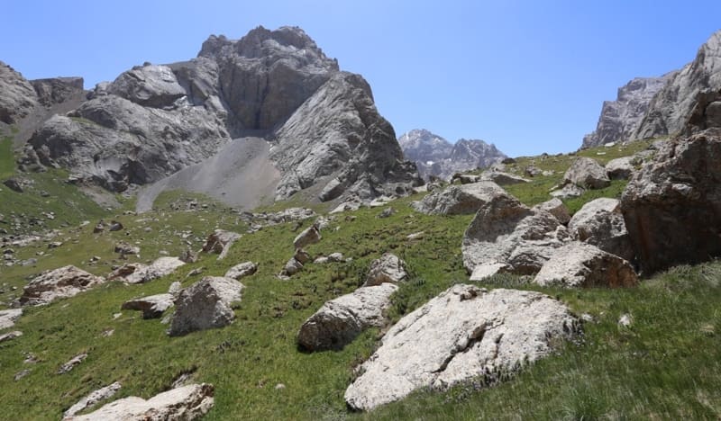
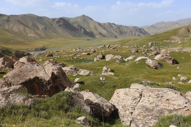
It follows from this that the difference in elevation from the valley to the pass is more than 1 kilometer. Basically, the passes here are rocky-ice or rocky-talus, depending on the exposure to the cardinal points. Mountain-forming rocks are mostly represented by marble and limestone.
To a lesser extent - basalts and granites. Along the foot of the slopes of the ridges, quite often there are outlier rocks of a bizarre shape - kekura (Kkur is a pillar-shaped or cone-shaped rock of natural origin, usually in rivers, seas or on their banks), as well as individual large stones that have landmark values.
The height of cakes is 10 meters or more, stones - 3 - 5 meters. The bottom of the intermontane valleys is flat or wavy-flat; The main obstacles when driving here are numerous gullies, cliffs of river terraces, as well as areas occupied by rocky placers.
Most of the rest of the valleys in the mountains look like gorges and gorges with steep rocky walls and a narrow bed heaped with stones, sometimes completely occupied by a river stream; movement along such valleys is very difficult, and sometimes impossible.
The soils are almost everywhere dominated by rocky and stony, and only in large intermontane valleys large areas are occupied by crushed stone loams and syrts. The territory is located in a seismically active zone; earthquakes registered here reached magnitudes of 9 or more.
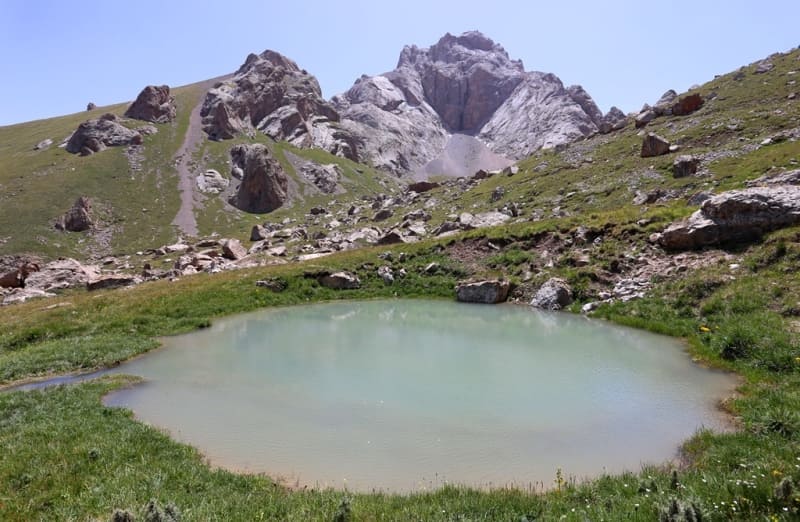
Rivers and lakes in Kekkiya ridge.
The largest rivers in the region are the At-Bashi, Ak-Sai, Kokshaal rivers, the width of the rivers is 15 - 25 meters, the depth is 0.5 - 1.6 meters, the current speed is up to 2 meters per second. The bottom of the channels is rocky or sandy-pebble, the banks alternately are high, steep, then low, gently sloping.
Over a considerable length, the beds of the At-Bashi and Ak-Sai rivers are divided into numerous branches and channels with a width of 3 to 10 meters. Between the branches and channels there are low sandy-pebble and stony islands, which are flooded during high water.
The rest of the rivers on the territory are up to 5 meters wide and up to 1 meter deep, the flow of the rivers is rapid, often with rapids and waterfalls. The banks are mostly high and steep. The main waterway of the Ak-Sai valley is the Ak-Sai river, which feeds mainly on the glaciers of the Kokshaal-Too ridge.
Due to the mild slope of the valley, the river and its tributaries have wide channels, divided into many branches. It is interesting that the river of the same name flows from the eastern part of the valley, merging with the “western” Ak-Sai not far from the Chatyr-Tash valley, at an altitude of 3000 meters above sea level.
After the confluence, the river is called Kokshaal and through a depression in the Kokshaal-Too ridge goes to China, to the Tarim depression, merging with the Sary-Jaz river. Huge volumes of these waters flow into the Lob-Nor lake, which is lost in the sands of the Takla-Makan desert.
The rivers fed by the glaciers of the Kekkiyya ridge are Aksayuru, Karator and Kuneksaldy. The Aksayuru River, originates in the southeastern part of the ridge. Kekkiyya, in the place where it adjoins the Kokshaal-Too ridge, bends around the Kekkiya ridge from the south, then flows into the Kokkiyya river from the west and in the north-western part of the ridge.
The river valley in the southern part is a floodplain with a wide flat rocky bottom. Relatively low slopes from the south create a feeling of comfort in it. The river itself is split into several streams with a width of 1 to 5 meters, a depth of up to 0.5 meters, with a current of 0.5 - 1 meters per second.
Slopes from the south and north in this part quite often form clamps. Turning north, the Aksaiuru River makes its way through the rocks. At the confluence of Aksaiuru and Kekkia, the river flows again in the canyon.
The height difference of the river is 400 meters (3700 - in the upper reaches of the river, 3300 meters above sea level - at the confluence with the Kekkia river). The Karator River is the main river fed by the glaciers of the Kekkiyya ridge.
It flows in the central part of the ridge, has many eastern and western tributaries. The tributaries of the river and its main channel originate in the hanging valleys near the main ridge and its central spur. In the southern part of the main channel, before turning into a wide valley, the Karator River flows in an unusually beautiful canyon up to 20 meters high.
The latter is easily bypassed along the coast, preferably the southern coast. he river valley in the central part is wide with a gentle rocky bottom. Here the river splits into streams with a width of 1 to 10 meters with a current speed of 0.8 - 1 m / s.
The volume of water in the river increases significantly by lunchtime. In the northern part, after merging with its largest western tributary, the river forms into one channel and flows into the Kokshaal river. The width in this part reaches 10 meters.
The mouth of the river is wide, about 50 meters. The Kokkiyya river is formed by two main tributaries - the Tuyuk-Botomoynok and Kel-Su rivers. V the southern (upper) part of the river flows in flood. The valley is about a kilometer wide, in places the valley is very swampy.
The river bed is 15 meters wide. In the northern part, the river mostly flows in the canyon. Here the width of the river is up to 20 meters, with a speed of up to 1.5 m / s. The Kekkiyya tributary, the Kel-Su river, is located between the eastern (Keltau mountains) and western Sarybeles ridge.
It starts under a natural dam under the lake of the same name. The rushing stream of water from numerous natural obstructions below the lake gives rise to the Kel-Su River. The width of the Kel-Su river in the middle part is about 15 meters, the current speed is 1.5 m / s.
Lake Kel-Su is located above the river of the same name and is a continuation of the Kurumduk River. The steep cliffs on both sides of the lake make it extraordinarily beautiful. The Tuyuk-Botomoynok river bends around the Keltau mountains from the east.
The river valley is wide with gentle grassy banks, swampy in places. Rivers freeze in November, open in March - April. The spring flood associated with the melting of snow accumulating over the winter on mountain slopes and in river valleys occurs in April-May, in June-July, during the period of intense melting of eternal snows and glaciers; rivers have a second - summer flood.
The lowest levels are established in September and are kept throughout the winter, right up to spring. The largest lake in the region is Chatyr-Kol. Its area is about 170 square kilometers, the depth, according to various estimates, lies in the range of 5 - 20 meters.
Of the 24 rivers flowing into the lake, only Kok-Aygyr has a permanent drain. Despite the fact that the lake is drainless, the total salinity of the water is low and is in the range of 0.5 - 1 mg / l. The water temperature in July-August ranges from 6 to 16 °.
In addition, there are many small lakes in the Ak-Sai valley - Kel-Su, Kosh-Kol and others. Some of them are formed by outcrops of mineral waters, but, due to the inaccessibility of the region, they are practically not studied.
Ground waters in the mountains are found at very different, but most often very significant depths. The depth of groundwater in the valleys is from 5 to 30 meters. On the territory of the At-Bashinsky region there are several mineral springs - narzans and calcium-carbonate. Some of them are used by the food industry of the region for the production of drinking mineral water.
Flora of the Kekkiya ridge.
There are few forests on the territory of the region, they consist of Tien Shan spruce and are concentrated on the northern slopes of the At-Bashi ridge. There are also areas of spruce woodland. The southern slopes of the massifs are completely devoid of forests due to both the exposure and the harsh, sharply continental climate.
The spurs of the ridge are less pronounced here, have a length of up to five kilometers and descend into the high-mountainous lifeless valley of the Ak-Sai River, which lies at an altitude of more than 3500 meters above sea level.
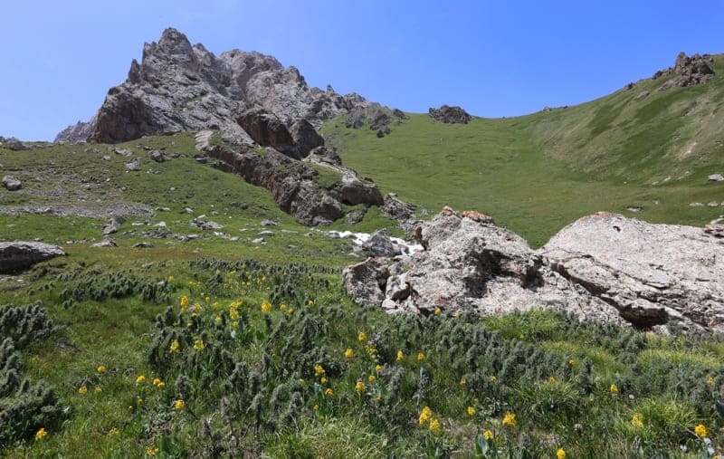
Archa (low-growing juniper) and some other shrubs grow along the deep river valleys in the mountains. Most of the mountain slopes are covered with low-grass meadows, and from an altitude of more than 3600 meters above sea level, various cold-resistant plants, often of a pillow-like form, begin to prevail.
The vegetation of large intermontane valleys is dry-loving, steppe. Typical landscapes of the grass-wormwood steppe at an altitude of 3100 - 3550 meters above sea level, fescue-feather grass steppe (3500 - 3800 meters above sea level), semi-desert and cold desert (3550 - 3800 meters above sea level) in various combinations are typical here.
Fauna of the Kekkiyya ridge.
The usual composition of the mountain fauna of Kyrgyzstan is represented in all its diversity in this region. Such rare birds as black stork, balaban, golden eagle, bearded man, mountain goose, steppe eagle, eagles, vultures, etc are found; mammals: mountain goat, Marco Polo ram, red wolf, gazelle, bear, lynx, leopard. In the area of Lake Chatyr-Kol, wild geese, ducks and other birds nest in thousands.
Climate of the Kekkiyya ridge.
The weather conditions in the region are quite stable and predictable. The driest weather and favorable snow and ice conditions occur in the first half of August. The wind rose determines the offensive of the fronts from the west and northwest.
The climate of the region is sharply continental. The average annual temperature here is minus 5 - 6 degrees, the maximum is +24, and the winter minimum is minus 50 degrees. In summer, at an altitude of more than 3000 meters above sea level, there are frosts every night.
Winter in most of the territory lasts from mid-November to March, inclusive (in large intermontane valleys - from mid-November to mid-March); this season is characterized by cold, mostly cloudy weather. The air temperature in the daytime, depending on the altitude of the area, varies from -3 to -15 degrees, at night - from -20 to -30 degrees (the minimum temperature is about -50 degrees).
Precipitation falls everywhere in the form of snow; the thickness of the snow cover on the lower parts of the mountain slopes and in the intermontane valleys is 1 - 2 meters, high in the mountains 5 - 6 meters, in some places up to 10 meters, in these areas there are frequent snow falls and avalanches.
Most of the snow falls here in the spring months. Until January, the valleys are practically snowless. Spring in most of the region lasts two months - April and May, in the valleys - two and a half months (from mid-March to May).
The weather in spring is unstable, as a rule, cloudy. The air temperature during the day ranges from 10 to -3 degrees, at night from 5 to -20 degrees. The largest amount of precipitation falls in spring (maximum in April).
Summer lasts from June to August; this season is cool and dry. Daytime temperatures range from 15 - 20 degrees, up to 5 - 7 degrees, and night - from 4 - 6 to 0, - 10 degrees. There is little precipitation in summer, mainly in the form of short showers or hail.
Autumn begins in September and lasts until mid-November with steady, clear weather. Snowfalls begin in the mountains since September. The temperature during the day varies from 12 to - 7 degrees, and at night from 0 to - 20 degrees.
Winds in the warm season are predominantly westerly, in the cold - easterly; prevailing wind speed 2 - 3 m / s. The strongest (15 m / sec and more) winds usually reach in winter. The territory is also characterized by local mountain-valley winds (breezes) of small and medium strength, at night and in the morning they blow down the slopes of mountains and valleys, and in the afternoon - in the opposite direction.
Due to the peculiarities of the orography, the most humidified are the northern slopes of the Kokshaa-Too, Kokkia and Sarybeles ridges, where modern glaciers are most widespread. Air humidity also has a great influence on the development of glaciation.
The relative humidity in the summer months in the area of the Aksai and Chon-Uzengegush rivers averages 65 - 70%, which is a relatively sufficient saturation of air with moisture, while the relative humidity in the Eastern Pamirs is in the range of 21 - 28% and often drops to 9%.
Geographic coordinates of Kekkiya ridge: N40 ° 45'57 E76 ° 34'54
Authority and photos by:
Alexander Petrov.
http://westra.ru/reports/tianshan/m06shamb3.html