


![]()
You are here
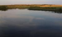
Kabyrga channel in Turgai river basin.
Trips on rivers in Kazakhstan.
“Have you heeded my prayer at least once, O firmament?
Rotating, you again made a cycle,
But I have the same sorrows and torments.
So bleak life, probably, will pass.
Baba Tahir. "Both heaven and earth..." End of X – XI centuries.
Rivers of Kostanay region.
The swampy channel Kabyrga is located from the source at an altitude of 135 meters above sea level and at the mouth at an altitude of 80.5 meters above sea level, 258 kilometers long, is the left branch of the Kara-Torgai River, which is located 5.4 kilometers to the north west of the village of Urpek, in the Dzhangeldy district in the south and southwest of the Kostanay region.
In a place where a channel departs from the Kara-Torgai River, and after 3 kilometers a tributary of the Zhaldam flows from the right, from here the river receives a new name - Torgai. The branch of the Kabyrga duct stretches for 2 kilometers in wetlands, then a 13-kilometer canal was laid in the old channel of the duct, which later forms the main channel of the Kabyrga.
After 28 kilometers from the beginning of the channel, the main channel of the Kabyrga is formed, including a man-made 13-kilometer canal. At the very beginning, the flow rate in the channel is 0.5 kilometers per minute, after about 30 kilometers the speed decreases to 0.2 kilometers per minute.
There is a slow movement of water due to which numerous meanders are formed and the soil in the vicinity of the channel becomes swampy. In the upper reaches of the channel, it flows near the villages: Koskan, Zhanatai (Kemer), Alakol, the winter hut Kozhabay (the former name of Krupskaya), Kabyrga, Kokalat, Aralbay, Shuakbay, Zhyngyldy.
At 67 km, the Bozmol tributary flows into the channel on the right. At 77 km from the beginning of the sources, the Tenteksai tributary flows into the channel on the right. At 100 km from the beginning of the headwaters of the Kabyrga duct, the Teleksay tributary flows in from the right.
A dam of the same name, 1.3 kilometers long, was built on the Teleksay tributary; it prevents the outflow of water from the Kabyrga duct from the south. At the 118th kilometer from the beginning of the sources of the Kabyrga, a complex network of hydraulic structures of the Albarboget dam begins.
To date, the length of the Albarboget dam is more than 42 kilometers. At 128 km from the beginning of the headwaters of the Kabyrga channel, the Aktekenovskaya dam is in the channel. The length of the Akteke dam is 3.7 kilometers, which is located in the western part of the channel of the Kabyrga channel.
At km 168, the channel of the channel is lost and passes into wetlands and small lakes in the direction of the channel. At the 172nd kilometer, the channels pass through the Alakol lakes stretching from the southwest to the northeast.
The system of Alakol lakes stretches for 5 kilometers. At the 184th kilometer, the channel of the Kabyrga channel begins to form again, the current slows down to 0.1 kilometers per minute. Here the channel is located at an altitude of 89 meters above sea level. At the 208th kilometer, the channel of the channel is again lost in the swampy area.
At the 258th kilometer of the Kabyrga channel, at an altitude of 80.5 meters above sea level, it flows into the Torgai River on the left. It should be noted that in the western part of the Kostanay region, the Kabyrga river flows, which has the same name as the Kabyrga channel. Kabyrga river
In the floodplain part of the Kabyrga channel, hydraulic structures were built in the form of earthen dams to regulate the flow and retain water for the agricultural needs of the population.
Geographical coordinates of Kabyrga channel: N49°48'55.61" E63°59'44.54"
Authority and photos by
Alexander Petrov.