


![]()
You are here
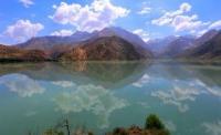
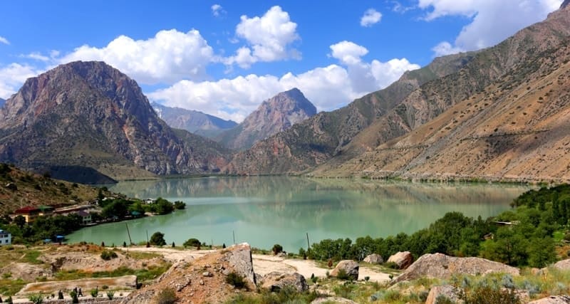
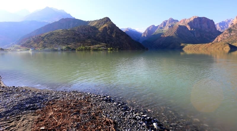
Iskanderkul lake.
Tours on lake Iskanderkul.
“I've known rivers:
I've known rivers ancient as the world and older than the flow of human blood in human veins. My soul has grown deep like the rivers”
Langston Hughes.
Lake Iskanderkul sights.
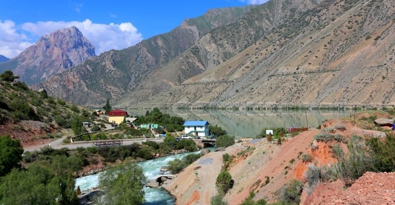
Fresh, flowing lake Iskanderkul (taj. Iskandarkul) is located at an altitude of 2,194.8 m. a. s. l., located in west of Khazormech mountains, in east of Bartursofi natural landmark, in spurs of Kuhistan mountain (Fany Mountains) knot, between western extremities of Gissar and Zerafsha ranges in Penjikent region Sughd region.
According to legend, Lake Iskanderkul got its name from Alexander the Great, who was called Iskander Zulkarnain (Iskander two-horned) in the East. The word "kul" (taj. Kul, uzb. Ko'l) means actually "lake", hence the name - "Iskanderkul".
Alexander the Great allegedly visited here on his way from Central Asia to India.
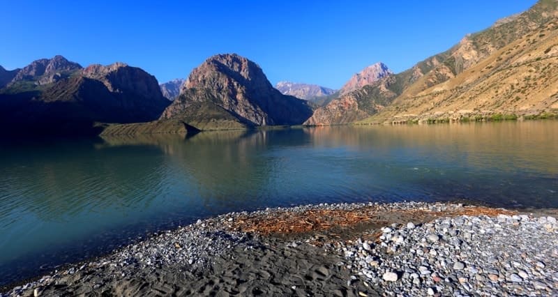
The lake has a dammed type of structure, dammed up with ancient moraine, covered with rock from above, which was the result of a collapse, possibly due to a strong earthquake. The perimeter of the lake is 11,766 meters, the total area of the lake's water surface is 3.47 square kilometers, the depth of the lake reaches 72 meters, the volume, according to 1978, was 0.24 cubic kilometers.
The length of the lake from the south-east to the north-west is 2861 m. a. s. l., the greatest width in the western part is 2799 m. a. s. l. In ancient times, the lake had a higher water level, traces of which can be seen on the slopes of the surrounding mountains, at an altitude of over 120 meters.
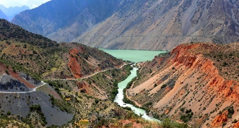
The Khazormech and Serideval rivers flow into the lake from the southeast, a large tributary Sarytag flows into the lake from the southeast, and a small tributary of the Serim, as well as small mountain streams, flow into the lake from the northwest.
In the northern part of the lake flows the river - Iskanderdarya, belonging to the basin of the Zeravshan river. According to the classification of natural waters according to the allocation of hydrochemical facies by G.A. Maksimovich, Iskanderkul is included in the zone of mountainous territories of a hydrocarbonate hydrochemical formation with a predominance of hydrocarbonate-calcium waters and in the scientist's table looks as follows.
In the northern part of Lake Iskanderkul, 370 meters away, there is a dammed lake - Zamin-Mulla (known among tourists as Serpentine or Serimadarun, which receives part of the runoff of the Serima River. In the north-east of the lake, 1306 meters, on the Iskanderdary river, there is a large waterfall called "Fany Niagara".
On the bank of Iskanderkul there is a historical monument - a large limestone rock with the inscription "Ruskie, 1870" carved on it, which was left by the members of the first expedition of Alexei Fedchenko, who penetrated here from the direction of Zeravshan.
On the shore of the lake there is also the Tajikhydromet meteorological station and a hydrological observation point, operating all year round. There is also a tourist base with the necessary infrastructure. There are many legends about the lake.
The highest of the surrounding peaks, the White Leopard Peak, 4506.6 m. a. s. l., raised its gray head of snow. The turquoise color of the lake water effectively contrasts with the red-brown rocks on the mountain slopes. (The Fany Mountains are composed mainly of limestone, which iron oxides have stained with all wreaths of rust.)
Iskanderkul resembles a triangle in shape. The turquoise azure waters of the precious crystal contrast spectacularly with the almost vegetationless, red-brown cliff slopes that descend to the water itself. Rapid mountain rivers - Sarytag, Serima and Khozormech, rushing through wooded gorges, bring their scalding cold waters into the lake.
A narrow strip of willow, wild rose, barberry, and sea buckthorn bushes borders the lake shores. The water in Iskanderkul is quite cold, but it is quite possible to swim near the coast and in closed bays in summer. For the winter, Iskanderkul almost completely freezes, only in the middle of the lake there is a narrow strip of clean water formed by a jet of an underwater current.
The coastal area is inhabited by snow leopards, bears, hoopoes, mountain partridges - partridges, turkeys - ulars. However, Iskaderkul cannot boast of an abundance of life, its waters are inhabited only by small fish - char. The shores of the lake are mostly steep, steep in places; four terraces (located at heights of 17, 35, 90 and 117 meters) testify to its higher level in the past.
Geographic coordinates of Lake Iskanderkul: N39°04'30 E68°21'50

Authority:
Books: "Fan Mountains", authors A.S. Mukhin, V.F. Gusev. "Nature of Tajikistan" publishing house "Mysl", 1982. Pavel Luknitsky. "Travels in the Pamirs", Young Guard, 1955. "Pamir", publishing house "Planeta" 1987, edited by Corresponding Member of the USSR Academy of Sciences M.S. Asimova. "Stone miracle of Tajikistan", V.P. Novikov, R.B.Baratov, publishing house "Irfon", 1988.
Websites:www.fany.ru: www.aru-kem.ru: www.skitalets.ru
Photos by
Alexander Petrov.