


![]()
You are here
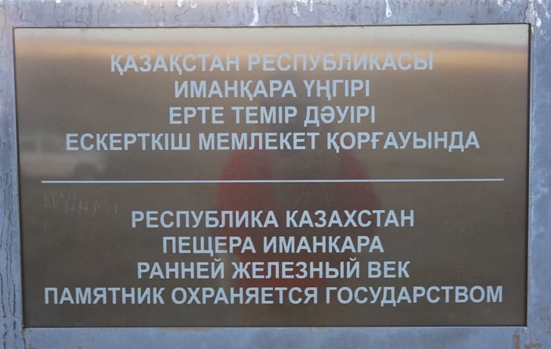
Imankara Cave in Atyrau region.

Expedition tours in Kazakhstan.
"We'll take the horizon's circle with us on our journey,
Here, a land rich in oil stretches out around us.
The centuries gnaw at your sides
Mercilessly,
And the distance, under the scorching sun, is deserted and wild."
Yuri Pastukhov. "Land of Snow-White Stories."
Traveling to tourist places of Atyrau region.
Geographical location of Imankara Cave.
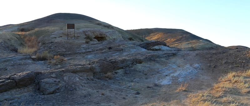
Imankara Cave, located at an altitude of 193 meters above sea level, is on western slope of Mount Imankara, 8.8 kilometers southeast of Kalyshkuduk valley, 11.4 kilometers northeast of Akergeshen chalk plateau, 34.5 kilometers northeast of village of Akkiztogay, and 59.8 kilometers northeast of town of Kulsary in Zhaloi district in eastern Atyrau region.
Imankara Cave is hidden in quiet steppes of Zhalyoi district in east of Atyrau region.
Imankara Cave is located on the western slope of the mountain of the same name, at an altitude of approximately 193 meters above sea level, in the eastern part of the Zhylyoi district of the Atyrau region. The surrounding area is an arid plain, interrupted by island hills and chalk plateaus, where steppe meets the remnants of an ancient sea, and time meets silence.
Geological Nature of Imankara Cave.
The mountain and the massif to which the cave belongs are composed primarily of marl and limestone, formed during the Late Cretaceous period. Millions of years ago, the warm, shallow Tethys Ocean, rich in organic matter and shell sediments, extended here.
Over time, the rocks were uplifted by tectonic processes, and wind and water erosion formed the characteristic steep ledges, outcrops, and crevices. Imankara Cave is located in a hilly steppe region near the border with the Aktobe region, approximately 6 kilometers from the highway to the village of Mukur.
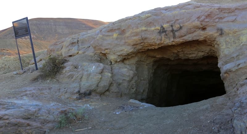
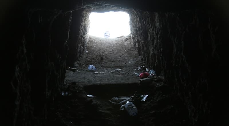
From the outside, it appears small; the modest entrance in the dark sedimentary rocks attracts little attention and does not suggest any significant interior space. However, appearances are deceptive: behind the narrow opening lies a branching system of corridors and niches, the total area of which reaches approximately 80 square meters.
Layout and structure of Imankara Cave.
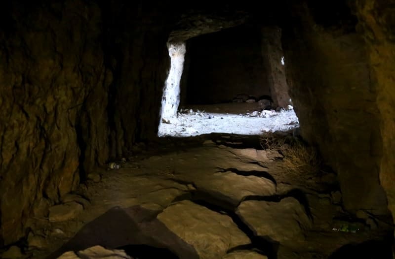
The main corridor of the cave extends approximately 10 meters into the massif, after which it divides into two branches: The right passage is approximately 7 - 8 meters long. The left passage is longer, 11 - 12 meters, and has an additional side branch in the form of a small "room" measuring approximately 2 x 1.5 meters.
The ceiling height reaches approximately 2.20 meters, allowing one to move around at full height inside, although one must crouch to enter the cave. Traces of chopping tools are clearly visible on the walls, indicating the man-made origin of the interior. The cave was not washed out by natural processes; it was deliberately carved out of bitumen-containing rock.
Historical context and purpose of Imankara Cave.
In the early XXth century, these areas attracted industrialists who conducted geological exploration for hydrocarbons. In 1911, Swedish entrepreneur Emanuel Nobel (a member of the Nobel family) acquired the concession to develop the Emba deposits.
The remains of a drilling rig from that period still remain in the vicinity of the cave.
Purpose of cave is not known for certain, but indirect evidence suggests that:
it could have been used as a refrigerated warehouse, where lubricants or food products were stored in constant cool conditions;
It could have served as a refuge and resting place for drilling workers, especially given the intense summer heat in these areas;
its interior layout, with small "cell-rooms," suggests a shelter and temporary residence rather than an attempt at deep mining.
A military page in history of Imankara Cave.
The cave is also associated with a little-known chapter of the Great Patriotic War. In the spring of 1944, a German sabotage force was dropped into these steppes. For a long time, the operation went unmentioned, and only in the 1970s and 1980s did it become known thanks to the memoirs of NKVD officers.
A group of five saboteurs, including the traitor Agayev, was discovered and blocked by security officers with the support of units from Guryev, Aktyubinsk, and Dossor. An offer to surrender was met with automatic fire. A machine gunner belonging to the saboteurs was killed in the firefight, and then a grenade suppressed the machine gun crew.
Surrounded by a tight ring, the saboteurs continued their resistance to the end and were destroyed.
Natural Setting of Imankara Cave.
Cave's surroundings are characterized by a landscape of high clay-sand and chalk hills covered with rare xerophytes:
- kermek and saltwort,
- wormwood,
- rare saxaul in the depressions,
- shrubs including calligonum and kurai.
Fauna includes foxes, jerboas, great gerbil (Rhombomys opimus), steppe cats, lizards (round-headed lizards, agamas), and migratory birds in the spring and fall.
Historical and Cultural Aspects of Imankara Cave.
Local residents have long considered the mountain a place of power. The word "Iman" in the name is no accident - it connects the place with the concept of faith and spiritual solitude. According to one local oral tradition, travelers and Sufi dervishes, seeking silence for prayer and contemplation, stopped in the cave at various times.
From the 19th century until the mid-XXth century, the cave was periodically mentioned in reports by geologists and topographers, but no serious archaeological research has been conducted here.
Legend of Imankara Cave.
They say that an old mullah named Kara-Ata once lived in these lands. He was searching for a place where a person could hear the quiet voice of the heart, and one day, tired from the journey, he took refuge in the shadow of a rock. The night brought a storm, the wind howled like a beast, and the sand cut his face.
But in the morning light, he saw the entrance to the cave - dark, but not frightening, as if calling him inside. He remained there for three days, in silence. They say he emerged from the cave a changed man - soft as water and strong as stone. Since then, people have called this place Imankara - the mountain where faith returns to the heart.
Imankara Cave Condition and Safety Precautions.
Imankara Cave is a monument without any established tourist infrastructure. Inside, there are sections with uneven floors, crumbling rock edges, and isolated fragments of cracks in the ceiling. Although the main corridor and branches remain fairly stable, caution is required when visiting.
Wearing a helmet or a thick hat is recommended:
You must have at least two sources of light (a flashlight and a spare one).
When entering, stay close to the walls, avoiding sudden movements on areas of soft rock.
After rains and in the spring, condensation and small particles may accumulate, so it is best to visit the cave during the dry season. Important: The cave is not fenced or illuminated. Movement is entirely dependent on the traveler's equipment and experience.
Tips for tourists and travelers visiting Imankara Cave.
Best time to visit:
late spring, early summer, and September. In summer, surface temperatures can reach 40°C, but the cave remains cool inside.
How to get there:
Access is via dirt roads, passable in dry weather for most high-clearance vehicles. After rain, travel is very difficult.
What to bring:
- Flashlight + spare batteries.
- Hat or helmet.
- Gloves.
- Sufficient water supply - there are no water sources nearby.
- GPS or precise route maps - landmarks in the steppe are blurred
Clothing:
Lightweight, but covering, providing protection from the sun and wind; shoes: with sturdy soles.
Behavior at the site:
- Do not leave inscriptions or marks on the walls;
- Do not dismantle the stone structures;
- Preserve the natural appearance of the site.
A visit to Imankara Cave is a journey into a landscape where steppe, stone, and history intertwine into a single space. Proper preparation makes this trip safe and fulfilling.
A final note about Imankara Cave.
Imankara is more than just a shelter carved into the bitumen rocks. It is a place where human labor, the history of steppe exploration, and the quiet traces of bygone eras converge in a single space. Here, in the cool corridors, drillers and geologists once rested, here steppe dwellers waited out the heat and winds, here legends were whispered about people who came to reap the riches of the land.
Time passed, the people departed, but the stone remained. Imankara is a place where time preserves the shadows of those who lived, worked, and dreamed on this land.
Geographic coordinates of Imankara cave are: N47°24'09 E54°28'12
Authority:
Alexander Petrov.
Miral Dzharmukhambetov (Aktobe Herald “Last Lair of Traitor”).
Photos by:
Alexander Petrov.