


![]()
You are here
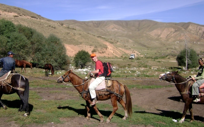
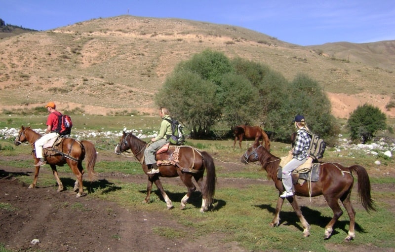
Horseback tour in Kungey Alatau mountains in Kazakhstan.


Travel on horses in Almaty province.
“Travel is fatal to prejudice, bigotry, and narrow-mindedness, and many of our people need it sorely on these accounts. Broad, wholesome, charitable views of men and things cannot be acquired by vegetating in one little corner of the earth all one's lifetime”
Mark Twain.
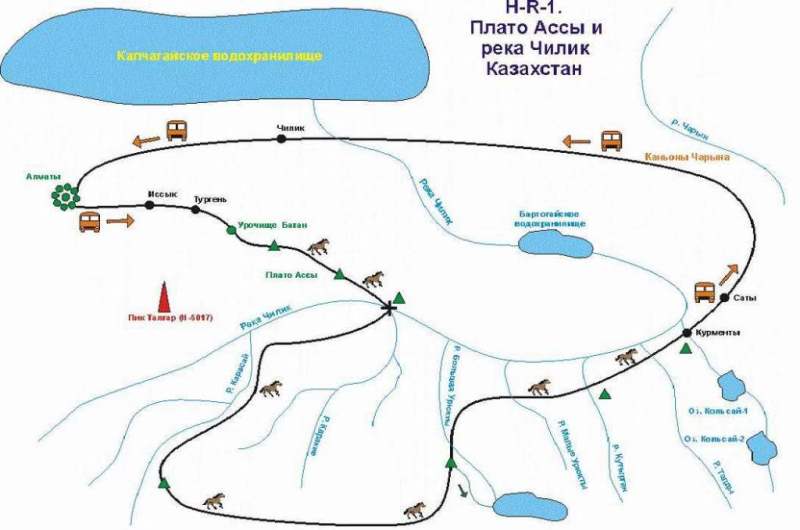
Geographic location of horseback riding tour route in Zailiysky Alatau.
The horseback riding program covers a small area in the Kungey Alatau range of the Northern Tien Shan Mountains.
Northern Tien-Shan Mountains.
The range stretches 400 km from west to east and is divided into two watershed ranges: the Zailiysky Alatau (the first range beyond the Ili River), approximately 280 km long and 40 to 60 km wide, with its northern slopes located in southeastern Kazakhstan, and the Kungey Alatau ("variegated snow-capped mountains facing the sun"), 275 km long and 31 km wide on average, located in Kyrgyzstan.
The highest point of the Kungey Alatau is Chaktal Peak, 4,771 m above sea level. and the Trans-Ili Alatau – Talgar Peak, 5,017 meters above sea level. This mountain range belongs to the Chilik-Kemin mountain range. The highest part of the range is located between the Kastek Pass (2,825 meters above sea level) in the west and the Amanzhol Pass (3,510 meters above sea level) in the east, and is approximately 180 kilometers long.Large glaciers include the Korzhenevsky, Bogatyr, Shokalsky, Tuyuk-Su, Dzhangaryk, Tsentralny, Aksuysky, Syutbulaksky, Chon-Aksuysky, and Choktalsky Glaciers.
Climate in Kungey Alatau Range.
The climate of the region is continental, due to the topography, altitudinal zonation, and the presence of the deep, ice-free Lake Issyk-Kul. During the summer months, at an altitude of 3,600 meters, the maximum temperature in July reaches +18 degrees Celsius.
The climate along the northern shore of the lake is moderate, with warm winters and cool summers. The average temperature on the coast in July is 16.5 degrees Celsius, and in August, 16.9 degrees Celsius.
Temperature in Kungey Alatau Mountains.
The coldest months are January and February, with average monthly temperatures ranging from -17 degrees Celsius to -24 degrees Celsius, and in the high-altitude basins, from -14 degrees Celsius to -17 degrees Celsius in the mountains of the southern part.
The warmest month is July, with average monthly temperatures ranging from +14 degrees Celsius to +22 degrees Celsius. In July, at altitudes of 1,000–1,500 meters above sea level, temperatures can reach -0 degrees Celsius. In the highlands, the air temperature decreases by 0.6 degrees Celsius for every 100 meters of increase in altitude.
Sunny days in Kungey Alatau Mountains.
The most favorable days are the summer months. In July, there are, on average, no more than 17 sunny days, and in September, no more than 14. At the bottoms of deep valleys within the treeline, the maximum number of favorable days is in August and September – 17 days. Nights in the forest zone during the summer months are frost-free.
Winds in Kungey Alatau Mountains.
During the summer months, moist westerly and northeasterly mountain-valley winds blow. Wind speeds are moderate, but they increase in the morning.
Precipitation in Kungey Alatau Mountains.
In summer, precipitation is high, reaching 2,200 mm. At an altitude of 2,600 meters above sea level, snow falls in the third ten days of August. During the rainy season, cloud cover is very low, obscuring passes and peaks. Precipitation in July and August reaches up to 900 mm.
Precipitation increases with altitude, ranging from 433 to 633 mm per year in the mountains. Maximum precipitation occurs in July. The southern slopes of the mountains receive 1.5 to 2 times less precipitation than the northern slopes. From west to east, precipitation increases from 119 to 538 mm.
Itinerary and difficulties of "Horseback Riding Tour in Kungei Alatau Mountains (Kazakhstan)" tour.
The tour program does not include any difficulties; horseback riding is within the capabilities of any healthy person. Accommodations throughout the tour are in single and double tents.
Brief description of a route of tour on horses in Almaty province:
Almaty - settlement Issyk - gorge Turgen - plateau Assy - pass Assy - Assy-Turgen an observatory - Pass Amanzhol - pass Akkiya - river Chilik - mouth of river Karakie - mouth of river Karakie - river Chilik - riverheads Karasai - river Karasai - plateau Mynzhilki - river Karakshi - plateau Urykty- river Greater Urykty - river Karasai - river Greater Urykty - river Small Urykty - valley Sarykerege - mouth of river Kutyrgan - river Greater Urykty - river Small Urykty - valley Sarykerege - mouth of river Kutyrgan - river Kutyrgan - pass of Bota Moinok - river Taldy - settlement Kurmenty - settlement Saty - settlement Zhalanash - settlement Chilik - town Almaty.
Distance of route: 502 km.
Season: from 10 of July, till September, 15th.
Best time for horse riding: July - August.
Quantity of tourists: no more than 6 person.
Advanced order: for 15 days.
Duration of tour: 11 days, 10 nights.
The detailed description of a route of tour horse riding on Northern Tien-Shan:
Voyage of discovery in Kazakhstan.
Day 1. Almaty.
Arrival in Almaty.
A meeting at the airport, transfer to hotel, accommodation. Rest. Breakfast. Excursion on town: visiting of park 28 Panfilovzev, a museum of musical instruments, a national museum, natural boundary Medeo, the area of Republic. Returning in hotel, overnight.
Day 2. Almaty - settlement Issyk - settlement Turgen - gorge Turgen - forest Batan - plateau Assy - pass Assy - observatory Assy - natural landmark Amanzhol (106 km).
Breakfast. Transfer: Almaty - natural landmark Amanzhol.
After we driving Almaty, our way will lay on ancient Kuldzha to a path. After settlement Avat the road turns on the south in a direction of mountains Zailiiskiy Ala-Tau and settlement Issyk. On a way visiting Issyk Saka barrows in which vicinities in 1962, archeologists, the Gold person of Kazakhstan has been found.
Transfer: museum «Issyk» - settlement Issyk - gorge Turgen - natural landmark Batan - departure plateau Asy (45 km).
After visiting a museum our way lays through regional center Issyk through which the river Issyk proceeds. Soon the road goes to gorge Turgen, a stop on ecological to a post of national park "Ile-Ala-Tau". Before us picturesque kinds on gorge Turgen open.
The road is laid along the river of the fast and transparent river Turgen, winds and soon the road leaves gorge and passes in the beginning of plateau Asy. A stop on a height at the river Turgen. Walk on breakage with which opens a kind on neighboring mountains and the river Turgen.
The further transfer: plateau Asy - pass Assy of 2510 m. a. s. l. (8 km). A stop on pass Assy. From pass opens fine kinds on neighboring mountains and a valley of the river Assy, dzhailyau which were stretched from the West on the east. In the south and the West tower snow mountains Zailiiskiy of Ala-Tau.
Transfer: pass Assy – Asy-Turgen an observatory (3 km). From pass on road we move on a southwest and soon before us a wide plateau in the center which there is observatory Asy-Turgen. On the north and northwest magnificent wide panoramas of plateau Asy open, snow southern crest Zailiiskiy Ala-Tau in the south towers.
Arrival in valley Amanzhol, here we meet the groom and horses on whom we shall travel. Acquaintance to the groom, walks on horses. Accommodation in tents, overnight.
Day 33. Natural landmark Amanzhol - pass Amanzhol (10 km).
Breakfast. The beginning of travel on horses in mountains Northern Tien-Shan.
After a breakfast our way lays from natural landmark Amanzhol on an old highway, in parallel the river Kyzyl-Bulak. Our day time horse riding will end under pass Amanzhol, on lawns of a green grass. Overnight.
Day 4. Pass Amanzhol of 3515 m. a. s. l. - pass Akkiya of 2948 m. a. s. l. - river Chilik - mouth of river Karakie of 2043 m. a. s. l. (14 km).
Breakfast. Rise on pass on a track which goes aside the rivers Chilik, on a track is not present difficulties. From pass Amanzhol the panorama on the river Chilik which is twisted far in gorge, on huge plateau Assy which Alatau is in northern direction and northern slopes of ridge Kungey opens. From pass the flat track goes along the river Amanzhol to a mouth of the river Karakie. Overnight.
Day 5. A mouth of river Karakie - river Chilik - riverheads Karasai of 2202 m. a. s. l. (13 km).
Breakfast. Horse riding to riverheads Karasai.
From a mouth of the river Karakie it is risen on the left coast of the river Chilik, we cross the river on the old bridge and we pass to the right coast of the river, near to a place of a ferry there is ancient a cemetery of shepherds-kazakhs. Then we meet a fir forest, we leave to the river Karasai and on the right coast through the Alpine meadows we leave to riverheads Karasai. Overnight.
Day 6. River Karasai - plateau Mynzhilki of 2780 m. a. s. l. - river Karakshi of 2300 m. a. s. l. - plateau Urykty of 2720 m. a. s. l. - river Greater Urykty 2279 m. a. s. l. (16 km).
Breakfast. Horse riding to river Big Urykty.
After a breakfast we continue a way from riverheads Karasai to plateau Mynzhilki along the right coast of the river Karasai. Plateau Mynzhilki is big dzhailyau where herds of sheeps are grazed, cows, herds of horses and yaks. Here we shall see yurts and tents of shepherds to which like these places here a lot of a green grass and fresh a climate.
After horesr riding through a plateau, we go down in a valley of the river Karakshi. After a lunch we rise on the following of plateau Urykty, the fine panorama Northern Tien-Shan with the highest peak Talgar of 5017 meters above sea level from here opens.
From plateau Urykty our way passes in beautiful valley the rivers Chon-Uryukty with the Alpine meadows of a high grass. Overnight.
Day 7. Radial walk on horses to lake Chon-Uryukty of 3640 m. a. s. l. (18 km).
Breakfast. Today at us walk on horses to lake Chon-Uryukty,
thenatural landmark passes from one coast of the river to another, we gradually gain height. Our way passes along the river and soon the wood remains below, the vegetation varies, far below there are meadows with plentiful motley grass, the track leaves to a moraine of lake.
Soon we at lake Chon-Uryukty which, is in a stone hollow, in lake small streams run many. Returning in camp on the river Greater Urykty. Overnight.
Day 8. River Greater Urykty - river Small Urykty 2007 m. a. s. l. - natural landmark Sarykerege of 1788 m. a. s. l. - mouth of river Kutyrgan of 1761 m. a. s. l. (15 km).
Breakfast. After a breakfast we are sent in a way along the right coast of the picturesque river Chilik, in a way we wade on horses the river Small Urykty and we pitch up the tents in a mouth of the river Kutyrgan. The hiking in vicinities. Overnight.
Day 9. A mouth of river Kutyrgan - pass of Bota Moinok - river Taldy of 1635 m. a. s. l. - settlement Kurmenty (20 km).
Breakfast. The end of travel on horses. Horse riding in settlement Kurmenty.
Today our way lays through a wood on the right coast of the river Chilik. Soon we in small Kazakh settlement Kurmenty. Overnight in the guest house "Kurmeny".
Day 10. Settlement Kurmenty - settlement Saty of 1429 m. a. s. l. - settlement Zhalanash - settlement Chilik - town Almaty (300 km).
Breakfast. Transfer to Almaty.
Arrival in Almaty, accommodation in hotel. A free time, overnight in hotel.
Day 11. Almaty - airport.
Accompanying service at departure to airport, departure from Almaty.
The note:
1. During travel on horses, tourists can give of 15 kg which are transported on horses of service for transportation of the personal things.
2. Accommodations throughout the tour are in single and double tents.

The note:
Author program is Alexander Petrov. Copying and use - from the sanction of the author.
Alexander Petrov
photos by: